Property Record
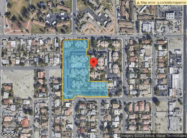
84851 Bagdad Ave, Coachella, CA 92236
NEARBY LISTINGS FOR SALE OR LEASE
Property Detail
84851 Bagdad Ave
Riverside-San Bernardino-Ontario, CA
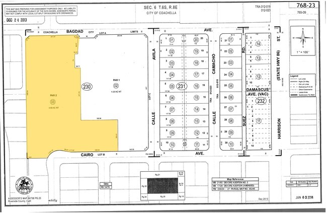
Parcel Map No 36246
768-230-003
4.69 ACRES NET IN PAR 2 PM 235/024 PM 36246
Apartment
Riverside
X
California
06065C2270H
2
2024
4.69 AC
2025
Coachella Valley
045704
Inland Empire (California)
48,140 SF
DEMOGRAPHICS near 84851 Bagdad Ave
1 Mile
3 Mile
5 Mile
2024 Total Population
23,756
59,330
124,651
2029 Population
25,093
62,924
133,199
Pop Growth 2024-2029
+ 5.63%
+ 6.06%
+ 6.86%
Average Age
32
35
37
2024 Total Households
5,596
15,519
36,850
HH Growth 2024-2029
+ 5.31%
+ 6.42%
+ 7.45%
Median Household Inc
$36,650
$47,570
$56,455
Avg Household Size
4.20
3.70
3.30
2024 Avg HH Vehicles
2.00
2.00
2.00
Median Home Value
$262,264
$315,205
$364,686
Median Year Built
1989
1997
1995
Nearby Places
Map Layers
Map Styles
 Street
 Aerial
- Restaurants
- Banks
- Shops
- Fitness
- Groceries
PUBLIC TRANSPORTATION
AIRPORT
Palm Springs International
DRIVE
WALK
Distance
Palm Springs International
37 min
27.1 mi
Nearby Properties
Address
Land Use
TOTAL SIZE
Lot Size
Zoning
Address
Land Use
TOTAL SIZE
Lot Size
Zoning
52,901 SF
6 AC
Address
Land Use
TOTAL SIZE
Lot Size
Zoning
133,694 SF
5.83 AC
Address
Land Use
TOTAL SIZE
Lot Size
Zoning
177,392 SF
25.40 AC
MH
Address
Land Use
TOTAL SIZE
Lot Size
Zoning
41,091 SF
4.65 AC
Address
Land Use
TOTAL SIZE
Lot Size
Zoning
105,122 SF
2.23 AC
Address
Land Use
TOTAL SIZE
Lot Size
Zoning
275,931 SF
37.69 AC
Address
Land Use
TOTAL SIZE
Lot Size
Zoning
100,110 SF
4.03 AC
Address
Land Use
TOTAL SIZE
Lot Size
Zoning
86,479 SF
6.46 AC
Address
Land Use
TOTAL SIZE
Lot Size
Zoning
44,511 SF
9.40 AC
CM
Address
Land Use
TOTAL SIZE
Lot Size
Zoning
34,312 SF
3.15 AC
Address
Land Use
TOTAL SIZE
Lot Size
Zoning
40,380 SF
17.55 AC
Address
Land Use
TOTAL SIZE
Lot Size
Zoning
30,000 SF
2.98 AC
Address
Land Use
TOTAL SIZE
Lot Size
Zoning
53,705 SF
5.10 AC
A1
Address
Land Use
TOTAL SIZE
Lot Size
Zoning
31,708 SF
5.07 AC
R3
Address
Land Use
TOTAL SIZE
Lot Size
Zoning
37,282 SF
9.92 AC
CG
Address
Land Use
TOTAL SIZE
Lot Size
Zoning
58,586 SF
6.03 AC
Address
Land Use
TOTAL SIZE
Lot Size
Zoning
13,888 SF
4.36 AC
R3
Address
Land Use
TOTAL SIZE
Lot Size
Zoning
74,437 SF
8.80 AC
R1
Address
Land Use
TOTAL SIZE
Lot Size
Zoning
42,247 SF
8.40 AC
Address
Land Use
TOTAL SIZE
Lot Size
Zoning
76.89 AC
A120
Address
Land Use
TOTAL SIZE
Lot Size
Zoning
140,069 SF
8.37 AC
M
Address
Land Use
TOTAL SIZE
Lot Size
Zoning
1,589 SF
65.71 AC
A110
Address
Land Use
TOTAL SIZE
Lot Size
Zoning
19,059 SF
8.15 AC
Address
Land Use
TOTAL SIZE
Lot Size
Zoning
34,458 SF
4.27 AC
R3
Address
Land Use
TOTAL SIZE
Lot Size
Zoning
21,170 SF
7.27 AC
RM
Address
Land Use
TOTAL SIZE
Lot Size
Zoning
76,880 SF
8.30 AC
Address
Land Use
TOTAL SIZE
Lot Size
Zoning
25,370 SF
6.61 AC
A1050
Address
Land Use
TOTAL SIZE
Lot Size
Zoning
Address
Land Use
TOTAL SIZE
Lot Size
Zoning
42,249 SF
4.97 AC
Address
Land Use
TOTAL SIZE
Lot Size
Zoning
14,820 SF
1.55 AC
CG
The World's #1 Commercial Real Estate Marketplace
Connect with us
© 2025 CoStar Group
The information above has been obtained from sources believed reliable. While we do not doubt its accuracy we have not verified it and make no guarantee, warranty or representation about it. It is your responsibility to independently confirm its accuracy and completeness. Any projections, opinions, assumptions, or estimates used are for example only and do not represent the current or future performance of the property. The value of this transaction to you depends on tax and other factors which should be evaluated by your tax, financial, and legal advisors. You and your advisors should conduct a careful, independent investigation of the property to determine to your satisfaction the suitability of the property for your needs.