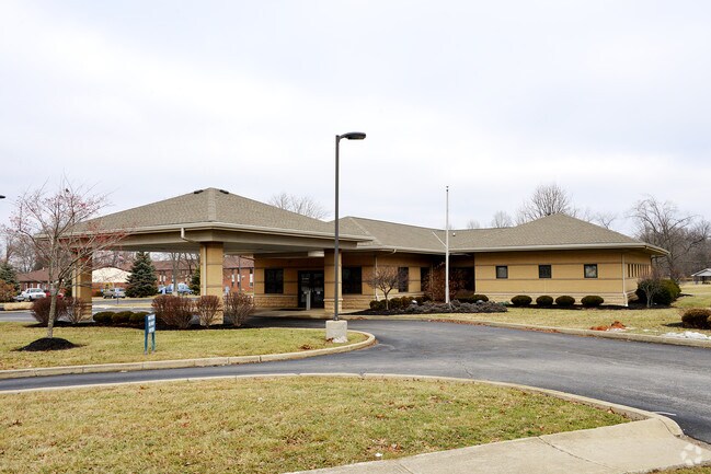
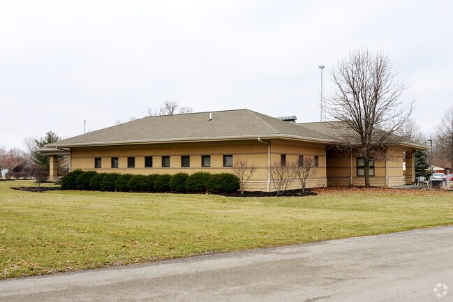
Property Record
849 Cherry St, Blanchester, OH 45107

NEARBY LISTINGS FOR SALE OR LEASE
Property Detail
849 Cherry St
220-08-15-11-0000-00
Vms 1121
Medicalbuilding
EXT MS 1121 COMB FR 220-006442-2 & RES TO BE 2.012 AC FOR 2011 DUP
X
Clinton
39027C0236E
Ohio
2024
2.01 AC
2024
Ohio South Area
964900
Other Market Areas
4,542 SF
Wilmington, OH
DEMOGRAPHICS near 849 Cherry St
1 Mile
3 Mile
5 Mile
2024 Total Population
3,854
6,174
10,258
2029 Population
3,916
6,270
10,416
Pop Growth 2024-2029
+ 1.61%
+ 1.55%
+ 1.54%
Average Age
41
41
41
2024 Total Households
1,526
2,419
3,893
HH Growth 2024-2029
+ 1.57%
+ 1.49%
+ 1.44%
Median Household Inc
$43,308
$55,523
$66,081
Avg Household Size
2.40
2.50
2.60
2024 Avg HH Vehicles
2.00
2.00
2.00
Median Home Value
$116,010
$140,763
$174,544
Median Year Built
1971
1973
1976
Nearby Places
Map Layers
Map Styles
 Street
 Aerial
- Restaurants
- Banks
- Shops
- Fitness
- Groceries
Nearby Properties
Address
Land Use
TOTAL SIZE
Lot Size
Zoning
Address
Land Use
TOTAL SIZE
Lot Size
Zoning
114,436 SF
46.31 AC
PUB
Address
Land Use
TOTAL SIZE
Lot Size
Zoning
71,601 SF
2.19 AC
PUB
Address
Land Use
TOTAL SIZE
Lot Size
Zoning
66,729 SF
5.67 AC
PUB
Address
Land Use
TOTAL SIZE
Lot Size
Zoning
269,586 SF
41.92 AC
I1
Address
Land Use
TOTAL SIZE
Lot Size
Zoning
413.04 AC
A3
Address
Land Use
TOTAL SIZE
Lot Size
Zoning
72,415 SF
11.18 AC
B5
Address
Land Use
TOTAL SIZE
Lot Size
Zoning
6,864 SF
4.27 AC
PUB
Address
Land Use
TOTAL SIZE
Lot Size
Zoning
2,200 SF
5.09 AC
PD
Address
Land Use
TOTAL SIZE
Lot Size
Zoning
30,789 SF
5 AC
Address
Land Use
TOTAL SIZE
Lot Size
Zoning
1,340 SF
4.30 AC
B2
Address
Land Use
TOTAL SIZE
Lot Size
Zoning
202.08 AC
RR
Address
Land Use
TOTAL SIZE
Lot Size
Zoning
42,706 SF
5.41 AC
R6
Address
Land Use
TOTAL SIZE
Lot Size
Zoning
829 SF
180.70 AC
A3
Address
Land Use
TOTAL SIZE
Lot Size
Zoning
24,726 SF
3.53 AC
R6
Address
Land Use
TOTAL SIZE
Lot Size
Zoning
173.25 AC
A3
Address
Land Use
TOTAL SIZE
Lot Size
Zoning
98,620 SF
13.86 AC
I1
Address
Land Use
TOTAL SIZE
Lot Size
Zoning
164.77 AC
A3
Address
Land Use
TOTAL SIZE
Lot Size
Zoning
2,688 SF
39.70 AC
I2
Address
Land Use
TOTAL SIZE
Lot Size
Zoning
2,639 SF
130 AC
A3
Address
Land Use
TOTAL SIZE
Lot Size
Zoning
1,333 SF
117.36 AC
A3
Address
Land Use
TOTAL SIZE
Lot Size
Zoning
133.87 AC
A3
Address
Land Use
TOTAL SIZE
Lot Size
Zoning
133.67 AC
A3
Address
Land Use
TOTAL SIZE
Lot Size
Zoning
17,278 SF
1.74 AC
R6
Address
Land Use
TOTAL SIZE
Lot Size
Zoning
122.63 AC
A3
Address
Land Use
TOTAL SIZE
Lot Size
Zoning
12,112 SF
3.84 AC
Address
Land Use
TOTAL SIZE
Lot Size
Zoning
125.97 AC
RR
Address
Land Use
TOTAL SIZE
Lot Size
Zoning
119.86 AC
A3
Address
Land Use
TOTAL SIZE
Lot Size
Zoning
5,961 SF
1.56 AC
Address
Land Use
TOTAL SIZE
Lot Size
Zoning
118.46 AC
RR
Address
Land Use
TOTAL SIZE
Lot Size
Zoning
115.38 AC
RR
The World's #1 Commercial Real Estate Marketplace
Connect with us
© 2026 CoStar Group
The information above has been obtained from sources believed reliable. While we do not doubt its accuracy we have not verified it and make no guarantee, warranty or representation about it. It is your responsibility to independently confirm its accuracy and completeness. Any projections, opinions, assumptions, or estimates used are for example only and do not represent the current or future performance of the property. The value of this transaction to you depends on tax and other factors which should be evaluated by your tax, financial, and legal advisors. You and your advisors should conduct a careful, independent investigation of the property to determine to your satisfaction the suitability of the property for your needs.