Property Record
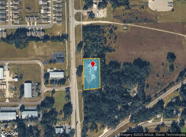
849 Nw State Road 45, Newberry, FL 32669
NEARBY LISTINGS FOR SALE OR LEASE
-
-
View all Newberry listings for sale on LoopNet.com
Property Detail
849 Nw State Road 45
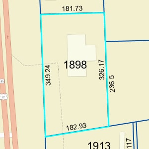
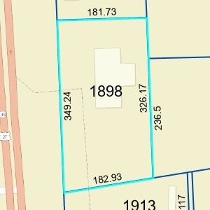
01898-000-000
COM NW COR OF SW1/4 OF SW1/4 S 2 DEG E 630 FT E 78.27 FT POB E 181.73 FT S 2 DEG E 326.17 FT S 81 DEG W 182.93 FT N 2 DEG W 349.24 FT POB OR 5165/3686
Departmentstore
Alachua
X
Florida
12001C0265D
1.28 AC
2025
Gainesville
2025
Other Market Areas
002201
Gainesville, FL
5,280 SF
DEMOGRAPHICS near 849 Nw State Road 45
1 Mile
3 Mile
5 Mile
2024 Total Population
2,593
6,978
10,515
2029 Population
2,785
7,476
11,334
Pop Growth 2024-2029
+ 7.40%
+ 7.14%
+ 7.79%
Average Age
38
39
39
2024 Total Households
947
2,591
3,915
HH Growth 2024-2029
+ 7.50%
+ 7.22%
+ 7.94%
Median Household Inc
$77,437
$81,144
$79,184
Avg Household Size
2.70
2.70
2.70
2024 Avg HH Vehicles
2.00
2.00
2.00
Median Home Value
$236,813
$240,451
$239,863
Median Year Built
1993
1992
1993
Nearby Places
Map Layers
Map Styles
 Street
 Aerial
- Restaurants
- Banks
- Shops
- Fitness
- Groceries
PUBLIC TRANSPORTATION
AIRPORT
Gainesville Regional
DRIVE
WALK
Distance
Gainesville Regional
42 min
23.1 mi
Freight Ports
Jacksonville Port
DRIVE
WALK
Distance
Jacksonville Port
128 min
92.9 mi
SALE & LEASE HISTORY
LISTING DATE
SALE/LEASE

Apr 03, 2024
For Sale
Nearby Properties
Address
Land Use
TOTAL SIZE
Lot Size
Zoning
Address
Land Use
TOTAL SIZE
Lot Size
Zoning
347,860 SF
9.62 AC
RSF-1
Address
Land Use
TOTAL SIZE
Lot Size
Zoning
568,885 SF
56.52 AC
RSF-2
Address
Land Use
TOTAL SIZE
Lot Size
Zoning
62,747 SF
9.96 AC
RSF-2
Address
Land Use
TOTAL SIZE
Lot Size
Zoning
117,042 SF
12.04 AC
CN
Address
Land Use
TOTAL SIZE
Lot Size
Zoning
10,950 SF
1.58 AC
C4
Address
Land Use
TOTAL SIZE
Lot Size
Zoning
42,650 SF
9.20 AC
CI
Address
Land Use
TOTAL SIZE
Lot Size
Zoning
28,103 SF
0.75 AC
PD
Address
Land Use
TOTAL SIZE
Lot Size
Zoning
21,123 SF
5 AC
A
Address
Land Use
TOTAL SIZE
Lot Size
Zoning
24,500 SF
14.88 AC
I
Address
Land Use
TOTAL SIZE
Lot Size
Zoning
29,136 SF
15 AC
A
Address
Land Use
TOTAL SIZE
Lot Size
Zoning
305.95 AC
PD
Address
Land Use
TOTAL SIZE
Lot Size
Zoning
42,280 SF
6.94 AC
CA
Address
Land Use
TOTAL SIZE
Lot Size
Zoning
30,209 SF
9.86 AC
RMF-1
Address
Land Use
TOTAL SIZE
Lot Size
Zoning
52,224 SF
9.06 AC
CA
Address
Land Use
TOTAL SIZE
Lot Size
Zoning
20,925 SF
3.91 AC
MU
Address
Land Use
TOTAL SIZE
Lot Size
Zoning
19,925 SF
2.68 AC
CI
Address
Land Use
TOTAL SIZE
Lot Size
Zoning
11,570 SF
40 AC
A
Address
Land Use
TOTAL SIZE
Lot Size
Zoning
69,281 SF
36.73 AC
PD
Address
Land Use
TOTAL SIZE
Lot Size
Zoning
13,125 SF
3.04 AC
ILW
Address
Land Use
TOTAL SIZE
Lot Size
Zoning
4,200 SF
10.17 AC
I
Address
Land Use
TOTAL SIZE
Lot Size
Zoning
4,530 SF
8.12 AC
CI
Address
Land Use
TOTAL SIZE
Lot Size
Zoning
13,580 SF
0.24 AC
PD
Address
Land Use
TOTAL SIZE
Lot Size
Zoning
7,387 SF
1.65 AC
PF
Address
Land Use
TOTAL SIZE
Lot Size
Zoning
7,832 SF
0.14 AC
PD
Address
Land Use
TOTAL SIZE
Lot Size
Zoning
54.97 AC
PF
Address
Land Use
TOTAL SIZE
Lot Size
Zoning
7,080 SF
0.17 AC
PD
Address
Land Use
TOTAL SIZE
Lot Size
Zoning
13,772 SF
0.22 AC
PD
Address
Land Use
TOTAL SIZE
Lot Size
Zoning
8,190 SF
1 AC
ILW
The World's #1 Commercial Real Estate Marketplace
Connect with us
© 2025 CoStar Group
The information above has been obtained from sources believed reliable. While we do not doubt its accuracy we have not verified it and make no guarantee, warranty or representation about it. It is your responsibility to independently confirm its accuracy and completeness. Any projections, opinions, assumptions, or estimates used are for example only and do not represent the current or future performance of the property. The value of this transaction to you depends on tax and other factors which should be evaluated by your tax, financial, and legal advisors. You and your advisors should conduct a careful, independent investigation of the property to determine to your satisfaction the suitability of the property for your needs.