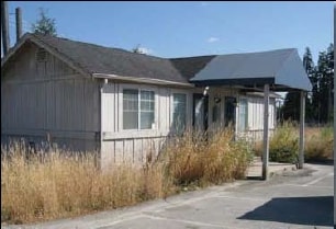
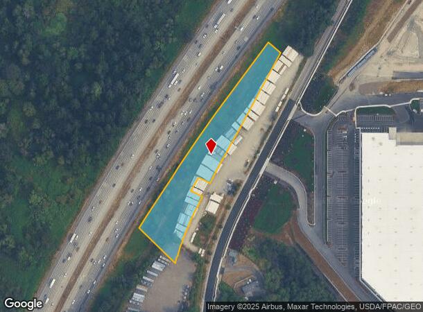
Property Record
85 5Th Ave S, Milton, WA 98354

NEARBY LISTINGS FOR SALE OR LEASE
-
-
No Photo
-
-
View all Milton listings for sale on LoopNet.com
Property Detail
85 5Th Ave S
Seattle-Tacoma-Bellevue, WA
Sp Kc-01-01
322104-9140
LOT 2 OF MILTON SHORT PLAT # KC01-01 REC #20011031900008 SD SP DAF - POR OF GL 2 IN SW 1/4 OF SEC 32-21-4 LY NELY OF PUYALLUP INDIAN RESERVATION & LY SELY & SLY OF SR 5 & LY NWLY OF MILTON RD S
Industrialacreage
King
ARE
Washington
53033C1250G
2
2025
2.35 AC
2024
Federal Way/Auburn
070703
Seattle/Puget Sound
DEMOGRAPHICS near 85 5Th Ave S
1 Mile
3 Mile
5 Mile
2024 Total Population
5,598
63,186
183,263
2029 Population
5,729
64,354
185,997
Pop Growth 2024-2029
+ 2.34%
+ 1.85%
+ 1.49%
Average Age
41
38
39
2024 Total Households
2,053
22,628
65,869
HH Growth 2024-2029
+ 2.29%
+ 1.84%
+ 1.46%
Median Household Inc
$102,791
$95,889
$86,698
Avg Household Size
2.70
2.70
2.70
2024 Avg HH Vehicles
3.00
2.00
2.00
Median Home Value
$503,720
$493,349
$455,347
Median Year Built
1987
1989
1985
Nearby Places
Map Layers
Map Styles
 Street
 Aerial
- Restaurants
- Banks
- Shops
- Fitness
- Groceries
PUBLIC TRANSPORTATION
AIRPORT
Seattle-Tacoma International
DRIVE
WALK
Distance
Seattle-Tacoma International
25 min
15.0 mi
Freight Ports
Port of Tacoma
DRIVE
WALK
Distance
Port of Tacoma
17 min
11.8 mi
Nearby Properties
Address
Land Use
TOTAL SIZE
Lot Size
Zoning
Address
Land Use
TOTAL SIZE
Lot Size
Zoning
41.11 AC
PD
Address
Land Use
TOTAL SIZE
Lot Size
Zoning
1 SF
150.54 AC
S10
Address
Land Use
TOTAL SIZE
Lot Size
Zoning
347,266 SF
39.15 AC
RM2400
Address
Land Use
TOTAL SIZE
Lot Size
Zoning
1,038,000 SF
51.55 AC
OP
Address
Land Use
TOTAL SIZE
Lot Size
Zoning
10,800 SF
85.18 AC
PMI
Address
Land Use
TOTAL SIZE
Lot Size
Zoning
582,536 SF
32.67 AC
I
Address
Land Use
TOTAL SIZE
Lot Size
Zoning
321,680 SF
31.59 AC
RM
Address
Land Use
TOTAL SIZE
Lot Size
Zoning
220,608 SF
5.41 AC
OP
Address
Land Use
TOTAL SIZE
Lot Size
Zoning
784,136 SF
10.80 AC
Address
Land Use
TOTAL SIZE
Lot Size
Zoning
258,297 SF
16.13 AC
BP
Address
Land Use
TOTAL SIZE
Lot Size
Zoning
588,800 SF
37.43 AC
I
Address
Land Use
TOTAL SIZE
Lot Size
Zoning
501,250 SF
29 AC
I
Address
Land Use
TOTAL SIZE
Lot Size
Zoning
542,750 SF
26.77 AC
TAC
Address
Land Use
TOTAL SIZE
Lot Size
Zoning
225,253 SF
27.58 AC
POS
Address
Land Use
TOTAL SIZE
Lot Size
Zoning
311,800 SF
39.84 AC
FIFE
Address
Land Use
TOTAL SIZE
Lot Size
Zoning
255,871 SF
11.17 AC
EDGWD
Address
Land Use
TOTAL SIZE
Lot Size
Zoning
208,900 SF
8.72 AC
EDGWD
Address
Land Use
TOTAL SIZE
Lot Size
Zoning
267,250 SF
16.82 AC
RM2400
Address
Land Use
TOTAL SIZE
Lot Size
Zoning
59,760 SF
78.60 AC
S10
Address
Land Use
TOTAL SIZE
Lot Size
Zoning
452,600 SF
18.54 AC
I
Address
Land Use
TOTAL SIZE
Lot Size
Zoning
417,125 SF
23.50 AC
I
Address
Land Use
TOTAL SIZE
Lot Size
Zoning
209,824 SF
9.16 AC
RC
Address
Land Use
TOTAL SIZE
Lot Size
Zoning
242,462 SF
16.05 AC
RM2400
Address
Land Use
TOTAL SIZE
Lot Size
Zoning
416,492 SF
26.05 AC
TAC
Address
Land Use
TOTAL SIZE
Lot Size
Zoning
204,620 SF
17.89 AC
RM2400
Address
Land Use
TOTAL SIZE
Lot Size
Zoning
1,424 SF
94.62 AC
S13
Address
Land Use
TOTAL SIZE
Lot Size
Zoning
212,544 SF
9.48 AC
R24
Address
Land Use
TOTAL SIZE
Lot Size
Zoning
339,623 SF
20.52 AC
I
Address
Land Use
TOTAL SIZE
Lot Size
Zoning
204,800 SF
47.01 AC
PMI
Address
Land Use
TOTAL SIZE
Lot Size
Zoning
960 SF
64.80 AC
PMI
The World's #1 Commercial Real Estate Marketplace
Connect with us
© 2025 CoStar Group
The information above has been obtained from sources believed reliable. While we do not doubt its accuracy we have not verified it and make no guarantee, warranty or representation about it. It is your responsibility to independently confirm its accuracy and completeness. Any projections, opinions, assumptions, or estimates used are for example only and do not represent the current or future performance of the property. The value of this transaction to you depends on tax and other factors which should be evaluated by your tax, financial, and legal advisors. You and your advisors should conduct a careful, independent investigation of the property to determine to your satisfaction the suitability of the property for your needs.