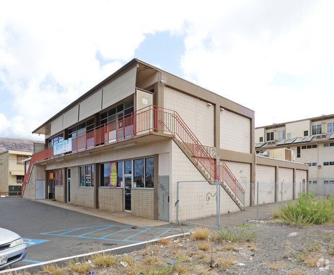
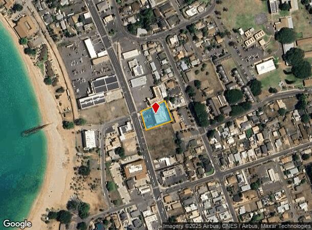
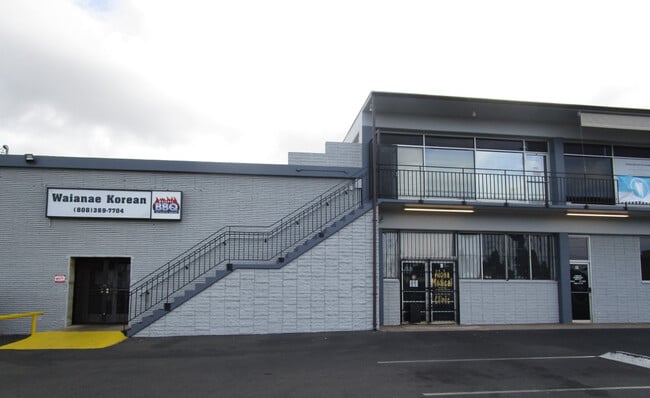
Property Record
85 Farrington Hwy, Waianae, HI 96792
Current Lease Availabilities
NEARBY LISTINGS FOR SALE OR LEASE
Property Detail
85 Farrington Hwy
1-8-5-010-058-0000
LOT 838 LCAPP NO. 1102 WAIANAE 27,904 SF
Commercialnec
Honolulu
X
Hawaii
15003C0183H
838
2024
0.64 AC
2025
Waianae
009705
Hawaii
11,200 SF
Urban Honolulu, HI
DEMOGRAPHICS near 85 Farrington Hwy
1 Mile
3 Mile
5 Mile
2024 Total Population
8,344
30,977
41,705
2029 Population
7,838
29,312
39,576
Pop Growth 2024-2029
(6.06%)
(5.37%)
(5.10%)
Average Age
37
37
37
2024 Total Households
2,037
7,966
10,332
HH Growth 2024-2029
(7.17%)
(5.64%)
(5.57%)
Median Household Inc
$63,421
$72,931
$74,066
Avg Household Size
3.60
3.40
3.50
2024 Avg HH Vehicles
2.00
2.00
2.00
Median Home Value
$471,874
$481,423
$498,390
Median Year Built
1978
1977
1977
Nearby Places
- Restaurants
- Banks
- Shops
- Fitness
- Groceries
PUBLIC TRANSPORTATION
AIRPORT
Daniel K Inouye International
DRIVE
WALK
Distance
Daniel K Inouye International
46 min
28.2 mi
Freight Ports
Honolulu Harbor, Oahu
DRIVE
WALK
Distance
Honolulu Harbor, Oahu
55 min
32.4 mi
Nearby Properties
Address
Land Use
TOTAL SIZE
Lot Size
Zoning
Address
Land Use
TOTAL SIZE
Lot Size
Zoning
89,685 SF
14.35 AC
B-2
Address
Land Use
TOTAL SIZE
Lot Size
Zoning
177,221 SF
11 AC
B-2
Address
Land Use
TOTAL SIZE
Lot Size
Zoning
63,315 SF
3.06 AC
B-2
Address
Land Use
TOTAL SIZE
Lot Size
Zoning
672.13 AC
F-1
Address
Land Use
TOTAL SIZE
Lot Size
Zoning
18.04 AC
I-2
Address
Land Use
TOTAL SIZE
Lot Size
Zoning
18,877 SF
1.72 AC
B-2
Address
Land Use
TOTAL SIZE
Lot Size
Zoning
38,236 SF
2.52 AC
R-5
Address
Land Use
TOTAL SIZE
Lot Size
Zoning
12,600 SF
23.80 AC
P-2
Address
Land Use
TOTAL SIZE
Lot Size
Zoning
28,724 SF
19.43 AC
Resort
Address
Land Use
TOTAL SIZE
Lot Size
Zoning
81,920 SF
1.93 AC
B-2
Address
Land Use
TOTAL SIZE
Lot Size
Zoning
32.78 AC
Resort
Address
Land Use
TOTAL SIZE
Lot Size
Zoning
26,296 SF
145.40 AC
P-2
Address
Land Use
TOTAL SIZE
Lot Size
Zoning
24,958 SF
0.57 AC
R-5
Address
Land Use
TOTAL SIZE
Lot Size
Zoning
6,728 SF
26.03 AC
Resort
Address
Land Use
TOTAL SIZE
Lot Size
Zoning
14,204 SF
3.88 AC
P-2
Address
Land Use
TOTAL SIZE
Lot Size
Zoning
37,465 SF
12.38 AC
AG-1
Address
Land Use
TOTAL SIZE
Lot Size
Zoning
211 AC
F-1
Address
Land Use
TOTAL SIZE
Lot Size
Zoning
6,349 SF
2.69 AC
B-2
Address
Land Use
TOTAL SIZE
Lot Size
Zoning
14.06 AC
P-2
Address
Land Use
TOTAL SIZE
Lot Size
Zoning
167.09 AC
C/62/90
Address
Land Use
TOTAL SIZE
Lot Size
Zoning
8.48 AC
Resort
Address
Land Use
TOTAL SIZE
Lot Size
Zoning
61,200 SF
1.26 AC
B-2
Address
Land Use
TOTAL SIZE
Lot Size
Zoning
18,204 SF
1.27 AC
B-2
Address
Land Use
TOTAL SIZE
Lot Size
Zoning
880 SF
7.07 AC
AG-2
Address
Land Use
TOTAL SIZE
Lot Size
Zoning
7.69 AC
I-2
Address
Land Use
TOTAL SIZE
Lot Size
Zoning
12,788 SF
1.03 AC
B-2
Address
Land Use
TOTAL SIZE
Lot Size
Zoning
87.44 AC
U/62/90
Address
Land Use
TOTAL SIZE
Lot Size
Zoning
31,514 SF
1.03 AC
B-2
Address
Land Use
TOTAL SIZE
Lot Size
Zoning
18,416 SF
1.06 AC
B-2
Address
Land Use
TOTAL SIZE
Lot Size
Zoning
9,084 SF
0.97 AC
B-2
The World's #1 Commercial Real Estate Marketplace
Connect with us
© 2025 CoStar Group
The information above has been obtained from sources believed reliable. While we do not doubt its accuracy we have not verified it and make no guarantee, warranty or representation about it. It is your responsibility to independently confirm its accuracy and completeness. Any projections, opinions, assumptions, or estimates used are for example only and do not represent the current or future performance of the property. The value of this transaction to you depends on tax and other factors which should be evaluated by your tax, financial, and legal advisors. You and your advisors should conduct a careful, independent investigation of the property to determine to your satisfaction the suitability of the property for your needs.