Property Record
85 Crestview Ave, Camarillo, CA 93010
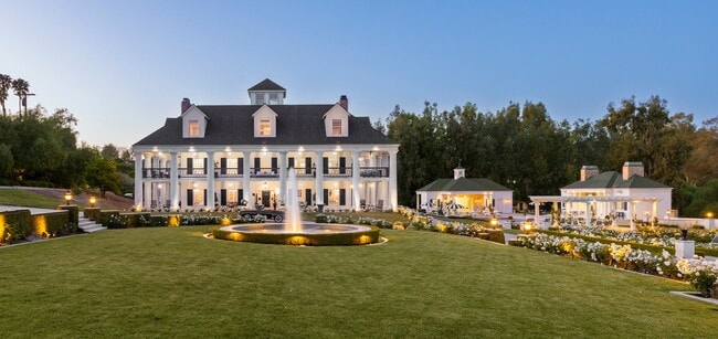
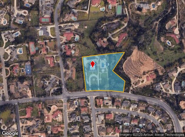
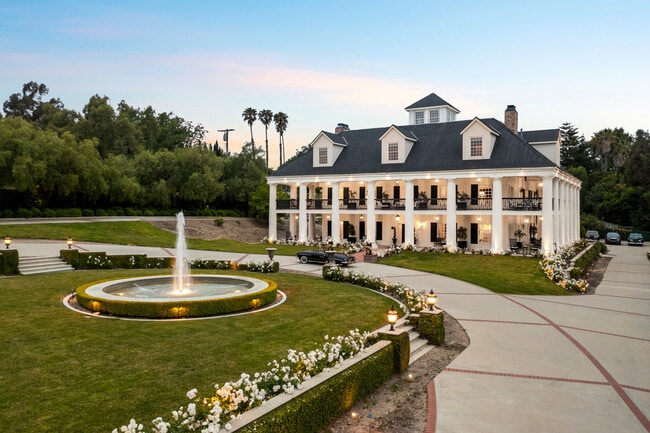
This Property Is For Sale
Property Detail
85 Crestview Ave
152-0-160-085
Rancho Las Posas Estates Unit #1
Sfr
MAP 18 PG 22 LOT 508
X
Ventura
06111C0927F
California
2024
3.38 AC
2025
Camarillo/Point Mugu
005204
Los Angeles
9,290 SF
Oxnard-Thousand Oaks-Ventura, CA
NEARBY LISTINGS FOR SALE OR LEASE
DEMOGRAPHICS near 85 Crestview Ave
1 mile
3 mile
5 mile
2024 Total Population
12,954
45,469
87,117
2029 Population
13,000
45,223
86,431
Pop Growth 2024-2029
+ 0.36%
(0.54%)
(0.79%)
Average Age
41
42
41
2024 Total Households
4,913
16,756
30,233
HH Growth 2024-2029
+ 0.14%
(0.72%)
(0.87%)
Median Household Inc
$117,348
$112,470
$116,758
Avg Household Size
2.60
2.60
2.80
2024 Avg HH Vehicles
2.00
2.00
2.00
Median Home Value
$893,098
$832,508
$808,601
Median Year Built
1991
1976
1980
Nearby Places
Map Layers
Map Styles
 Street
 Aerial
Transit
 Traffic
 Biking
Places
Listings with unknown addresses are not visible on the map
- Restaurants
- Banks
- Shops
- Fitness
- Groceries
PUBLIC TRANSPORTATION
COMMUTER RAIL
Camarillo (Ventura County Line - Southern California Regional Rail Authority (Metrolink))
Drive
Walk
Distance
Camarillo (Ventura County Line - Southern California Regional Rail Authority (Metrolink))
6 min
3.3 mi
Drive
Walk
Distance
14 min
9.5 mi
Freight Ports
The Port of Hueneme
Drive
Walk
Distance
The Port of Hueneme
19 min
11.1 mi
Nearby Properties
Address
Land Use
TOTAL SIZE
Lot Size
Zoning
Address
Land Use
TOTAL SIZE
Lot Size
Zoning
15.13 AC
Address
Land Use
TOTAL SIZE
Lot Size
Zoning
19,288 SF
24.55 AC
CPD
Address
Land Use
TOTAL SIZE
Lot Size
Zoning
10.59 AC
Address
Land Use
TOTAL SIZE
Lot Size
Zoning
72,165 SF
24.05 AC
L-M
Address
Land Use
TOTAL SIZE
Lot Size
Zoning
33,261 SF
36.25 AC
Address
Land Use
TOTAL SIZE
Lot Size
Zoning
67,766 SF
19.31 AC
M2
Address
Land Use
TOTAL SIZE
Lot Size
Zoning
Address
Land Use
TOTAL SIZE
Lot Size
Zoning
45,587 SF
18.30 AC
Address
Land Use
TOTAL SIZE
Lot Size
Zoning
150,320 SF
6.22 AC
Address
Land Use
TOTAL SIZE
Lot Size
Zoning
123,752 SF
5.98 AC
RPD
Address
Land Use
TOTAL SIZE
Lot Size
Zoning
3.31 AC
Address
Land Use
TOTAL SIZE
Lot Size
Zoning
191,193 SF
31.89 AC
M1
Address
Land Use
TOTAL SIZE
Lot Size
Zoning
13.99 AC
Address
Land Use
TOTAL SIZE
Lot Size
Zoning
39,607 SF
10.81 AC
LM
Address
Land Use
TOTAL SIZE
Lot Size
Zoning
19.69 AC
Address
Land Use
TOTAL SIZE
Lot Size
Zoning
84,518 SF
4.71 AC
RPD
Address
Land Use
TOTAL SIZE
Lot Size
Zoning
48,546 SF
4.01 AC
M1
Address
Land Use
TOTAL SIZE
Lot Size
Zoning
77,837 SF
6.46 AC
Address
Land Use
TOTAL SIZE
Lot Size
Zoning
60,511 SF
2.95 AC
RPD30
Address
Land Use
TOTAL SIZE
Lot Size
Zoning
2.66 AC
Address
Land Use
TOTAL SIZE
Lot Size
Zoning
66,715 SF
4.07 AC
Address
Land Use
TOTAL SIZE
Lot Size
Zoning
3.08 AC
Address
Land Use
TOTAL SIZE
Lot Size
Zoning
117,342 SF
7.20 AC
Address
Land Use
TOTAL SIZE
Lot Size
Zoning
1,568 SF
9.87 AC
CPD
Address
Land Use
TOTAL SIZE
Lot Size
Zoning
114,645 SF
5.29 AC
RPD
Address
Land Use
TOTAL SIZE
Lot Size
Zoning
4.76 AC
Address
Land Use
TOTAL SIZE
Lot Size
Zoning
Address
Land Use
TOTAL SIZE
Lot Size
Zoning
66,315 SF
2.37 AC
CPD
Address
Land Use
TOTAL SIZE
Lot Size
Zoning
58,169 SF
3.55 AC
Address
Land Use
TOTAL SIZE
Lot Size
Zoning
60,952 SF
15.59 AC
The World's #1 Commercial Real Estate Marketplace
Connect with us
© 2026 CoStar Group
The information above has been obtained from sources believed reliable. While we do not doubt its accuracy we have not verified it and make no guarantee, warranty or representation about it. It is your responsibility to independently confirm its accuracy and completeness. Any projections, opinions, assumptions, or estimates used are for example only and do not represent the current or future performance of the property. The value of this transaction to you depends on tax and other factors which should be evaluated by your tax, financial, and legal advisors. You and your advisors should conduct a careful, independent investigation of the property to determine to your satisfaction the suitability of the property for your needs.