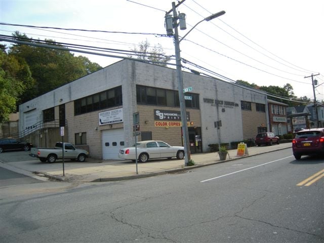
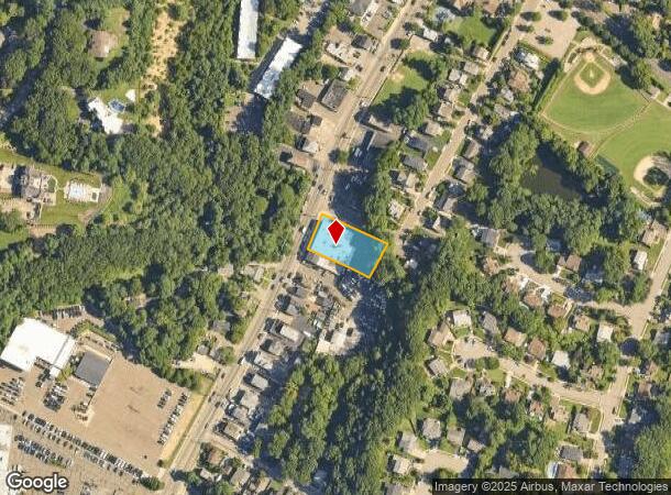
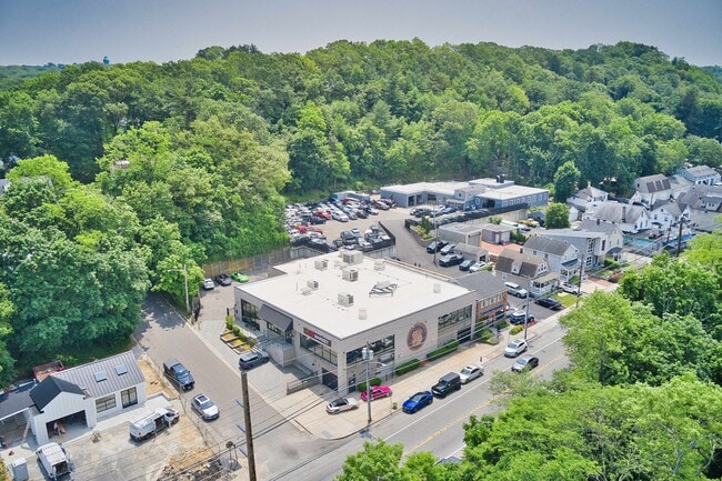
Property Record
85 Pine Hollow Rd, Oyster Bay, NY 11771
Current Lease Availabilities
NEARBY LISTINGS FOR SALE OR LEASE
-
-
View all Oyster Bay listings for lease on LoopNet.com
Property Detail
85 Pine Hollow Rd
2489-27-K-00-0235-0
TOWN #3 SCH DIST 009
Librarymuseum
Nassau
X
New York
36059C0131G
235
2025
0.44 AC
2025
Northern Nassau
518000
Long Island (New York)
27,660 SF
Nassau County-Suffolk County, NY
DEMOGRAPHICS near 85 Pine Hollow Rd
1 Mile
3 Mile
5 Mile
2024 Total Population
8,608
22,748
89,996
2029 Population
8,449
22,436
88,857
Pop Growth 2024-2029
(1.85%)
(1.37%)
(1.27%)
Average Age
43
43
43
2024 Total Households
3,319
7,864
30,103
HH Growth 2024-2029
(1.87%)
(1.53%)
(1.40%)
Median Household Inc
$100,561
$164,268
$149,228
Avg Household Size
2.50
2.80
2.90
2024 Avg HH Vehicles
2.00
2.00
2.00
Median Home Value
$763,070
$942,795
$858,470
Median Year Built
1961
1962
1961
Nearby Places
- Restaurants
- Banks
- Shops
- Fitness
- Groceries
PUBLIC TRANSPORTATION
COMMUTER RAIL
Oyster Bay Station (Oyster Bay Branch - Long Island Rail Road)
DRIVE
WALK
Distance
Oyster Bay Station (Oyster Bay Branch - Long Island Rail Road)
2 min
20 min
1.0 mi
Syosset Station (Port Jefferson Branch - Long Island Rail Road)
DRIVE
WALK
Distance
Syosset Station (Port Jefferson Branch - Long Island Rail Road)
8 min
4.2 mi
AIRPORT
LaGuardia
DRIVE
WALK
Distance
LaGuardia
38 min
24.4 mi
John F Kennedy International
DRIVE
WALK
Distance
John F Kennedy International
40 min
26.2 mi
Westchester County
DRIVE
WALK
Distance
Westchester County
67 min
43.3 mi
Freight Ports
NY - Red Hook Container Terminal
DRIVE
WALK
Distance
NY - Red Hook Container Terminal
49 min
32.5 mi
Nearby Properties
Address
Land Use
TOTAL SIZE
Lot Size
Zoning
Address
Land Use
TOTAL SIZE
Lot Size
Zoning
175,272 SF
209.20 AC
Address
Land Use
TOTAL SIZE
Lot Size
Zoning
23,629 SF
44.63 AC
Address
Land Use
TOTAL SIZE
Lot Size
Zoning
20,000 SF
58.45 AC
Address
Land Use
TOTAL SIZE
Lot Size
Zoning
800 SF
45.25 AC
Address
Land Use
TOTAL SIZE
Lot Size
Zoning
105.79 AC
Address
Land Use
TOTAL SIZE
Lot Size
Zoning
75,253 SF
44.28 AC
Address
Land Use
TOTAL SIZE
Lot Size
Zoning
160 SF
241.23 AC
Address
Land Use
TOTAL SIZE
Lot Size
Zoning
3,020 SF
46.45 AC
Address
Land Use
TOTAL SIZE
Lot Size
Zoning
8.59 AC
Address
Land Use
TOTAL SIZE
Lot Size
Zoning
534,840 SF
26.15 AC
Address
Land Use
TOTAL SIZE
Lot Size
Zoning
29,574 SF
174.23 AC
Address
Land Use
TOTAL SIZE
Lot Size
Zoning
6,702 SF
35.04 AC
Address
Land Use
TOTAL SIZE
Lot Size
Zoning
66,061 SF
18.79 AC
Address
Land Use
TOTAL SIZE
Lot Size
Zoning
83.59 AC
Address
Land Use
TOTAL SIZE
Lot Size
Zoning
43.21 AC
Address
Land Use
TOTAL SIZE
Lot Size
Zoning
3,960 SF
39.54 AC
Address
Land Use
TOTAL SIZE
Lot Size
Zoning
18,430 SF
31.94 AC
Address
Land Use
TOTAL SIZE
Lot Size
Zoning
858 SF
73.93 AC
Address
Land Use
TOTAL SIZE
Lot Size
Zoning
3,600 SF
32.85 AC
Address
Land Use
TOTAL SIZE
Lot Size
Zoning
31,172 SF
1.49 AC
Address
Land Use
TOTAL SIZE
Lot Size
Zoning
16.15 AC
Address
Land Use
TOTAL SIZE
Lot Size
Zoning
14.90 AC
Address
Land Use
TOTAL SIZE
Lot Size
Zoning
47,957 SF
8.94 AC
Address
Land Use
TOTAL SIZE
Lot Size
Zoning
14.70 AC
Address
Land Use
TOTAL SIZE
Lot Size
Zoning
750 SF
13.34 AC
Address
Land Use
TOTAL SIZE
Lot Size
Zoning
3,545 SF
25.63 AC
Address
Land Use
TOTAL SIZE
Lot Size
Zoning
7,586 SF
10.49 AC
Address
Land Use
TOTAL SIZE
Lot Size
Zoning
28,596 SF
59.79 AC
Address
Land Use
TOTAL SIZE
Lot Size
Zoning
1,652 SF
11.22 AC
Address
Land Use
TOTAL SIZE
Lot Size
Zoning
1,822 SF
12.73 AC
The World's #1 Commercial Real Estate Marketplace
Connect with us
© 2025 CoStar Group
The information above has been obtained from sources believed reliable. While we do not doubt its accuracy we have not verified it and make no guarantee, warranty or representation about it. It is your responsibility to independently confirm its accuracy and completeness. Any projections, opinions, assumptions, or estimates used are for example only and do not represent the current or future performance of the property. The value of this transaction to you depends on tax and other factors which should be evaluated by your tax, financial, and legal advisors. You and your advisors should conduct a careful, independent investigation of the property to determine to your satisfaction the suitability of the property for your needs.