Property Record
85 Princeton Rd, Fitchburg, MA 01420
NEARBY LISTINGS FOR SALE OR LEASE
Property Detail
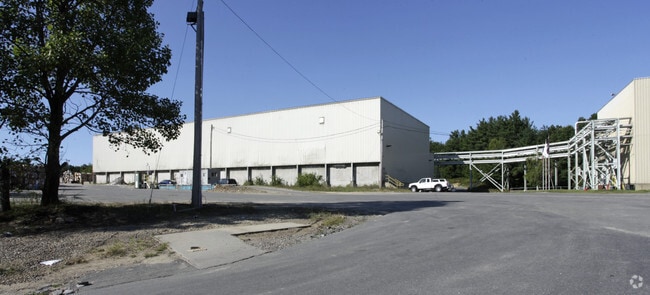
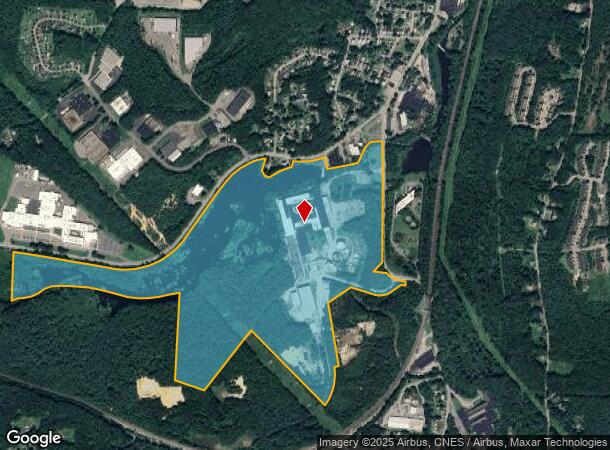
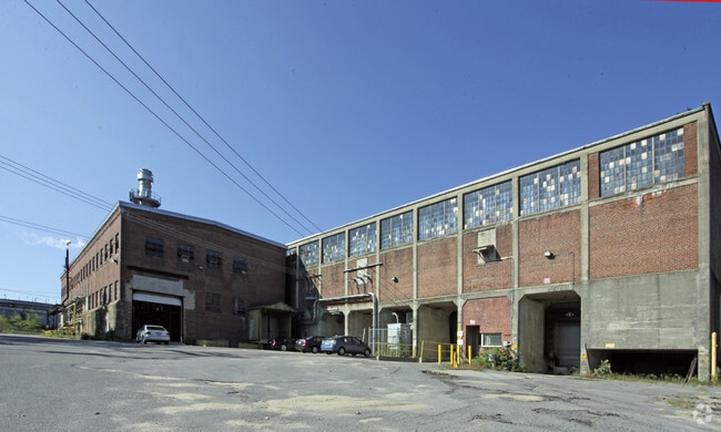
85 Princeton Rd
FITC-000000-W000011
Worcester
Industrialgeneral
Massachusetts
X
127.30 AC
25027C0261F
Fitchburg/Leominster
2025
Boston
2025
Worcester, MA
710601
DEMOGRAPHICS near 85 Princeton Rd
1 Mile
3 Mile
5 Mile
2024 Total Population
2,008
25,159
63,280
2029 Population
2,004
25,078
63,108
Pop Growth 2024-2029
(0.20%)
(0.32%)
(0.27%)
Average Age
41
40
40
2024 Total Households
795
9,819
24,770
HH Growth 2024-2029
(0.25%)
(0.38%)
(0.27%)
Median Household Inc
$85,869
$76,445
$70,950
Avg Household Size
2.50
2.50
2.40
2024 Avg HH Vehicles
2.00
2.00
2.00
Median Home Value
$273,818
$286,676
$304,251
Median Year Built
1957
1957
1958
Nearby Places
Map Layers
Map Styles
 Street
 Aerial
- Restaurants
- Banks
- Shops
- Fitness
- Groceries
PUBLIC TRANSPORTATION
COMMUTER RAIL
Wachusett (Fitchburg Line - MBTA)
DRIVE
WALK
Distance
Wachusett (Fitchburg Line - MBTA)
4 min
1.2 mi
Fitchburg (Fitchburg/South Acton Line - Massachusetts Bay Transportation Authority Commuter Rail (Purple Line))
DRIVE
WALK
Distance
Fitchburg (Fitchburg/South Acton Line - Massachusetts Bay Transportation Authority Commuter Rail (Purple Line))
11 min
4.2 mi
AIRPORT
Worcester Regional
DRIVE
WALK
Distance
Worcester Regional
46 min
27.7 mi
Freight Ports
Port of Boston
DRIVE
WALK
Distance
Port of Boston
79 min
51.7 mi
Nearby Properties
Address
Land Use
TOTAL SIZE
Lot Size
Zoning
Address
Land Use
TOTAL SIZE
Lot Size
Zoning
39.19 AC
CR
Address
Land Use
TOTAL SIZE
Lot Size
Zoning
276,822 SF
26.98 AC
I
Address
Land Use
TOTAL SIZE
Lot Size
Zoning
12.11 AC
RA
Address
Land Use
TOTAL SIZE
Lot Size
Zoning
114,360 SF
6.10 AC
RA
Address
Land Use
TOTAL SIZE
Lot Size
Zoning
281,196 SF
8.70 AC
AI
Address
Land Use
TOTAL SIZE
Lot Size
Zoning
76,396 SF
1.99 AC
DB
Address
Land Use
TOTAL SIZE
Lot Size
Zoning
99,800 SF
20 AC
RA
Address
Land Use
TOTAL SIZE
Lot Size
Zoning
33,000 SF
0.33 AC
DB
Address
Land Use
TOTAL SIZE
Lot Size
Zoning
113,250 SF
34.55 AC
CR
Address
Land Use
TOTAL SIZE
Lot Size
Zoning
3.65 AC
RC
Address
Land Use
TOTAL SIZE
Lot Size
Zoning
178,154 SF
8.50 AC
AI
Address
Land Use
TOTAL SIZE
Lot Size
Zoning
93,545 SF
1.51 AC
RC
Address
Land Use
TOTAL SIZE
Lot Size
Zoning
22,803 SF
0.42 AC
DB
Address
Land Use
TOTAL SIZE
Lot Size
Zoning
10.17 AC
AI
Address
Land Use
TOTAL SIZE
Lot Size
Zoning
22,792 SF
0.86 AC
DB
Address
Land Use
TOTAL SIZE
Lot Size
Zoning
93,240 SF
0.41 AC
DB
Address
Land Use
TOTAL SIZE
Lot Size
Zoning
56,475 SF
4.26 AC
I
Address
Land Use
TOTAL SIZE
Lot Size
Zoning
87,828 SF
AI
Address
Land Use
TOTAL SIZE
Lot Size
Zoning
72,336 SF
6.42 AC
I
Address
Land Use
TOTAL SIZE
Lot Size
Zoning
111,168 SF
1.51 AC
DB
Address
Land Use
TOTAL SIZE
Lot Size
Zoning
91,941 SF
10.55 AC
I
Address
Land Use
TOTAL SIZE
Lot Size
Zoning
630 SF
308.76 AC
RA
Address
Land Use
TOTAL SIZE
Lot Size
Zoning
4.01 AC
Address
Land Use
TOTAL SIZE
Lot Size
Zoning
21,800 SF
16.48 AC
AI
Address
Land Use
TOTAL SIZE
Lot Size
Zoning
1,187.86 AC
Address
Land Use
TOTAL SIZE
Lot Size
Zoning
99,400 SF
8.58 AC
I
Address
Land Use
TOTAL SIZE
Lot Size
Zoning
4.74 AC
I
Address
Land Use
TOTAL SIZE
Lot Size
Zoning
45.86 AC
Address
Land Use
TOTAL SIZE
Lot Size
Zoning
83,408 SF
6.18 AC
I
The World's #1 Commercial Real Estate Marketplace
Connect with us
© 2026 CoStar Group
The information above has been obtained from sources believed reliable. While we do not doubt its accuracy we have not verified it and make no guarantee, warranty or representation about it. It is your responsibility to independently confirm its accuracy and completeness. Any projections, opinions, assumptions, or estimates used are for example only and do not represent the current or future performance of the property. The value of this transaction to you depends on tax and other factors which should be evaluated by your tax, financial, and legal advisors. You and your advisors should conduct a careful, independent investigation of the property to determine to your satisfaction the suitability of the property for your needs.