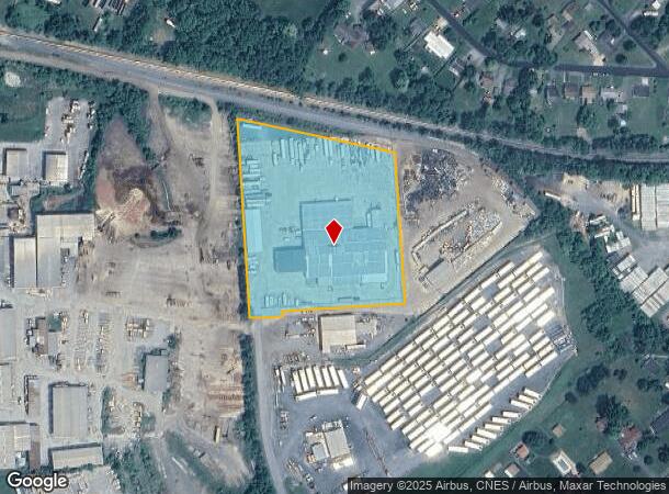
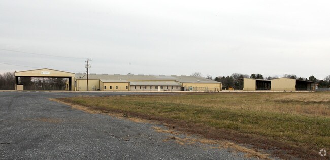
Property Record
85 Shoffner Ln, Fishersville, VA 22939

NEARBY LISTINGS FOR SALE OR LEASE
Property Detail
85 Shoffner Ln
067-107E
Fishersville
Warehouse
67-107E NEAR FISHERSVILLE ON E SIDE OF RT 642 4.295AC
X
Augusta
51125C0025C
Virginia
2025
4.30 AC
2025
Staunton & Harrisonburg
070602
Other Market Areas
35,395 SF
Staunton-Waynesboro, VA
DEMOGRAPHICS near 85 Shoffner Ln
1 Mile
3 Mile
5 Mile
2024 Total Population
3,771
13,007
35,237
2029 Population
3,954
13,538
36,935
Pop Growth 2024-2029
+ 4.85%
+ 4.08%
+ 4.82%
Average Age
43
44
43
2024 Total Households
1,482
5,153
14,726
HH Growth 2024-2029
+ 5.26%
+ 4.33%
+ 4.94%
Median Household Inc
$60,333
$67,759
$59,602
Avg Household Size
2.40
2.40
2.30
2024 Avg HH Vehicles
2.00
2.00
2.00
Median Home Value
$273,499
$270,767
$260,409
Median Year Built
2006
1999
1989
Nearby Places
Map Layers
Map Styles
 Street
 Aerial
- Restaurants
- Banks
- Shops
- Fitness
- Groceries
PUBLIC TRANSPORTATION
COMMUTER RAIL
DRIVE
WALK
Distance
14 min
7.4 mi
AIRPORT
Charlottesville-Albemarle
DRIVE
WALK
Distance
Charlottesville-Albemarle
55 min
39.7 mi
Nearby Properties
Address
Land Use
TOTAL SIZE
Lot Size
Zoning
Address
Land Use
TOTAL SIZE
Lot Size
Zoning
35,328 SF
100.10 AC
GENERAL IN
Address
Land Use
TOTAL SIZE
Lot Size
Zoning
422,707 SF
53.88 AC
GENERAL BU
Address
Land Use
TOTAL SIZE
Lot Size
Zoning
103,815 SF
144.63 AC
GENERAL AG
Address
Land Use
TOTAL SIZE
Lot Size
Zoning
17,442 SF
22.14 AC
MULTI-FAMI
Address
Land Use
TOTAL SIZE
Lot Size
Zoning
17,442 SF
7.16 AC
MULTI-FAMI
Address
Land Use
TOTAL SIZE
Lot Size
Zoning
98,326 SF
14.62 AC
GENERAL AG
Address
Land Use
TOTAL SIZE
Lot Size
Zoning
54,796 SF
40 AC
MULTI-FAMI
Address
Land Use
TOTAL SIZE
Lot Size
Zoning
71,141 SF
21.91 AC
GENERAL BU
Address
Land Use
TOTAL SIZE
Lot Size
Zoning
58,660 SF
6.50 AC
GENERAL BU
Address
Land Use
TOTAL SIZE
Lot Size
Zoning
138,341 SF
18.94 AC
H-B
Address
Land Use
TOTAL SIZE
Lot Size
Zoning
15,304 SF
13.39 AC
RS-12
Address
Land Use
TOTAL SIZE
Lot Size
Zoning
56,516 SF
8.29 AC
GENERAL BU
Address
Land Use
TOTAL SIZE
Lot Size
Zoning
96,070 SF
27.10 AC
H-B
Address
Land Use
TOTAL SIZE
Lot Size
Zoning
39,748 SF
28.84 AC
GENERAL BU
Address
Land Use
TOTAL SIZE
Lot Size
Zoning
44,378 SF
156.80 AC
GENERAL BU
Address
Land Use
TOTAL SIZE
Lot Size
Zoning
48,725 SF
9.21 AC
GENERAL BU
Address
Land Use
TOTAL SIZE
Lot Size
Zoning
54,400 SF
9.33 AC
H-B
Address
Land Use
TOTAL SIZE
Lot Size
Zoning
23,826 SF
4.56 AC
GENERAL BU
Address
Land Use
TOTAL SIZE
Lot Size
Zoning
29,520 SF
33.28 AC
GENERAL IN
Address
Land Use
TOTAL SIZE
Lot Size
Zoning
42,343 SF
2.53 AC
GENERAL BU
Address
Land Use
TOTAL SIZE
Lot Size
Zoning
37,080 SF
12 AC
MULTI-FAMI
Address
Land Use
TOTAL SIZE
Lot Size
Zoning
58,706 SF
8.44 AC
GENERAL BU
Address
Land Use
TOTAL SIZE
Lot Size
Zoning
7,178 SF
4.16 AC
R-MF
Address
Land Use
TOTAL SIZE
Lot Size
Zoning
30,844 SF
4.72 AC
H-B
Address
Land Use
TOTAL SIZE
Lot Size
Zoning
136,214 SF
6.97 AC
GENERAL IN
Address
Land Use
TOTAL SIZE
Lot Size
Zoning
28,652 SF
5 AC
GENERAL AG
Address
Land Use
TOTAL SIZE
Lot Size
Zoning
8,450 SF
3.77 AC
MULTI-FAMI
Address
Land Use
TOTAL SIZE
Lot Size
Zoning
2,012 SF
3.92 AC
PLANNED UN
Address
Land Use
TOTAL SIZE
Lot Size
Zoning
1,606 SF
3.24 AC
PLANNED UN
The World's #1 Commercial Real Estate Marketplace
Connect with us
© 2026 CoStar Group
The information above has been obtained from sources believed reliable. While we do not doubt its accuracy we have not verified it and make no guarantee, warranty or representation about it. It is your responsibility to independently confirm its accuracy and completeness. Any projections, opinions, assumptions, or estimates used are for example only and do not represent the current or future performance of the property. The value of this transaction to you depends on tax and other factors which should be evaluated by your tax, financial, and legal advisors. You and your advisors should conduct a careful, independent investigation of the property to determine to your satisfaction the suitability of the property for your needs.