Property Record
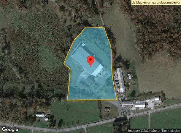
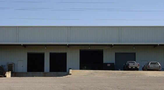
85 Starbridge Rd, Murrayville, GA 30564

NEARBY LISTINGS FOR SALE OR LEASE
Property Detail
85 Starbridge Rd
110-000-022-000
Rural C 1 25 K Ac
Manufacturinglight
7.59 ACS LL 97 LD 1-ORG HAB
X
Lumpkin
13187C0170D
Georgia
2024
7.59 AC
2024
Alpharetta/North
960103
Other Market Areas
56,200 SF
Atlanta-Sandy Springs-Roswell, GA
DEMOGRAPHICS near 85 Starbridge Rd
1 Mile
3 Mile
5 Mile
2024 Total Population
563
4,500
13,262
2029 Population
625
5,010
14,732
Pop Growth 2024-2029
+ 11.01%
+ 11.33%
+ 11.08%
Average Age
42
42
42
2024 Total Households
210
1,675
4,958
HH Growth 2024-2029
+ 10.95%
+ 11.16%
+ 10.95%
Median Household Inc
$60,300
$63,151
$64,467
Avg Household Size
2.60
2.60
2.60
2024 Avg HH Vehicles
2.00
2.00
2.00
Median Home Value
$274,467
$262,121
$255,243
Median Year Built
1994
1995
1995
Nearby Places
Map Layers
Map Styles
 Street
 Aerial
- Restaurants
- Banks
- Shops
- Fitness
- Groceries
Nearby Properties
Address
Land Use
TOTAL SIZE
Lot Size
Zoning
Address
Land Use
TOTAL SIZE
Lot Size
Zoning
797.73 AC
AP
Address
Land Use
TOTAL SIZE
Lot Size
Zoning
59,100 SF
15.29 AC
GC
Address
Land Use
TOTAL SIZE
Lot Size
Zoning
401.48 AC
RP
Address
Land Use
TOTAL SIZE
Lot Size
Zoning
276.75 AC
RG
Address
Land Use
TOTAL SIZE
Lot Size
Zoning
4,600 SF
5.38 AC
GC
Address
Land Use
TOTAL SIZE
Lot Size
Zoning
176.59 AC
GC
Address
Land Use
TOTAL SIZE
Lot Size
Zoning
111.61 AC
RP
Address
Land Use
TOTAL SIZE
Lot Size
Zoning
3,880 SF
14.36 AC
PI
Address
Land Use
TOTAL SIZE
Lot Size
Zoning
154.33 AC
RP
Address
Land Use
TOTAL SIZE
Lot Size
Zoning
160 AC
RP
Address
Land Use
TOTAL SIZE
Lot Size
Zoning
71.39 AC
RG
Address
Land Use
TOTAL SIZE
Lot Size
Zoning
123.10 AC
RG
Address
Land Use
TOTAL SIZE
Lot Size
Zoning
117.37 AC
RG
Address
Land Use
TOTAL SIZE
Lot Size
Zoning
136.67 AC
AP
Address
Land Use
TOTAL SIZE
Lot Size
Zoning
6,300 SF
4.34 AC
I
Address
Land Use
TOTAL SIZE
Lot Size
Zoning
7,840 SF
4.98 AC
RG
Address
Land Use
TOTAL SIZE
Lot Size
Zoning
97.82 AC
RG
Address
Land Use
TOTAL SIZE
Lot Size
Zoning
103.43 AC
GC
Address
Land Use
TOTAL SIZE
Lot Size
Zoning
91.21 AC
RG
Address
Land Use
TOTAL SIZE
Lot Size
Zoning
55.45 AC
RG
Address
Land Use
TOTAL SIZE
Lot Size
Zoning
1,295 SF
8.28 AC
RG
Address
Land Use
TOTAL SIZE
Lot Size
Zoning
134.95 AC
RP
Address
Land Use
TOTAL SIZE
Lot Size
Zoning
63.08 AC
GC
Address
Land Use
TOTAL SIZE
Lot Size
Zoning
6,852 SF
1.02 AC
GC
Address
Land Use
TOTAL SIZE
Lot Size
Zoning
25,650 SF
1.92 AC
GC
Address
Land Use
TOTAL SIZE
Lot Size
Zoning
81.91 AC
GC
Address
Land Use
TOTAL SIZE
Lot Size
Zoning
9,796 SF
4.83 AC
I
Address
Land Use
TOTAL SIZE
Lot Size
Zoning
75.64 AC
RP
Address
Land Use
TOTAL SIZE
Lot Size
Zoning
5,328 SF
2.13 AC
I
The World's #1 Commercial Real Estate Marketplace
Connect with us
© 2026 CoStar Group
The information above has been obtained from sources believed reliable. While we do not doubt its accuracy we have not verified it and make no guarantee, warranty or representation about it. It is your responsibility to independently confirm its accuracy and completeness. Any projections, opinions, assumptions, or estimates used are for example only and do not represent the current or future performance of the property. The value of this transaction to you depends on tax and other factors which should be evaluated by your tax, financial, and legal advisors. You and your advisors should conduct a careful, independent investigation of the property to determine to your satisfaction the suitability of the property for your needs.