Property Record
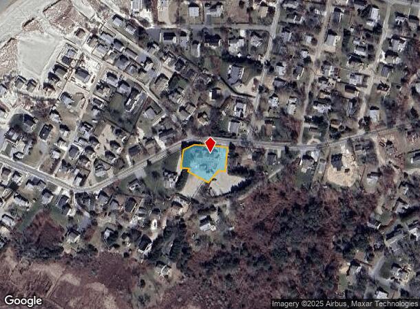
85 Taunton Ave, Dennis, MA 02638
NEARBY LISTINGS FOR SALE OR LEASE
-
-
View all Dennis listings for sale on LoopNet.com
Property Detail
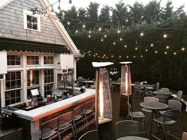
85 Taunton Ave
Restaurantbuilding
Barnstable
X
Massachusetts
25001C0576J
0.52 AC
2025
Cape Cod
2025
Other Market Areas
011300
Barnstable Town, MA
5,164 SF
DENN-000344-000000-000151
DEMOGRAPHICS near 85 Taunton Ave
1 Mile
3 Mile
5 Mile
2024 Total Population
696
9,779
26,356
2029 Population
747
10,060
26,925
Pop Growth 2024-2029
+ 7.33%
+ 2.87%
+ 2.16%
Average Age
61
55
52
2024 Total Households
383
4,729
12,119
HH Growth 2024-2029
+ 7.05%
+ 2.69%
+ 1.91%
Median Household Inc
$122,880
$98,848
$90,604
Avg Household Size
1.80
2.00
2.10
2024 Avg HH Vehicles
2.00
2.00
2.00
Median Home Value
$885,541
$519,406
$463,288
Median Year Built
1975
1976
1976
Nearby Places
Map Layers
Map Styles
 Street
 Aerial
- Restaurants
- Banks
- Shops
- Fitness
- Groceries
PUBLIC TRANSPORTATION
COMMUTER RAIL
DRIVE
WALK
Distance
18 min
9.3 mi
AIRPORT
Nantucket Memorial
DRIVE
WALK
Distance
Nantucket Memorial
168 min
43.1 mi
Martha's Vineyard
DRIVE
WALK
Distance
Martha's Vineyard
121 min
47.7 mi
Freight Ports
Port of New Bedford Harbor
DRIVE
WALK
Distance
Port of New Bedford Harbor
81 min
56.1 mi
SALE & LEASE HISTORY
LISTING DATE
SALE/LEASE

Jan 10, 2019
For Sale
Nearby Properties
Address
Land Use
TOTAL SIZE
Lot Size
Zoning
Address
Land Use
TOTAL SIZE
Lot Size
Zoning
1,228 SF
10.54 AC
Address
Land Use
TOTAL SIZE
Lot Size
Zoning
5.11 AC
R-60
Address
Land Use
TOTAL SIZE
Lot Size
Zoning
2.93 AC
R-60
Address
Land Use
TOTAL SIZE
Lot Size
Zoning
5.42 AC
Address
Land Use
TOTAL SIZE
Lot Size
Zoning
163.08 AC
Address
Land Use
TOTAL SIZE
Lot Size
Zoning
6.12 AC
R-60
Address
Land Use
TOTAL SIZE
Lot Size
Zoning
0.69 AC
R-40
Address
Land Use
TOTAL SIZE
Lot Size
Zoning
0.95 AC
Address
Land Use
TOTAL SIZE
Lot Size
Zoning
1,636 SF
10.60 AC
Address
Land Use
TOTAL SIZE
Lot Size
Zoning
6.70 AC
R-60
Address
Land Use
TOTAL SIZE
Lot Size
Zoning
0.65 AC
Address
Land Use
TOTAL SIZE
Lot Size
Zoning
1.18 AC
Address
Land Use
TOTAL SIZE
Lot Size
Zoning
6,281 SF
2.56 AC
Address
Land Use
TOTAL SIZE
Lot Size
Zoning
3.56 AC
R-60
Address
Land Use
TOTAL SIZE
Lot Size
Zoning
93.85 AC
Address
Land Use
TOTAL SIZE
Lot Size
Zoning
Address
Land Use
TOTAL SIZE
Lot Size
Zoning
3,668 SF
0.51 AC
Address
Land Use
TOTAL SIZE
Lot Size
Zoning
834 SF
39 AC
Address
Land Use
TOTAL SIZE
Lot Size
Zoning
1,948 SF
2.14 AC
Address
Land Use
TOTAL SIZE
Lot Size
Zoning
7,975 SF
4.58 AC
Address
Land Use
TOTAL SIZE
Lot Size
Zoning
3.89 AC
R-60
Address
Land Use
TOTAL SIZE
Lot Size
Zoning
0.33 AC
Address
Land Use
TOTAL SIZE
Lot Size
Zoning
0.94 AC
Address
Land Use
TOTAL SIZE
Lot Size
Zoning
5,073 SF
15 AC
Address
Land Use
TOTAL SIZE
Lot Size
Zoning
10,588 SF
13.14 AC
Address
Land Use
TOTAL SIZE
Lot Size
Zoning
215.69 AC
Address
Land Use
TOTAL SIZE
Lot Size
Zoning
14.26 AC
Address
Land Use
TOTAL SIZE
Lot Size
Zoning
1,780 SF
0.34 AC
Address
Land Use
TOTAL SIZE
Lot Size
Zoning
Address
Land Use
TOTAL SIZE
Lot Size
Zoning
1,042 SF
2.30 AC
The World's #1 Commercial Real Estate Marketplace
Connect with us
© 2025 CoStar Group
The information above has been obtained from sources believed reliable. While we do not doubt its accuracy we have not verified it and make no guarantee, warranty or representation about it. It is your responsibility to independently confirm its accuracy and completeness. Any projections, opinions, assumptions, or estimates used are for example only and do not represent the current or future performance of the property. The value of this transaction to you depends on tax and other factors which should be evaluated by your tax, financial, and legal advisors. You and your advisors should conduct a careful, independent investigation of the property to determine to your satisfaction the suitability of the property for your needs.