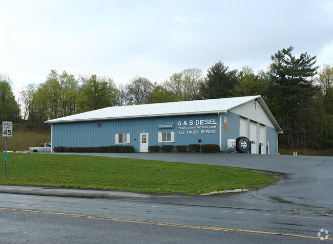
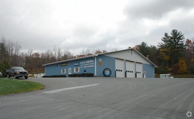
Property Record
850 Hoosick Rd, Troy, NY 12180

NEARBY LISTINGS FOR SALE OR LEASE
Property Detail
850 Hoosick Rd
2200-091-2-26.21
A & S DIESEL
Gasolinefuelbulkstorage
Rensselaer
ARE
New York
36083C0119D
26.021
2025
2.88 AC
2024
Outer Rensselaer County
052004
Albany/Schenectady/Troy
66,320 SF
Albany-Schenectady-Troy, NY
DEMOGRAPHICS near 850 Hoosick Rd
1 Mile
3 Mile
5 Mile
2024 Total Population
2,621
35,790
104,453
2029 Population
2,654
35,522
102,770
Pop Growth 2024-2029
+ 1.26%
(0.75%)
(1.61%)
Average Age
44
39
39
2024 Total Households
1,222
14,521
45,255
HH Growth 2024-2029
+ 1.31%
(0.79%)
(1.71%)
Median Household Inc
$98,369
$54,954
$59,078
Avg Household Size
2.10
2.20
2.10
2024 Avg HH Vehicles
2.00
1.00
1.00
Median Home Value
$262,692
$204,786
$189,933
Median Year Built
1987
1952
1950
Nearby Places
Map Layers
Map Styles
 Street
 Aerial
- Restaurants
- Banks
- Shops
- Fitness
- Groceries
PUBLIC TRANSPORTATION
AIRPORT
Albany International
DRIVE
WALK
Distance
Albany International
18 min
10.2 mi
Freight Ports
Albany, NY Port
DRIVE
WALK
Distance
Albany, NY Port
23 min
13.0 mi
SALE & LEASE HISTORY
LISTING DATE
SALE/LEASE

May 11, 2017
For Sale
Nearby Properties
Address
Land Use
TOTAL SIZE
Lot Size
Zoning
Address
Land Use
TOTAL SIZE
Lot Size
Zoning
34,971 SF
108.68 AC
CI
Address
Land Use
TOTAL SIZE
Lot Size
Zoning
313,907 SF
8.23 AC
CI
Address
Land Use
TOTAL SIZE
Lot Size
Zoning
9,643 SF
5.36 AC
CI
Address
Land Use
TOTAL SIZE
Lot Size
Zoning
Address
Land Use
TOTAL SIZE
Lot Size
Zoning
5,000 SF
48.44 AC
CR
Address
Land Use
TOTAL SIZE
Lot Size
Zoning
35,392 SF
73.57 AC
CI
Address
Land Use
TOTAL SIZE
Lot Size
Zoning
413,006 SF
37.94 AC
CI
Address
Land Use
TOTAL SIZE
Lot Size
Zoning
67,335 SF
65.54 AC
CI
Address
Land Use
TOTAL SIZE
Lot Size
Zoning
77,193 SF
28.41 AC
SF
Address
Land Use
TOTAL SIZE
Lot Size
Zoning
Address
Land Use
TOTAL SIZE
Lot Size
Zoning
16,698 SF
46.45 AC
MF
Address
Land Use
TOTAL SIZE
Lot Size
Zoning
113,400 SF
3.40 AC
CI
Address
Land Use
TOTAL SIZE
Lot Size
Zoning
77,928 SF
2.25 AC
WMU
Address
Land Use
TOTAL SIZE
Lot Size
Zoning
1,500 SF
7.01 AC
WMU
Address
Land Use
TOTAL SIZE
Lot Size
Zoning
154,587 SF
3.79 AC
CC
Address
Land Use
TOTAL SIZE
Lot Size
Zoning
3,600 SF
17.54 AC
MF
Address
Land Use
TOTAL SIZE
Lot Size
Zoning
63,828 SF
2.74 AC
CI
Address
Land Use
TOTAL SIZE
Lot Size
Zoning
3,202 SF
7.34 AC
CI
Address
Land Use
TOTAL SIZE
Lot Size
Zoning
Address
Land Use
TOTAL SIZE
Lot Size
Zoning
Address
Land Use
TOTAL SIZE
Lot Size
Zoning
135,933 SF
12.17 AC
CC
Address
Land Use
TOTAL SIZE
Lot Size
Zoning
181,839 SF
3.42 AC
DMU
Address
Land Use
TOTAL SIZE
Lot Size
Zoning
95,466 SF
7.64 AC
MF
Address
Land Use
TOTAL SIZE
Lot Size
Zoning
52 AC
CR
Address
Land Use
TOTAL SIZE
Lot Size
Zoning
3,320 SF
215.98 AC
CR
Address
Land Use
TOTAL SIZE
Lot Size
Zoning
116,445 SF
0.76 AC
WMU
Address
Land Use
TOTAL SIZE
Lot Size
Zoning
4,200 SF
12.21 AC
MF
Address
Land Use
TOTAL SIZE
Lot Size
Zoning
Address
Land Use
TOTAL SIZE
Lot Size
Zoning
31,746 SF
14.19 AC
I
Address
Land Use
TOTAL SIZE
Lot Size
Zoning
53,148 SF
3.17 AC
MU2
The World's #1 Commercial Real Estate Marketplace
Connect with us
© 2025 CoStar Group
The information above has been obtained from sources believed reliable. While we do not doubt its accuracy we have not verified it and make no guarantee, warranty or representation about it. It is your responsibility to independently confirm its accuracy and completeness. Any projections, opinions, assumptions, or estimates used are for example only and do not represent the current or future performance of the property. The value of this transaction to you depends on tax and other factors which should be evaluated by your tax, financial, and legal advisors. You and your advisors should conduct a careful, independent investigation of the property to determine to your satisfaction the suitability of the property for your needs.