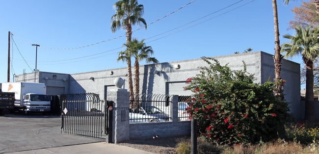
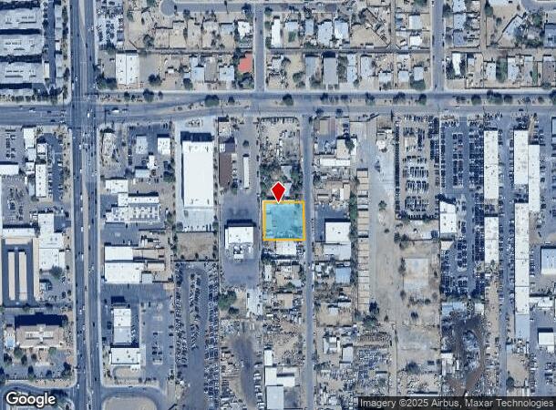
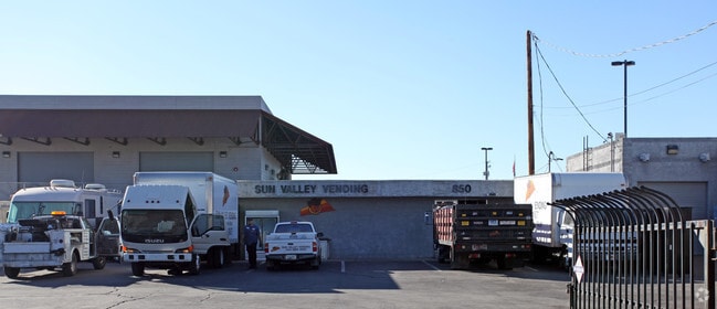
Property Record
850 N Mary St, Tempe, AZ 85288
Current Lease Availabilities
NEARBY LISTINGS FOR SALE OR LEASE
Property Detail
850 N Mary St
Phoenix-Mesa-Scottsdale, AZ
Fruitland Farms 9-16
132-19-029
FRUITLAND FARMS 9-16 MCR 40/07
Warehouse
Maricopa
X
Arizona
04013C2235M
5
2025
0.44 AC
2025
Tempe East
318400
Phoenix
4,368 SF
DEMOGRAPHICS near 850 N Mary St
1 Mile
3 Mile
5 Mile
2024 Total Population
12,953
133,233
349,487
2029 Population
14,385
144,819
380,515
Pop Growth 2024-2029
+ 11.06%
+ 8.70%
+ 8.88%
Average Age
31
34
36
2024 Total Households
5,802
59,331
152,973
HH Growth 2024-2029
+ 11.55%
+ 9.15%
+ 9.29%
Median Household Inc
$73,891
$61,368
$64,089
Avg Household Size
1.90
2.00
2.10
2024 Avg HH Vehicles
2.00
2.00
2.00
Median Home Value
$366,932
$372,446
$389,162
Median Year Built
2000
1984
1980
Nearby Places
- Restaurants
- Banks
- Shops
- Fitness
- Groceries
PUBLIC TRANSPORTATION
AIRPORT
Phoenix Sky Harbor International
DRIVE
WALK
Distance
Phoenix Sky Harbor International
10 min
5.3 mi
Phoenix-Mesa Gateway
DRIVE
WALK
Distance
Phoenix-Mesa Gateway
35 min
24.1 mi
Freight Ports
Port of San Diego
DRIVE
WALK
Distance
Port of San Diego
406 min
364.7 mi
Nearby Properties
Address
Land Use
TOTAL SIZE
Lot Size
Zoning
Address
Land Use
TOTAL SIZE
Lot Size
Zoning
4.59 AC
I-1
Address
Land Use
TOTAL SIZE
Lot Size
Zoning
1,870,689 SF
46.77 AC
I-P
Address
Land Use
TOTAL SIZE
Lot Size
Zoning
75,000 SF
12.19 AC
I-1
Address
Land Use
TOTAL SIZE
Lot Size
Zoning
2.63 AC
I-1
Address
Land Use
TOTAL SIZE
Lot Size
Zoning
Address
Land Use
TOTAL SIZE
Lot Size
Zoning
401,544 SF
64.59 AC
GID
Address
Land Use
TOTAL SIZE
Lot Size
Zoning
2,089,643 SF
33.80 AC
MU-ED
Address
Land Use
TOTAL SIZE
Lot Size
Zoning
1,227,029 SF
7.39 AC
R-6
Address
Land Use
TOTAL SIZE
Lot Size
Zoning
106,575 SF
2.50 AC
I-1
Address
Land Use
TOTAL SIZE
Lot Size
Zoning
1,056,321 SF
35.93 AC
R1-6
Address
Land Use
TOTAL SIZE
Lot Size
Zoning
1,102,629 SF
12.33 AC
R-3
Address
Land Use
TOTAL SIZE
Lot Size
Zoning
2.54 AC
Address
Land Use
TOTAL SIZE
Lot Size
Zoning
649,656 SF
10.19 AC
PAD
Address
Land Use
TOTAL SIZE
Lot Size
Zoning
3.77 AC
PNC
Address
Land Use
TOTAL SIZE
Lot Size
Zoning
571,804 SF
0.98 AC
CSS
Address
Land Use
TOTAL SIZE
Lot Size
Zoning
44,971 SF
2.06 AC
C-R
Address
Land Use
TOTAL SIZE
Lot Size
Zoning
58,061 SF
5.43 AC
C-C
Address
Land Use
TOTAL SIZE
Lot Size
Zoning
697,894 SF
8.43 AC
PAD
Address
Land Use
TOTAL SIZE
Lot Size
Zoning
8.79 AC
PF
Address
Land Use
TOTAL SIZE
Lot Size
Zoning
197,454 SF
18.97 AC
PF
Address
Land Use
TOTAL SIZE
Lot Size
Zoning
511,014 SF
5.01 AC
I-1
Address
Land Use
TOTAL SIZE
Lot Size
Zoning
307,604 SF
37.83 AC
R-7
Address
Land Use
TOTAL SIZE
Lot Size
Zoning
301,376 SF
8.77 AC
PAD
Address
Land Use
TOTAL SIZE
Lot Size
Zoning
688,550 SF
149.95 AC
R-6
Address
Land Use
TOTAL SIZE
Lot Size
Zoning
548,227 SF
1.62 AC
C-G
Address
Land Use
TOTAL SIZE
Lot Size
Zoning
776,898 SF
27.32 AC
C-R
The World's #1 Commercial Real Estate Marketplace
Connect with us
© 2025 CoStar Group
The information above has been obtained from sources believed reliable. While we do not doubt its accuracy we have not verified it and make no guarantee, warranty or representation about it. It is your responsibility to independently confirm its accuracy and completeness. Any projections, opinions, assumptions, or estimates used are for example only and do not represent the current or future performance of the property. The value of this transaction to you depends on tax and other factors which should be evaluated by your tax, financial, and legal advisors. You and your advisors should conduct a careful, independent investigation of the property to determine to your satisfaction the suitability of the property for your needs.