Property Record
850 Scotch Hall Way, Fayetteville, NC 28303
NEARBY LISTINGS FOR SALE OR LEASE
Property Detail
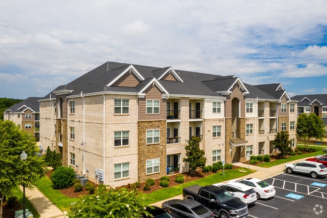
850 Scotch Hall Way
Fayetteville, NC
Plantation At Fayetteville
0409-70-9339
PLANTATION AT FAYETTEVILLE LO:1 SE:01 PL:0135-0184
Apartment
Cumberland
AE
North Carolina
3720040900J
1
2025
27.17 AC
2025
Westover
002200
Fayetteville
2,025 SF
DEMOGRAPHICS near 850 Scotch Hall Way
1 Mile
3 Mile
5 Mile
2024 Total Population
6,302
50,257
130,189
2029 Population
6,393
50,353
130,442
Pop Growth 2024-2029
+ 1.44%
+ 0.19%
+ 0.19%
Average Age
37
34
35
2024 Total Households
2,833
20,182
51,415
HH Growth 2024-2029
+ 1.76%
+ 0.31%
+ 0.18%
Median Household Inc
$53,038
$48,451
$47,539
Avg Household Size
2.10
2.20
2.30
2024 Avg HH Vehicles
2.00
2.00
2.00
Median Home Value
$141,631
$141,349
$146,644
Median Year Built
1981
1980
1978
Nearby Places
Map Layers
Map Styles
 Street
 Aerial
- Restaurants
- Banks
- Shops
- Fitness
- Groceries
PUBLIC TRANSPORTATION
COMMUTER RAIL
Fayetteville Amtrak Station (Palmetto - Amtrak, Silver Meteor - Amtrak)
DRIVE
WALK
Distance
Fayetteville Amtrak Station (Palmetto - Amtrak, Silver Meteor - Amtrak)
12 min
6.8 mi
AIRPORT
Fayetteville Regional/Grannis Field
DRIVE
WALK
Distance
Fayetteville Regional/Grannis Field
15 min
10.3 mi
Freight Ports
Port of Wilmington
DRIVE
WALK
Distance
Port of Wilmington
135 min
97.2 mi
SALE & LEASE HISTORY
LISTING DATE
SALE/LEASE

Jul 03, 2018
For Sale
Nearby Properties
Address
Land Use
TOTAL SIZE
Lot Size
Zoning
Address
Land Use
TOTAL SIZE
Lot Size
Zoning
82.54 AC
BPCZ-BUSI
Address
Land Use
TOTAL SIZE
Lot Size
Zoning
3,641 SF
20.54 AC
MR5
Address
Land Use
TOTAL SIZE
Lot Size
Zoning
2,744 SF
21.34 AC
MR5
Address
Land Use
TOTAL SIZE
Lot Size
Zoning
3,320 SF
16 AC
MR5
Address
Land Use
TOTAL SIZE
Lot Size
Zoning
5,755 SF
23.12 AC
CC-COMMUNI
Address
Land Use
TOTAL SIZE
Lot Size
Zoning
5,210 SF
22.36 AC
MR5
Address
Land Use
TOTAL SIZE
Lot Size
Zoning
1,113 SF
24.36 AC
MR5-MIXED
Address
Land Use
TOTAL SIZE
Lot Size
Zoning
19.46 AC
MR5
Address
Land Use
TOTAL SIZE
Lot Size
Zoning
1,930 SF
20.92 AC
MR5M
Address
Land Use
TOTAL SIZE
Lot Size
Zoning
13.94 AC
CCCZ
Address
Land Use
TOTAL SIZE
Lot Size
Zoning
54,316 SF
28.64 AC
CC
Address
Land Use
TOTAL SIZE
Lot Size
Zoning
3,999 SF
44.59 AC
MR5
Address
Land Use
TOTAL SIZE
Lot Size
Zoning
1,556 SF
15.80 AC
MR5
Address
Land Use
TOTAL SIZE
Lot Size
Zoning
58,704 SF
23.38 AC
CC
Address
Land Use
TOTAL SIZE
Lot Size
Zoning
181,147 SF
24.02 AC
CCCZ
Address
Land Use
TOTAL SIZE
Lot Size
Zoning
4,522 SF
12.59 AC
MR5
Address
Land Use
TOTAL SIZE
Lot Size
Zoning
135,996 SF
14.28 AC
CCCZ
Address
Land Use
TOTAL SIZE
Lot Size
Zoning
38,656 SF
6.53 AC
CC
Address
Land Use
TOTAL SIZE
Lot Size
Zoning
4,582 SF
23.32 AC
NC
Address
Land Use
TOTAL SIZE
Lot Size
Zoning
7,434 SF
5.87 AC
R5CZ
Address
Land Use
TOTAL SIZE
Lot Size
Zoning
4,582 SF
21.10 AC
MR5
Address
Land Use
TOTAL SIZE
Lot Size
Zoning
1,064 SF
9.88 AC
R5C
Address
Land Use
TOTAL SIZE
Lot Size
Zoning
1,682 SF
30.53 AC
CC-COMMUNI
Address
Land Use
TOTAL SIZE
Lot Size
Zoning
2,456 SF
14.24 AC
MR5
Address
Land Use
TOTAL SIZE
Lot Size
Zoning
2,314 SF
21.82 AC
MR5
Address
Land Use
TOTAL SIZE
Lot Size
Zoning
5,112 SF
28.44 AC
CC-COMMUNI
Address
Land Use
TOTAL SIZE
Lot Size
Zoning
48,716 SF
57.88 AC
SF10
Address
Land Use
TOTAL SIZE
Lot Size
Zoning
1,732 SF
13.45 AC
MR5
Address
Land Use
TOTAL SIZE
Lot Size
Zoning
1,039 SF
13.65 AC
MR5
The World's #1 Commercial Real Estate Marketplace
Connect with us
© 2025 CoStar Group
The information above has been obtained from sources believed reliable. While we do not doubt its accuracy we have not verified it and make no guarantee, warranty or representation about it. It is your responsibility to independently confirm its accuracy and completeness. Any projections, opinions, assumptions, or estimates used are for example only and do not represent the current or future performance of the property. The value of this transaction to you depends on tax and other factors which should be evaluated by your tax, financial, and legal advisors. You and your advisors should conduct a careful, independent investigation of the property to determine to your satisfaction the suitability of the property for your needs.