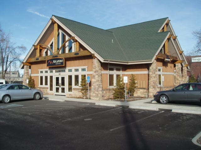
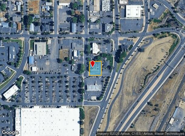
Property Record
850 Sw 7Th St, Redmond, OR 97756


NEARBY LISTINGS FOR SALE OR LEASE
Property Detail
850 Sw 7Th St
Bend, OR
The Redmond Townsite Cos 2Nd Addition To
150677
THE REDMOND TOWNSITE COS 2ND ADDITION TO REDMOND BLOCK 7 LOT 5 & 6 + VAC ST & ALL
Commercialnec
Deschutes
X
Oregon
41017C0325E
5&6
2025
0.33 AC
2025
Deschutes County
000901
Portland
5,681 SF
DEMOGRAPHICS near 850 Sw 7Th St
1 Mile
3 Mile
5 Mile
2024 Total Population
6,266
36,071
42,725
2029 Population
6,998
40,474
47,947
Pop Growth 2024-2029
+ 11.68%
+ 12.21%
+ 12.22%
Average Age
38
39
41
2024 Total Households
2,533
13,741
16,449
HH Growth 2024-2029
+ 11.76%
+ 12.35%
+ 12.40%
Median Household Inc
$60,643
$71,604
$74,052
Avg Household Size
2.40
2.60
2.60
2024 Avg HH Vehicles
2.00
2.00
2.00
Median Home Value
$402,151
$406,358
$435,559
Median Year Built
1981
2000
2000
Nearby Places
Map Layers
Map Styles
 Street
 Aerial
- Restaurants
- Banks
- Shops
- Fitness
- Groceries
PUBLIC TRANSPORTATION
AIRPORT
Roberts Field
DRIVE
WALK
Distance
Roberts Field
5 min
2.1 mi
SALE & LEASE HISTORY
LISTING DATE
SALE/LEASE

Sep 25, 2016
For Lease
Oct 20, 2023
For Lease
Mar 17, 2025
For Lease
Jun 23, 2017
For Sale
Jun 02, 2021
For Sale
Jan 27, 2017
For Lease
Aug 10, 2021
For Lease
Nearby Properties
Address
Land Use
TOTAL SIZE
Lot Size
Zoning
Address
Land Use
TOTAL SIZE
Lot Size
Zoning
22.43 AC
M1
Address
Land Use
TOTAL SIZE
Lot Size
Zoning
1 SF
22.43 AC
M1
Address
Land Use
TOTAL SIZE
Lot Size
Zoning
207,480 SF
28.78 AC
PF
Address
Land Use
TOTAL SIZE
Lot Size
Zoning
4,045 SF
10.95 AC
R5
Address
Land Use
TOTAL SIZE
Lot Size
Zoning
682.50 AC
AIRPORT
Address
Land Use
TOTAL SIZE
Lot Size
Zoning
106,239 SF
13.84 AC
PF
Address
Land Use
TOTAL SIZE
Lot Size
Zoning
106,239 SF
13.84 AC
PF
Address
Land Use
TOTAL SIZE
Lot Size
Zoning
217,211 SF
23.83 AC
C1
Address
Land Use
TOTAL SIZE
Lot Size
Zoning
80,000 SF
18.93 AC
PF
Address
Land Use
TOTAL SIZE
Lot Size
Zoning
165,971 SF
11.96 AC
C2
Address
Land Use
TOTAL SIZE
Lot Size
Zoning
1,584 SF
3.44 AC
R5
Address
Land Use
TOTAL SIZE
Lot Size
Zoning
102,711 SF
11.23 AC
M2
Address
Land Use
TOTAL SIZE
Lot Size
Zoning
85,512 SF
4.10 AC
R4
Address
Land Use
TOTAL SIZE
Lot Size
Zoning
37,618 SF
24.38 AC
PF-L
Address
Land Use
TOTAL SIZE
Lot Size
Zoning
50,425 SF
5.62 AC
PF
Address
Land Use
TOTAL SIZE
Lot Size
Zoning
2,560 SF
5.81 AC
R4
Address
Land Use
TOTAL SIZE
Lot Size
Zoning
297.40 AC
AIRPORT
Address
Land Use
TOTAL SIZE
Lot Size
Zoning
297.40 AC
AIRPORT
Address
Land Use
TOTAL SIZE
Lot Size
Zoning
109,112 SF
13.78 AC
C1
Address
Land Use
TOTAL SIZE
Lot Size
Zoning
8,724 SF
13.78 AC
Address
Land Use
TOTAL SIZE
Lot Size
Zoning
14,423 SF
13.78 AC
C1
Address
Land Use
TOTAL SIZE
Lot Size
Zoning
35,943 SF
13.78 AC
Address
Land Use
TOTAL SIZE
Lot Size
Zoning
16.01 AC
M1
Address
Land Use
TOTAL SIZE
Lot Size
Zoning
16.01 AC
M1
Address
Land Use
TOTAL SIZE
Lot Size
Zoning
30,000 SF
16.01 AC
M1
Address
Land Use
TOTAL SIZE
Lot Size
Zoning
2 SF
562.44 AC
AIRPORT
Address
Land Use
TOTAL SIZE
Lot Size
Zoning
1,900 SF
562.44 AC
AIRPORT
Address
Land Use
TOTAL SIZE
Lot Size
Zoning
1,200 SF
562.44 AC
AIRPORT
Address
Land Use
TOTAL SIZE
Lot Size
Zoning
3,420 SF
562.44 AC
AIRPORT
Address
Land Use
TOTAL SIZE
Lot Size
Zoning
5,005 SF
562.44 AC
AIRPORT
The World's #1 Commercial Real Estate Marketplace
Connect with us
© 2026 CoStar Group
The information above has been obtained from sources believed reliable. While we do not doubt its accuracy we have not verified it and make no guarantee, warranty or representation about it. It is your responsibility to independently confirm its accuracy and completeness. Any projections, opinions, assumptions, or estimates used are for example only and do not represent the current or future performance of the property. The value of this transaction to you depends on tax and other factors which should be evaluated by your tax, financial, and legal advisors. You and your advisors should conduct a careful, independent investigation of the property to determine to your satisfaction the suitability of the property for your needs.