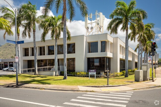
Property Record
850 W Hind Dr, Honolulu, HI 96821

Current Lease Availabilities
NEARBY LISTINGS FOR SALE OR LEASE
Property Detail
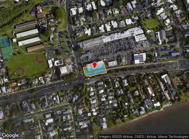
850 W Hind Dr
Urban Honolulu, HI
Aina Haina Prof Bldg
1-3-6-008-051-0000
LOT 1469-A MAP 302 LCAPP 656 29,067 SF
Commercialnec
Honolulu
AE
Hawaii
15003C0388G
1469-
2024
0.67 AC
2025
East Oahu
000302
Hawaii
40,142 SF
DEMOGRAPHICS near 850 W Hind Dr
1 Mile
3 Mile
5 Mile
2024 Total Population
7,700
50,971
167,535
2029 Population
7,436
49,726
165,296
Pop Growth 2024-2029
(3.43%)
(2.44%)
(1.34%)
Average Age
47
46
45
2024 Total Households
2,633
17,445
65,083
HH Growth 2024-2029
(4.25%)
(3.26%)
(1.49%)
Median Household Inc
$169,267
$130,057
$94,081
Avg Household Size
2.80
2.70
2.40
2024 Avg HH Vehicles
2.00
2.00
2.00
Median Home Value
$1,108,786
$1,074,936
$981,699
Median Year Built
1965
1965
1970
Nearby Places
Map Layers
Map Styles
 Street
 Aerial
- Restaurants
- Banks
- Shops
- Fitness
- Groceries
PUBLIC TRANSPORTATION
AIRPORT
Daniel K Inouye International
DRIVE
WALK
Distance
Daniel K Inouye International
23 min
13.0 mi
Freight Ports
Honolulu Harbor, Oahu
DRIVE
WALK
Distance
Honolulu Harbor, Oahu
25 min
12.8 mi
Nearby Properties
Address
Land Use
TOTAL SIZE
Lot Size
Zoning
Address
Land Use
TOTAL SIZE
Lot Size
Zoning
206,214 SF
6.49 AC
Resort
Address
Land Use
TOTAL SIZE
Lot Size
Zoning
825,841 SF
20.25 AC
B-2
Address
Land Use
TOTAL SIZE
Lot Size
Zoning
64,703 SF
4.70 AC
B-1
Address
Land Use
TOTAL SIZE
Lot Size
Zoning
146,113 SF
8.45 AC
B-2
Address
Land Use
TOTAL SIZE
Lot Size
Zoning
39,551 SF
B-1
Address
Land Use
TOTAL SIZE
Lot Size
Zoning
2.84 AC
B-2
Address
Land Use
TOTAL SIZE
Lot Size
Zoning
65,337 SF
5.41 AC
B-1
Address
Land Use
TOTAL SIZE
Lot Size
Zoning
84,153 SF
0.61 AC
B-2
Address
Land Use
TOTAL SIZE
Lot Size
Zoning
36,415 SF
144.72 AC
P-2
Address
Land Use
TOTAL SIZE
Lot Size
Zoning
41,546 SF
0.91 AC
B-2
Address
Land Use
TOTAL SIZE
Lot Size
Zoning
33,461 SF
1.63 AC
B-2
Address
Land Use
TOTAL SIZE
Lot Size
Zoning
58,646 SF
2.27 AC
B-2
Address
Land Use
TOTAL SIZE
Lot Size
Zoning
0.83 AC
B-2
Address
Land Use
TOTAL SIZE
Lot Size
Zoning
89,202 SF
1.07 AC
B-2
Address
Land Use
TOTAL SIZE
Lot Size
Zoning
14,850 SF
1.38 AC
B-2
Address
Land Use
TOTAL SIZE
Lot Size
Zoning
4.05 AC
B-2
Address
Land Use
TOTAL SIZE
Lot Size
Zoning
12,000 SF
2.01 AC
R-10
Address
Land Use
TOTAL SIZE
Lot Size
Zoning
17,614 SF
0.64 AC
B-2
Address
Land Use
TOTAL SIZE
Lot Size
Zoning
102,656 SF
1.15 AC
B-2
Address
Land Use
TOTAL SIZE
Lot Size
Zoning
91,000 SF
1.29 AC
B-2
Address
Land Use
TOTAL SIZE
Lot Size
Zoning
5,838 SF
0.79 AC
R-5
Address
Land Use
TOTAL SIZE
Lot Size
Zoning
3.20 AC
B-2
Address
Land Use
TOTAL SIZE
Lot Size
Zoning
1.18 AC
B-2
Address
Land Use
TOTAL SIZE
Lot Size
Zoning
19,666 SF
0.97 AC
B-2
Address
Land Use
TOTAL SIZE
Lot Size
Zoning
43,438 SF
1.07 AC
B-2
Address
Land Use
TOTAL SIZE
Lot Size
Zoning
30,752 SF
0.90 AC
B-2
Address
Land Use
TOTAL SIZE
Lot Size
Zoning
19,717 SF
0.34 AC
B-2
Address
Land Use
TOTAL SIZE
Lot Size
Zoning
11,366 SF
0.49 AC
R-5
Address
Land Use
TOTAL SIZE
Lot Size
Zoning
47,741 SF
0.69 AC
B-2
Address
Land Use
TOTAL SIZE
Lot Size
Zoning
13,985 SF
0.93 AC
B-2
The World's #1 Commercial Real Estate Marketplace
Connect with us
© 2025 CoStar Group
The information above has been obtained from sources believed reliable. While we do not doubt its accuracy we have not verified it and make no guarantee, warranty or representation about it. It is your responsibility to independently confirm its accuracy and completeness. Any projections, opinions, assumptions, or estimates used are for example only and do not represent the current or future performance of the property. The value of this transaction to you depends on tax and other factors which should be evaluated by your tax, financial, and legal advisors. You and your advisors should conduct a careful, independent investigation of the property to determine to your satisfaction the suitability of the property for your needs.