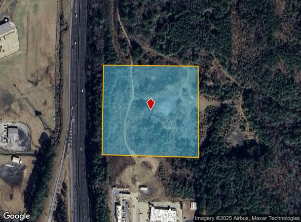
Property Record
850 Westwood Dr, Warrior, AL 35180

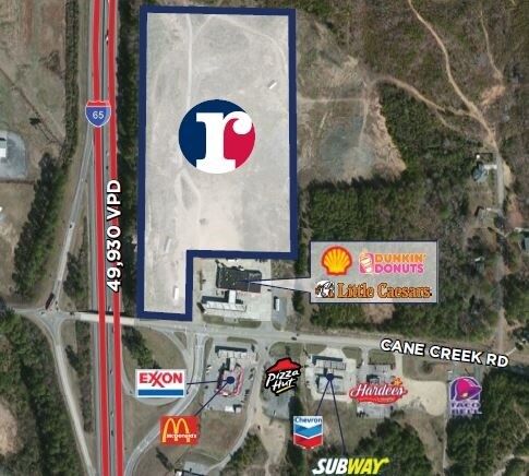

NEARBY LISTINGS FOR SALE OR LEASE
Property Detail
850 Westwood Dr
03-00-14-3-000-001.001
THE S 589.6 FT OF SE 1/4 OF SE 1/4 OF SW 1/4 SEC 14 TP 14 R 3W
Vacantlandnec
Jefferson
X
Alabama
01009C0425F
8.90 AC
2023
Fultondale
2024
Birmingham
0114001030
Birmingham-Hoover, AL
DEMOGRAPHICS near 850 Westwood Dr
1 Mile
3 Mile
5 Mile
2024 Total Population
1,147
5,973
17,540
2029 Population
1,129
5,938
17,370
Pop Growth 2024-2029
(1.57%)
(0.59%)
(0.97%)
Average Age
41
40
40
2024 Total Households
490
2,355
6,620
HH Growth 2024-2029
(1.63%)
(0.68%)
(0.98%)
Median Household Inc
$32,740
$61,637
$73,090
Avg Household Size
2.40
2.50
2.60
2024 Avg HH Vehicles
2.00
2.00
2.00
Median Home Value
$118,110
$169,836
$193,979
Median Year Built
1971
1988
1992
Nearby Places
Map Layers
Map Styles
 Street
 Aerial
- Restaurants
- Banks
- Shops
- Fitness
- Groceries
PUBLIC TRANSPORTATION
AIRPORT
Birmingham-Shuttlesworth International
DRIVE
WALK
Distance
Birmingham-Shuttlesworth International
39 min
32.7 mi
Freight Ports
Port of Mobile
DRIVE
WALK
Distance
Port of Mobile
308 min
282.5 mi
SALE & LEASE HISTORY
LISTING DATE
SALE/LEASE

Sep 24, 2016
For Sale
Jun 25, 2018
For Sale
Nearby Properties
Address
Land Use
TOTAL SIZE
Lot Size
Zoning
Address
Land Use
TOTAL SIZE
Lot Size
Zoning
89,126 SF
80 AC
INST
Address
Land Use
TOTAL SIZE
Lot Size
Zoning
55,467 SF
7.30 AC
GB
Address
Land Use
TOTAL SIZE
Lot Size
Zoning
13,988 SF
1.61 AC
B
Address
Land Use
TOTAL SIZE
Lot Size
Zoning
6,296 SF
2.10 AC
Address
Land Use
TOTAL SIZE
Lot Size
Zoning
27,903 SF
13 AC
Address
Land Use
TOTAL SIZE
Lot Size
Zoning
6,370 SF
4.14 AC
B3
Address
Land Use
TOTAL SIZE
Lot Size
Zoning
6,460 SF
5.20 AC
Address
Land Use
TOTAL SIZE
Lot Size
Zoning
6,863 SF
0.70 AC
C1-A
Address
Land Use
TOTAL SIZE
Lot Size
Zoning
5,100 SF
1 AC
B
Address
Land Use
TOTAL SIZE
Lot Size
Zoning
7,105 SF
1.70 AC
Address
Land Use
TOTAL SIZE
Lot Size
Zoning
6,509 SF
4.09 AC
B
Address
Land Use
TOTAL SIZE
Lot Size
Zoning
10,000 SF
0.64 AC
C1
Address
Land Use
TOTAL SIZE
Lot Size
Zoning
41,296 SF
2.12 AC
B
Address
Land Use
TOTAL SIZE
Lot Size
Zoning
23,306 SF
1.81 AC
B2
Address
Land Use
TOTAL SIZE
Lot Size
Zoning
32,400 SF
3.20 AC
Address
Land Use
TOTAL SIZE
Lot Size
Zoning
1,401 SF
0.90 AC
C1 A
Address
Land Use
TOTAL SIZE
Lot Size
Zoning
6,061 SF
3.35 AC
Address
Land Use
TOTAL SIZE
Lot Size
Zoning
10,125 SF
1.76 AC
GB
Address
Land Use
TOTAL SIZE
Lot Size
Zoning
10,672 SF
1.27 AC
C1
Address
Land Use
TOTAL SIZE
Lot Size
Zoning
3,437 SF
0.84 AC
R1&B
Address
Land Use
TOTAL SIZE
Lot Size
Zoning
10,000 SF
8.20 AC
Address
Land Use
TOTAL SIZE
Lot Size
Zoning
7,225 SF
0.93 AC
B1
Address
Land Use
TOTAL SIZE
Lot Size
Zoning
9,106 SF
0.78 AC
B1
Address
Land Use
TOTAL SIZE
Lot Size
Zoning
5,822 SF
0.71 AC
R3
Address
Land Use
TOTAL SIZE
Lot Size
Zoning
8,200 SF
1.50 AC
Address
Land Use
TOTAL SIZE
Lot Size
Zoning
2,397 SF
1.46 AC
C1-A
Address
Land Use
TOTAL SIZE
Lot Size
Zoning
4.30 AC
B
Address
Land Use
TOTAL SIZE
Lot Size
Zoning
11,111 SF
0.95 AC
R2
Address
Land Use
TOTAL SIZE
Lot Size
Zoning
2,400 SF
1.03 AC
Address
Land Use
TOTAL SIZE
Lot Size
Zoning
11,526 SF
3.67 AC
R1
The World's #1 Commercial Real Estate Marketplace
Connect with us
© 2025 CoStar Group
The information above has been obtained from sources believed reliable. While we do not doubt its accuracy we have not verified it and make no guarantee, warranty or representation about it. It is your responsibility to independently confirm its accuracy and completeness. Any projections, opinions, assumptions, or estimates used are for example only and do not represent the current or future performance of the property. The value of this transaction to you depends on tax and other factors which should be evaluated by your tax, financial, and legal advisors. You and your advisors should conduct a careful, independent investigation of the property to determine to your satisfaction the suitability of the property for your needs.