Property Record
8500 Hedge Lane Ter, Lenexa, KS 66227

Save to a Folder
{{folder.Name}}
{{folder.ListingIds.length}} Properties
{{folder.ListingIds.length}} Property
Create a New Folder
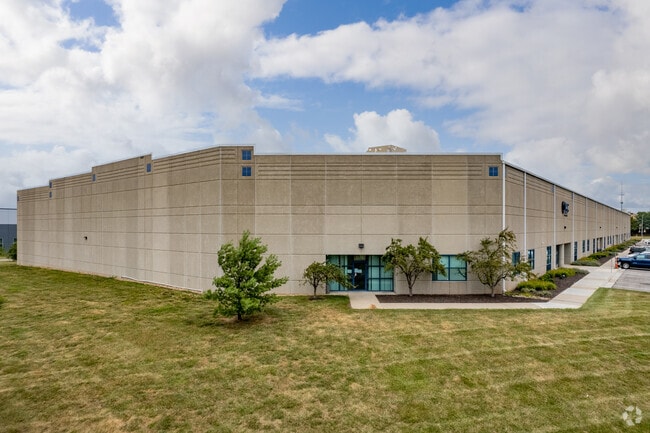
Property Detail
8500 Hedge Lane Ter
Kansas City, MO-KS
PERIMETER PARK FIFTH PLAT BG NW CR LT 10 ELY ALG CUR LF 290.94 SE 89.42 & 42.43 SW 223.64 SLY & SWLY CUR RT 641W 232.19 NE 392.38 201.85 & 241.58 TO POB SHC 486 1C 10A
QP53100000-0010A
JOHNSON
Warehouse
Kansas
PI
10
2025
7.85 AC
2025
Lenexa
052604
Kansas City
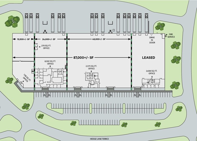
110,360 SF
NEARBY LISTINGS FOR SALE OR LEASE
DEMOGRAPHICS near 8500 Hedge Lane Ter
1 mile
3 mile
5 mile
2025 Total Population
3,417
25,252
78,804
2030 Population
3,624
26,596
82,139
Pop Growth 2025-2030
+ 6.06%
+ 5.32%
+ 4.23%
Average Age
40
41
39
2025 Total Households
1,195
8,848
28,880
HH Growth 2025-2030
+ 6.28%
+ 5.46%
+ 4.34%
Median Household Inc
$143,888
$152,293
$138,873
Avg Household Size
2.80
2.80
2.70
2025 Avg HH Vehicles
2.00
2.00
2.00
Median Home Value
$448,557
$524,457
$463,676
Median Year Built
2008
2006
2004
Nearby Places
Map Layers
Map Styles
 Street
 Aerial
Layers
 Traffic
 Biking
Places
Listings with unknown addresses are not visible on the map
- Restaurants
- Banks
- Shops
- Fitness
- Groceries
PUBLIC TRANSPORTATION
AIRPORT
Kansas City International
Drive
Walk
Distance
Kansas City International
47 min
36.8 mi
SALE & LEASE HISTORY
LISTING DATE
SALE/LEASE

Jun 03, 2021
For Lease
Nearby Properties
Address
Land Use
TOTAL SIZE
Lot Size
Zoning
Address
Land Use
TOTAL SIZE
Lot Size
Zoning
39,668 SF
6.02 AC
Address
Land Use
TOTAL SIZE
Lot Size
Zoning
163,515 SF
70.39 AC
R1
Address
Land Use
TOTAL SIZE
Lot Size
Zoning
106,283 SF
11.79 AC
R1
Address
Land Use
TOTAL SIZE
Lot Size
Zoning
146,926 SF
29.23 AC
R-1
Address
Land Use
TOTAL SIZE
Lot Size
Zoning
68,131 SF
6.01 AC
Address
Land Use
TOTAL SIZE
Lot Size
Zoning
91,639 SF
19.51 AC
R1
Address
Land Use
TOTAL SIZE
Lot Size
Zoning
192,548 SF
20.09 AC
BP
Address
Land Use
TOTAL SIZE
Lot Size
Zoning
69,675 SF
11.85 AC
R1
Address
Land Use
TOTAL SIZE
Lot Size
Zoning
91,640 SF
32.55 AC
R1
Address
Land Use
TOTAL SIZE
Lot Size
Zoning
32,186 SF
2.80 AC
CH
Address
Land Use
TOTAL SIZE
Lot Size
Zoning
138,758 SF
36.62 AC
BP
Address
Land Use
TOTAL SIZE
Lot Size
Zoning
67,008 SF
26.85 AC
AG
Address
Land Use
TOTAL SIZE
Lot Size
Zoning
99,600 SF
7.77 AC
PI
Address
Land Use
TOTAL SIZE
Lot Size
Zoning
75,626 SF
17.48 AC
AG
Address
Land Use
TOTAL SIZE
Lot Size
Zoning
42,261 SF
9.58 AC
R1
Address
Land Use
TOTAL SIZE
Lot Size
Zoning
47.37 AC
CTY A
Address
Land Use
TOTAL SIZE
Lot Size
Zoning
74,420 SF
20.04 AC
AG
Address
Land Use
TOTAL SIZE
Lot Size
Zoning
73,003 SF
15.62 AC
R1
Address
Land Use
TOTAL SIZE
Lot Size
Zoning
30,751 SF
9.73 AC
R1
Address
Land Use
TOTAL SIZE
Lot Size
Zoning
515,928 SF
71.63 AC
BP
Address
Land Use
TOTAL SIZE
Lot Size
Zoning
515,334 SF
58.88 AC
BP
Address
Land Use
TOTAL SIZE
Lot Size
Zoning
30.82 AC
BP
Address
Land Use
TOTAL SIZE
Lot Size
Zoning
24,208 SF
8.13 AC
CPO
Address
Land Use
TOTAL SIZE
Lot Size
Zoning
28,707 SF
11.92 AC
R1
Address
Land Use
TOTAL SIZE
Lot Size
Zoning
483,724 SF
50.52 AC
BP
Address
Land Use
TOTAL SIZE
Lot Size
Zoning
4.93 AC
CTY RUR
Address
Land Use
TOTAL SIZE
Lot Size
Zoning
32,412 SF
19.93 AC
BP
Address
Land Use
TOTAL SIZE
Lot Size
Zoning
87,750 SF
20.57 AC
CTY R-3
Address
Land Use
TOTAL SIZE
Lot Size
Zoning
13,500 SF
10.92 AC
R1
Address
Land Use
TOTAL SIZE
Lot Size
Zoning
24,478 SF
3.10 AC
R1
The World's #1 Commercial Real Estate Marketplace
Connect with us
© 2026 CoStar Group
The information above has been obtained from sources believed reliable. While we do not doubt its accuracy we have not verified it and make no guarantee, warranty or representation about it. It is your responsibility to independently confirm its accuracy and completeness. Any projections, opinions, assumptions, or estimates used are for example only and do not represent the current or future performance of the property. The value of this transaction to you depends on tax and other factors which should be evaluated by your tax, financial, and legal advisors. You and your advisors should conduct a careful, independent investigation of the property to determine to your satisfaction the suitability of the property for your needs.