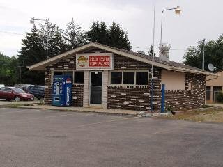
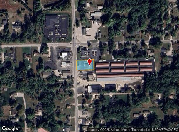
Property Record
8500 Secor Rd, Lambertville, MI 48144
NEARBY LISTINGS FOR SALE OR LEASE
Property Detail
8500 Secor Rd
02-020-095-10
SEC 20 T8S R7E .39 ACRE W 170 FT OF N 100 FT OF W 6 AC OF S 10 AC OF N 15 AC OF N 1/2 OF NW 1/4 OF SW 1/4 OF SEC 20
Restaurantbuilding
Monroe
X
Michigan
26115C0344E
0.39 AC
2024
Monroe County
2025
Detroit
833100
Monroe, MI
750 SF
DEMOGRAPHICS near 8500 Secor Rd
1 Mile
3 Mile
5 Mile
2024 Total Population
3,559
22,475
76,769
2029 Population
3,587
22,624
76,311
Pop Growth 2024-2029
+ 0.79%
+ 0.66%
(0.60%)
Average Age
43
44
42
2024 Total Households
1,353
9,061
32,328
HH Growth 2024-2029
+ 0.74%
+ 0.61%
(0.64%)
Median Household Inc
$86,661
$74,359
$66,469
Avg Household Size
2.60
2.50
2.30
2024 Avg HH Vehicles
2.00
2.00
2.00
Median Home Value
$236,553
$218,911
$172,924
Median Year Built
1975
1975
1969
Nearby Places
Map Layers
Map Styles
 Street
 Aerial
- Restaurants
- Banks
- Shops
- Fitness
- Groceries
PUBLIC TRANSPORTATION
AIRPORT
Eugene F Kranz Toledo Express
DRIVE
WALK
Distance
Eugene F Kranz Toledo Express
42 min
25.3 mi
Freight Ports
Port of Toledo
DRIVE
WALK
Distance
Port of Toledo
33 min
17.0 mi
Nearby Properties
Address
Land Use
TOTAL SIZE
Lot Size
Zoning
Address
Land Use
TOTAL SIZE
Lot Size
Zoning
165,739 SF
17.77 AC
Address
Land Use
TOTAL SIZE
Lot Size
Zoning
61,718 SF
7 AC
Address
Land Use
TOTAL SIZE
Lot Size
Zoning
6.58 AC
Address
Land Use
TOTAL SIZE
Lot Size
Zoning
87,898 SF
9.17 AC
Address
Land Use
TOTAL SIZE
Lot Size
Zoning
64,980 SF
5.80 AC
Address
Land Use
TOTAL SIZE
Lot Size
Zoning
49,875 SF
3.97 AC
Address
Land Use
TOTAL SIZE
Lot Size
Zoning
18,970 SF
3.72 AC
Address
Land Use
TOTAL SIZE
Lot Size
Zoning
53,933 SF
5.26 AC
Address
Land Use
TOTAL SIZE
Lot Size
Zoning
5.31 AC
Address
Land Use
TOTAL SIZE
Lot Size
Zoning
30,108 SF
4.43 AC
Address
Land Use
TOTAL SIZE
Lot Size
Zoning
34,634 SF
37.38 AC
B2
Address
Land Use
TOTAL SIZE
Lot Size
Zoning
6,420 SF
2.12 AC
Address
Land Use
TOTAL SIZE
Lot Size
Zoning
12,400 SF
3.54 AC
Address
Land Use
TOTAL SIZE
Lot Size
Zoning
5,848 SF
1.09 AC
Address
Land Use
TOTAL SIZE
Lot Size
Zoning
6,400 SF
12 AC
Address
Land Use
TOTAL SIZE
Lot Size
Zoning
87,299 SF
6.25 AC
Address
Land Use
TOTAL SIZE
Lot Size
Zoning
7,606 SF
1.35 AC
Address
Land Use
TOTAL SIZE
Lot Size
Zoning
1.61 AC
Address
Land Use
TOTAL SIZE
Lot Size
Zoning
5,364 SF
0.46 AC
PUD
Address
Land Use
TOTAL SIZE
Lot Size
Zoning
10,200 SF
1.15 AC
Address
Land Use
TOTAL SIZE
Lot Size
Zoning
5,140 SF
1.45 AC
Address
Land Use
TOTAL SIZE
Lot Size
Zoning
19,605 SF
9.23 AC
Address
Land Use
TOTAL SIZE
Lot Size
Zoning
3,414 SF
1.74 AC
Address
Land Use
TOTAL SIZE
Lot Size
Zoning
9,570 SF
0.98 AC
Address
Land Use
TOTAL SIZE
Lot Size
Zoning
5,194 SF
1.30 AC
Address
Land Use
TOTAL SIZE
Lot Size
Zoning
3,080 SF
49.32 AC
Address
Land Use
TOTAL SIZE
Lot Size
Zoning
78,682 SF
63.05 AC
Address
Land Use
TOTAL SIZE
Lot Size
Zoning
41,500 SF
2.76 AC
Address
Land Use
TOTAL SIZE
Lot Size
Zoning
10,897 SF
1.40 AC
Address
Land Use
TOTAL SIZE
Lot Size
Zoning
14,132 SF
1.25 AC
The World's #1 Commercial Real Estate Marketplace
Connect with us
© 2025 CoStar Group
The information above has been obtained from sources believed reliable. While we do not doubt its accuracy we have not verified it and make no guarantee, warranty or representation about it. It is your responsibility to independently confirm its accuracy and completeness. Any projections, opinions, assumptions, or estimates used are for example only and do not represent the current or future performance of the property. The value of this transaction to you depends on tax and other factors which should be evaluated by your tax, financial, and legal advisors. You and your advisors should conduct a careful, independent investigation of the property to determine to your satisfaction the suitability of the property for your needs.