Property Record
8500 Surf Dr, Panama City, FL 32408
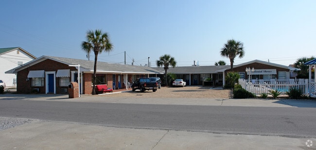

Property Detail
8500 Surf Dr
30350-000-000
COLONIAL SHORES CONDO 6 4S 15W -167.8- MAP 58B3 ORB 931 P 555 ENDING RE# 30472-418-000
Multifamilydwelling
Bay
BC23
Florida
VE and V1-30 Coastal areas with a 1% or greater chance of flooding and an additional hazard associated with storm waves. These areas have a 26% chance of flooding over the life of a 30-year mortgage.
0.14 AC
0
Panama City
2025
Other Market Areas
002605
Panama City-Panama City Beach, FL
3,168 SF
NEARBY LISTINGS FOR SALE OR LEASE
-
-
View all Panama City listings for sale on LoopNet.com
DEMOGRAPHICS near 8500 Surf Dr
1 mile
3 mile
5 mile
2025 Total Population
6,920
38,441
51,445
2030 Population
8,144
45,301
60,028
Pop Growth 2025-2030
+ 17.69%
+ 17.85%
+ 16.68%
Average Age
45
44
44
2025 Total Households
3,158
17,616
22,978
HH Growth 2025-2030
+ 18.75%
+ 18.54%
+ 17.38%
Median Household Inc
$66,203
$71,969
$72,934
Avg Household Size
2.20
2.10
2.20
2025 Avg HH Vehicles
2.00
2.00
2.00
Median Home Value
$378,129
$382,226
$390,196
Median Year Built
1989
1999
1998
Nearby Places
Map Layers
Map Styles
 Street
 Aerial
Layers
 Traffic
 Biking
Places
Listings with unknown addresses are not visible on the map
- Restaurants
- Banks
- Shops
- Fitness
- Groceries
PUBLIC TRANSPORTATION
AIRPORT
Northwest Florida Beaches International
Drive
Walk
Distance
Northwest Florida Beaches International
33 min
20.0 mi
Freight Ports
Port of Panama City
Drive
Walk
Distance
Port of Panama City
10 min
5.0 mi
Nearby Properties
Address
Land Use
TOTAL SIZE
Lot Size
Zoning
Address
Land Use
TOTAL SIZE
Lot Size
Zoning
96 AC
BC14
Address
Land Use
TOTAL SIZE
Lot Size
Zoning
68 AC
BC14
Address
Land Use
TOTAL SIZE
Lot Size
Zoning
176.88 AC
BC14
Address
Land Use
TOTAL SIZE
Lot Size
Zoning
341,086 SF
18.98 AC
PCB21
Address
Land Use
TOTAL SIZE
Lot Size
Zoning
350,105 SF
16.70 AC
PCB24
Address
Land Use
TOTAL SIZE
Lot Size
Zoning
335,150 SF
17.17 AC
BC05
Address
Land Use
TOTAL SIZE
Lot Size
Zoning
354,137 SF
20.13 AC
PCB22
Address
Land Use
TOTAL SIZE
Lot Size
Zoning
285,798 SF
16.50 AC
BC19
Address
Land Use
TOTAL SIZE
Lot Size
Zoning
370,951 SF
19.87 AC
PCB22
Address
Land Use
TOTAL SIZE
Lot Size
Zoning
328,049 SF
33.54 AC
PCB17
Address
Land Use
TOTAL SIZE
Lot Size
Zoning
40,690 SF
24.86 AC
BC19
Address
Land Use
TOTAL SIZE
Lot Size
Zoning
254,904 SF
20.60 AC
BC05
Address
Land Use
TOTAL SIZE
Lot Size
Zoning
186,975 SF
4.12 AC
PCB21
Address
Land Use
TOTAL SIZE
Lot Size
Zoning
210,652 SF
19.47 AC
BC19
Address
Land Use
TOTAL SIZE
Lot Size
Zoning
132,433 SF
6.43 AC
PCB21
Address
Land Use
TOTAL SIZE
Lot Size
Zoning
206,450 SF
12.52 AC
BC05
Address
Land Use
TOTAL SIZE
Lot Size
Zoning
56,045 SF
2.82 AC
BC05
Address
Land Use
TOTAL SIZE
Lot Size
Zoning
176,759 SF
20 AC
PCB24
Address
Land Use
TOTAL SIZE
Lot Size
Zoning
43,287 SF
7.73 AC
BC04
Address
Land Use
TOTAL SIZE
Lot Size
Zoning
166,871 SF
39.70 AC
PCB22
Address
Land Use
TOTAL SIZE
Lot Size
Zoning
97,474 SF
11.55 AC
PCB21
Address
Land Use
TOTAL SIZE
Lot Size
Zoning
22,462 SF
1.99 AC
BC05
Address
Land Use
TOTAL SIZE
Lot Size
Zoning
14,183 SF
11.99 AC
PCB22
Address
Land Use
TOTAL SIZE
Lot Size
Zoning
216,844 SF
25.60 AC
PCB22
Address
Land Use
TOTAL SIZE
Lot Size
Zoning
145,935 SF
45.63 AC
Address
Land Use
TOTAL SIZE
Lot Size
Zoning
112,780 SF
20.85 AC
BC14
Address
Land Use
TOTAL SIZE
Lot Size
Zoning
143,993 SF
7.27 AC
BC05
Address
Land Use
TOTAL SIZE
Lot Size
Zoning
50,377 SF
1.88 AC
BC05
Address
Land Use
TOTAL SIZE
Lot Size
Zoning
50,354 SF
2.44 AC
BC05
Address
Land Use
TOTAL SIZE
Lot Size
Zoning
55 AC
BC14
The World's #1 Commercial Real Estate Marketplace
Connect with us
© 2026 CoStar Group
The information above has been obtained from sources believed reliable. While we do not doubt its accuracy we have not verified it and make no guarantee, warranty or representation about it. It is your responsibility to independently confirm its accuracy and completeness. Any projections, opinions, assumptions, or estimates used are for example only and do not represent the current or future performance of the property. The value of this transaction to you depends on tax and other factors which should be evaluated by your tax, financial, and legal advisors. You and your advisors should conduct a careful, independent investigation of the property to determine to your satisfaction the suitability of the property for your needs.