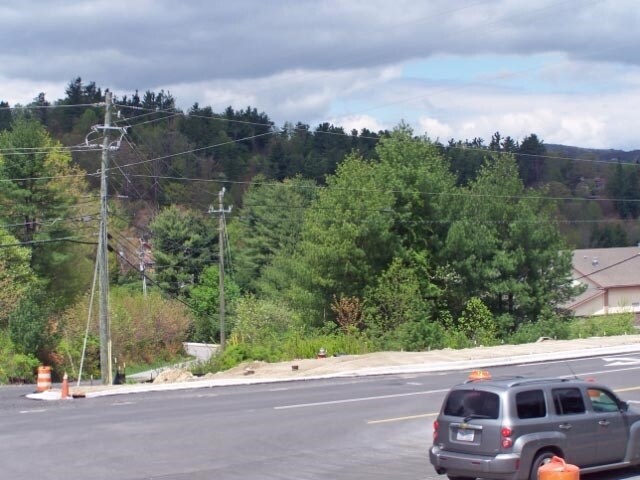
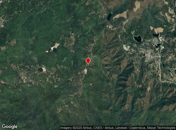
Property Record
330 Yonahlossee Trl, Blowing Rock, NC 28605

NEARBY LISTINGS FOR SALE OR LEASE
-
-
View all Blowing Rock listings for sale on LoopNet.com
Property Detail
330 Yonahlossee Trl
2817-14-0664-000
Watauga
Commercialacreage
North Carolina
X
0.64 AC
3710281700J
Hickory/Morganton
2024
Other Market Areas
2025
Boone, NC
920800
DEMOGRAPHICS near 330 Yonahlossee Trl
1 Mile
3 Mile
5 Mile
2024 Total Population
1,992
4,091
9,154
2029 Population
2,167
4,413
9,618
Pop Growth 2024-2029
+ 8.79%
+ 7.87%
+ 5.07%
Average Age
49
49
45
2024 Total Households
955
1,953
4,244
HH Growth 2024-2029
+ 9.21%
+ 8.29%
+ 5.40%
Median Household Inc
$70,449
$67,852
$60,760
Avg Household Size
2.10
2.10
2.10
2024 Avg HH Vehicles
2.00
2.00
2.00
Median Home Value
$401,250
$387,455
$373,791
Median Year Built
1989
1988
1988
Nearby Places
- Restaurants
- Banks
- Shops
- Fitness
- Groceries
SALE & LEASE HISTORY
LISTING DATE
SALE/LEASE

Sep 24, 2016
For Sale
Aug 29, 2017
For Sale
Nearby Properties
Address
Land Use
TOTAL SIZE
Lot Size
Zoning
Address
Land Use
TOTAL SIZE
Lot Size
Zoning
38,694 SF
4.51 AC
BRGB
Address
Land Use
TOTAL SIZE
Lot Size
Zoning
57,681 SF
17.09 AC
BRGB
Address
Land Use
TOTAL SIZE
Lot Size
Zoning
19,940 SF
17.48 AC
Address
Land Use
TOTAL SIZE
Lot Size
Zoning
21,019 SF
3.72 AC
BRCB
Address
Land Use
TOTAL SIZE
Lot Size
Zoning
25,645 SF
2.97 AC
BRCB
Address
Land Use
TOTAL SIZE
Lot Size
Zoning
19,142 SF
0.91 AC
Address
Land Use
TOTAL SIZE
Lot Size
Zoning
43,504 SF
4.27 AC
BRGB
Address
Land Use
TOTAL SIZE
Lot Size
Zoning
3,771 SF
3.16 AC
BRCB
Address
Land Use
TOTAL SIZE
Lot Size
Zoning
6,482 SF
9.12 AC
Address
Land Use
TOTAL SIZE
Lot Size
Zoning
19,142 SF
0.27 AC
BRCB
Address
Land Use
TOTAL SIZE
Lot Size
Zoning
92,696 SF
4.59 AC
BRGB
Address
Land Use
TOTAL SIZE
Lot Size
Zoning
6,102 SF
4.87 AC
Address
Land Use
TOTAL SIZE
Lot Size
Zoning
11,791 SF
1 AC
BRCB
Address
Land Use
TOTAL SIZE
Lot Size
Zoning
26,928 SF
0.94 AC
BRCB
Address
Land Use
TOTAL SIZE
Lot Size
Zoning
20,645 SF
5.50 AC
BRR15
Address
Land Use
TOTAL SIZE
Lot Size
Zoning
21,474 SF
1.20 AC
BRGB
Address
Land Use
TOTAL SIZE
Lot Size
Zoning
18,471 SF
0.33 AC
BRMZ
Address
Land Use
TOTAL SIZE
Lot Size
Zoning
8,140 SF
123.33 AC
BRR15
Address
Land Use
TOTAL SIZE
Lot Size
Zoning
868 SF
4.60 AC
Address
Land Use
TOTAL SIZE
Lot Size
Zoning
9,333 SF
0.68 AC
BRR6
Address
Land Use
TOTAL SIZE
Lot Size
Zoning
19,476 SF
1.58 AC
BRGB
Address
Land Use
TOTAL SIZE
Lot Size
Zoning
64.28 AC
Address
Land Use
TOTAL SIZE
Lot Size
Zoning
8.76 AC
BRR6
Address
Land Use
TOTAL SIZE
Lot Size
Zoning
7.76 AC
BRR15
Address
Land Use
TOTAL SIZE
Lot Size
Zoning
7,310 SF
0.93 AC
BRCB
Address
Land Use
TOTAL SIZE
Lot Size
Zoning
1,725 SF
1.96 AC
BRGB
Address
Land Use
TOTAL SIZE
Lot Size
Zoning
7,668 SF
0.51 AC
BRCB
Address
Land Use
TOTAL SIZE
Lot Size
Zoning
4,864 SF
0.26 AC
BRCB
Address
Land Use
TOTAL SIZE
Lot Size
Zoning
1,566 SF
1.22 AC
BRMZ
The World's #1 Commercial Real Estate Marketplace
Connect with us
© 2025 CoStar Group
The information above has been obtained from sources believed reliable. While we do not doubt its accuracy we have not verified it and make no guarantee, warranty or representation about it. It is your responsibility to independently confirm its accuracy and completeness. Any projections, opinions, assumptions, or estimates used are for example only and do not represent the current or future performance of the property. The value of this transaction to you depends on tax and other factors which should be evaluated by your tax, financial, and legal advisors. You and your advisors should conduct a careful, independent investigation of the property to determine to your satisfaction the suitability of the property for your needs.