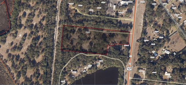
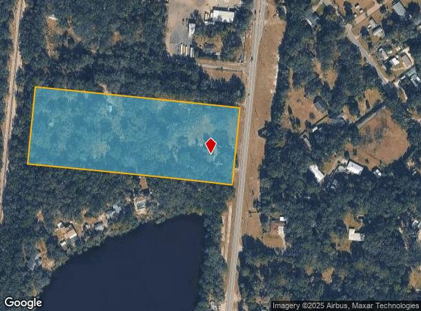
Property Record
850343 Us Highway 17, Yulee, FL 32097

This Property Is For Sale
NEARBY LISTINGS FOR SALE OR LEASE
Property Detail
850343 Us Highway 17
Jacksonville, FL
John Lowe Mill Grant
42-2N-27-0000-0100-0000
Nassau
Sfr
Florida
X
8.69 AC
12031C0055J
Nassau County
1,485 SF
Jacksonville (Florida)
DEMOGRAPHICS near 850343 Us Highway 17
1 Mile
3 Mile
5 Mile
2024 Total Population
1,951
13,157
36,651
2029 Population
2,346
15,888
43,767
Pop Growth 2024-2029
+ 20.25%
+ 20.76%
+ 19.42%
Average Age
40
41
41
2024 Total Households
714
4,912
13,576
HH Growth 2024-2029
+ 21.43%
+ 21.97%
+ 20.63%
Median Household Inc
$66,964
$74,279
$81,289
Avg Household Size
2.60
2.60
2.60
2024 Avg HH Vehicles
2.00
2.00
2.00
Median Home Value
$210,092
$264,246
$279,366
Median Year Built
1998
2004
2007
Nearby Places
- Restaurants
- Banks
- Shops
- Fitness
- Groceries
PUBLIC TRANSPORTATION
AIRPORT
Jacksonville International
DRIVE
WALK
Distance
Jacksonville International
19 min
11.1 mi
Freight Ports
Jacksonville Port
DRIVE
WALK
Distance
Jacksonville Port
29 min
21.4 mi
Nearby Properties
Address
Land Use
TOTAL SIZE
Lot Size
Zoning
Address
Land Use
TOTAL SIZE
Lot Size
Zoning
249,913 SF
160.04 AC
OR
Address
Land Use
TOTAL SIZE
Lot Size
Zoning
297,748 SF
92.23 AC
OR
Address
Land Use
TOTAL SIZE
Lot Size
Zoning
91,196 SF
86.52 AC
OR
Address
Land Use
TOTAL SIZE
Lot Size
Zoning
112,634 SF
16 AC
GPU
Address
Land Use
TOTAL SIZE
Lot Size
Zoning
83,799 SF
13.18 AC
PD - ENCPA
Address
Land Use
TOTAL SIZE
Lot Size
Zoning
42,189 SF
7.69 AC
PD - ENCPA
Address
Land Use
TOTAL SIZE
Lot Size
Zoning
13,472 SF
Address
Land Use
TOTAL SIZE
Lot Size
Zoning
81,960 SF
2.90 AC
PD - ENCPA
Address
Land Use
TOTAL SIZE
Lot Size
Zoning
59,703 SF
12.06 AC
GPU
Address
Land Use
TOTAL SIZE
Lot Size
Zoning
12,594 SF
Address
Land Use
TOTAL SIZE
Lot Size
Zoning
25,920 SF
14.72 AC
GPU
Address
Land Use
TOTAL SIZE
Lot Size
Zoning
89.52 AC
PD - ENCPA
Address
Land Use
TOTAL SIZE
Lot Size
Zoning
83.12 AC
PD - ENCPA
Address
Land Use
TOTAL SIZE
Lot Size
Zoning
18,750 SF
4.58 AC
CI
Address
Land Use
TOTAL SIZE
Lot Size
Zoning
6,285 SF
Address
Land Use
TOTAL SIZE
Lot Size
Zoning
25,635 SF
4.24 AC
CI
Address
Land Use
TOTAL SIZE
Lot Size
Zoning
19,000 SF
21.27 AC
PUD
Address
Land Use
TOTAL SIZE
Lot Size
Zoning
11,598 SF
1.03 AC
PD - ENCPA
Address
Land Use
TOTAL SIZE
Lot Size
Zoning
26,652 SF
3.67 AC
CG
Address
Land Use
TOTAL SIZE
Lot Size
Zoning
10.44 AC
Address
Land Use
TOTAL SIZE
Lot Size
Zoning
9,456 SF
20.63 AC
GPU
Address
Land Use
TOTAL SIZE
Lot Size
Zoning
13,997 SF
5.02 AC
OR
Address
Land Use
TOTAL SIZE
Lot Size
Zoning
1,576 SF
9.36 AC
CG
Address
Land Use
TOTAL SIZE
Lot Size
Zoning
26,450 SF
6.60 AC
RSF-2
Address
Land Use
TOTAL SIZE
Lot Size
Zoning
8,857 SF
1.18 AC
PD - ENCPA
Address
Land Use
TOTAL SIZE
Lot Size
Zoning
9.93 AC
PD - ENCPA
Address
Land Use
TOTAL SIZE
Lot Size
Zoning
15,635 SF
3.03 AC
RSF-2
Address
Land Use
TOTAL SIZE
Lot Size
Zoning
17,100 SF
2.33 AC
CG
Address
Land Use
TOTAL SIZE
Lot Size
Zoning
15,635 SF
3 AC
OR
Address
Land Use
TOTAL SIZE
Lot Size
Zoning
45.19 AC
PD - ENCPA
The World's #1 Commercial Real Estate Marketplace
Connect with us
© 2025 CoStar Group
The information above has been obtained from sources believed reliable. While we do not doubt its accuracy we have not verified it and make no guarantee, warranty or representation about it. It is your responsibility to independently confirm its accuracy and completeness. Any projections, opinions, assumptions, or estimates used are for example only and do not represent the current or future performance of the property. The value of this transaction to you depends on tax and other factors which should be evaluated by your tax, financial, and legal advisors. You and your advisors should conduct a careful, independent investigation of the property to determine to your satisfaction the suitability of the property for your needs.