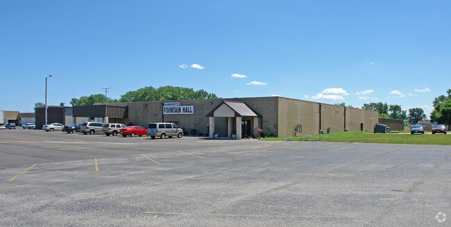
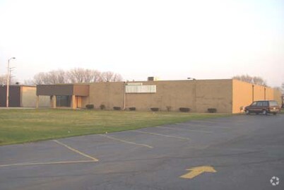
Property Record
8505 Durand Ave, Sturtevant, WI 53177

Save to a Folder
{{folder.Name}}
{{folder.ListingIds.length}} Properties
{{folder.ListingIds.length}} Property
Create a New Folder
Property Detail
8505 Durand Ave
181-032227002000
PT NE1/4 NW1/4 COM 350 E OF NW COR S208 E100 N208 W 100 TO POB EXC V1068P496 & PT NW1/4 COM N1/4 COR W870 S208 W50 TO POB W16
Commercialnec
Racine
003
Wisconsin
B and X Area of moderate flood hazard, usually the area between the limits of the 100-year and 500-year floods.
1.90 AC
2025
Racine East
2025
Milwaukee/Madison
001702
Racine-Mount Pleasant, WI
NEARBY LISTINGS FOR SALE OR LEASE
DEMOGRAPHICS near 8505 Durand Ave
1 mile
3 mile
5 mile
2025 Total Population
5,736
28,177
89,448
2030 Population
5,790
28,547
90,022
Pop Growth 2025-2030
+ 0.94%
+ 1.31%
+ 0.64%
Average Age
40
43
41
2025 Total Households
1,924
11,390
36,003
HH Growth 2025-2030
+ 1.04%
+ 1.32%
+ 0.61%
Median Household Inc
$91,681
$74,693
$73,120
Avg Household Size
2.50
2.20
2.30
2025 Avg HH Vehicles
2.00
2.00
2.00
Median Home Value
$254,709
$246,132
$225,788
Median Year Built
1975
1978
1969
Nearby Places
Map Layers
Map Styles
 Street
 Aerial
Layers
 Traffic
 Biking
Places
Listings with unknown addresses are not visible on the map
- Restaurants
- Banks
- Shops
- Fitness
- Groceries
PUBLIC TRANSPORTATION
COMMUTER RAIL
Drive
Walk
Distance
8 min
3.1 mi
AIRPORT
General Mitchell International
Drive
Walk
Distance
General Mitchell International
31 min
22.8 mi
Freight Ports
Port Milwaukee
Drive
Walk
Distance
Port Milwaukee
36 min
26.6 mi
Nearby Properties
Address
Land Use
TOTAL SIZE
Lot Size
Zoning
Address
Land Use
TOTAL SIZE
Lot Size
Zoning
318.64 AC
Address
Land Use
TOTAL SIZE
Lot Size
Zoning
241.29 AC
Address
Land Use
TOTAL SIZE
Lot Size
Zoning
22.34 AC
Address
Land Use
TOTAL SIZE
Lot Size
Zoning
9.31 AC
Address
Land Use
TOTAL SIZE
Lot Size
Zoning
Address
Land Use
TOTAL SIZE
Lot Size
Zoning
32.55 AC
Address
Land Use
TOTAL SIZE
Lot Size
Zoning
23.10 AC
Address
Land Use
TOTAL SIZE
Lot Size
Zoning
47.01 AC
M-1
Address
Land Use
TOTAL SIZE
Lot Size
Zoning
9.40 AC
B-3
Address
Land Use
TOTAL SIZE
Lot Size
Zoning
37.55 AC
Address
Land Use
TOTAL SIZE
Lot Size
Zoning
26.79 AC
Address
Land Use
TOTAL SIZE
Lot Size
Zoning
23.21 AC
Address
Land Use
TOTAL SIZE
Lot Size
Zoning
57.80 AC
M1
Address
Land Use
TOTAL SIZE
Lot Size
Zoning
20.61 AC
Address
Land Use
TOTAL SIZE
Lot Size
Zoning
30.45 AC
002
Address
Land Use
TOTAL SIZE
Lot Size
Zoning
Address
Land Use
TOTAL SIZE
Lot Size
Zoning
Address
Land Use
TOTAL SIZE
Lot Size
Zoning
Address
Land Use
TOTAL SIZE
Lot Size
Zoning
19.33 AC
002
Address
Land Use
TOTAL SIZE
Lot Size
Zoning
18.33 AC
Address
Land Use
TOTAL SIZE
Lot Size
Zoning
32.99 AC
002
Address
Land Use
TOTAL SIZE
Lot Size
Zoning
Address
Land Use
TOTAL SIZE
Lot Size
Zoning
Address
Land Use
TOTAL SIZE
Lot Size
Zoning
Address
Land Use
TOTAL SIZE
Lot Size
Zoning
5.74 AC
Address
Land Use
TOTAL SIZE
Lot Size
Zoning
16.91 AC
Address
Land Use
TOTAL SIZE
Lot Size
Zoning
22.98 AC
M-1
Address
Land Use
TOTAL SIZE
Lot Size
Zoning
16.97 AC
Address
Land Use
TOTAL SIZE
Lot Size
Zoning
19.77 AC
B-3
Address
Land Use
TOTAL SIZE
Lot Size
Zoning
71.23 AC
The World's #1 Commercial Real Estate Marketplace
Connect with us
© 2026 CoStar Group
The information above has been obtained from sources believed reliable. While we do not doubt its accuracy we have not verified it and make no guarantee, warranty or representation about it. It is your responsibility to independently confirm its accuracy and completeness. Any projections, opinions, assumptions, or estimates used are for example only and do not represent the current or future performance of the property. The value of this transaction to you depends on tax and other factors which should be evaluated by your tax, financial, and legal advisors. You and your advisors should conduct a careful, independent investigation of the property to determine to your satisfaction the suitability of the property for your needs.