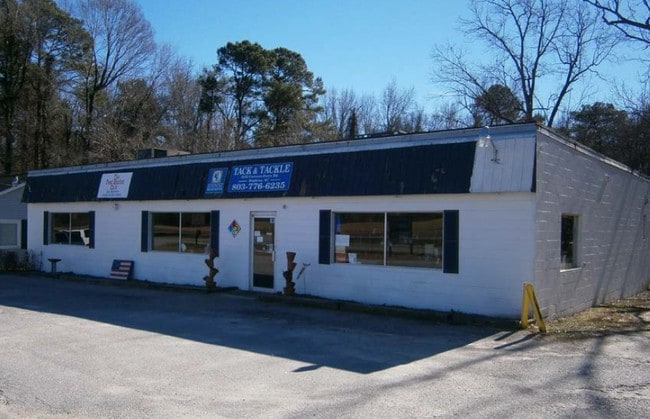
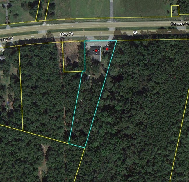
Property Record
8505 Garners Ferry Rd, Hopkins, SC 29061
NEARBY LISTINGS FOR SALE OR LEASE
-
-
View all Hopkins listings for sale on LoopNet.com
Property Detail
8505 Garners Ferry Rd
21800-05-07
Garners Ferry
Commercialnec
150X200X140X200 #SU #PR 1-177 51-3987
A
Richland
45079C0384L
South Carolina
2025
2.45 AC
2024
Southeast Columbia
011901
Columbia
1,164 SF
Columbia, SC
DEMOGRAPHICS near 8505 Garners Ferry Rd
1 Mile
3 Mile
5 Mile
2024 Total Population
604
22,044
45,826
2029 Population
606
22,344
46,601
Pop Growth 2024-2029
+ 0.33%
+ 1.36%
+ 1.69%
Average Age
37
39
39
2024 Total Households
228
9,048
18,058
HH Growth 2024-2029
+ 0.44%
+ 1.40%
+ 1.70%
Median Household Inc
$67,826
$54,563
$57,653
Avg Household Size
2.60
2.40
2.40
2024 Avg HH Vehicles
2.00
2.00
2.00
Median Home Value
$154,424
$153,828
$171,598
Median Year Built
2000
1986
1987
Nearby Places
Map Layers
Map Styles
 Street
 Aerial
- Restaurants
- Banks
- Shops
- Fitness
- Groceries
PUBLIC TRANSPORTATION
AIRPORT
Columbia Metro
DRIVE
WALK
Distance
Columbia Metro
23 min
17.4 mi
Freight Ports
Georgia Ports - Savannah
DRIVE
WALK
Distance
Georgia Ports - Savannah
1 min
126.6 mi
Nearby Properties
Address
Land Use
TOTAL SIZE
Lot Size
Zoning
Address
Land Use
TOTAL SIZE
Lot Size
Zoning
460,078 SF
42.80 AC
M-1
Address
Land Use
TOTAL SIZE
Lot Size
Zoning
294,105 SF
19 AC
RG-2
Address
Land Use
TOTAL SIZE
Lot Size
Zoning
281,304 SF
22.86 AC
RG-2
Address
Land Use
TOTAL SIZE
Lot Size
Zoning
199,263 SF
18.29 AC
C-3
Address
Land Use
TOTAL SIZE
Lot Size
Zoning
56.15 AC
PDD
Address
Land Use
TOTAL SIZE
Lot Size
Zoning
16,140 SF
1.84 AC
PD
Address
Land Use
TOTAL SIZE
Lot Size
Zoning
255,848 SF
19.98 AC
RM-HD
Address
Land Use
TOTAL SIZE
Lot Size
Zoning
125,976 SF
28.95 AC
M-1
Address
Land Use
TOTAL SIZE
Lot Size
Zoning
102.68 AC
M-1
Address
Land Use
TOTAL SIZE
Lot Size
Zoning
60,772 SF
9.30 AC
GC
Address
Land Use
TOTAL SIZE
Lot Size
Zoning
51,516 SF
9.12 AC
GC
Address
Land Use
TOTAL SIZE
Lot Size
Zoning
91.51 AC
M-1
Address
Land Use
TOTAL SIZE
Lot Size
Zoning
92,918 SF
10.39 AC
M-1
Address
Land Use
TOTAL SIZE
Lot Size
Zoning
30,162 SF
3.46 AC
RS-MD
Address
Land Use
TOTAL SIZE
Lot Size
Zoning
114,660 SF
11.02 AC
RM-HD
Address
Land Use
TOTAL SIZE
Lot Size
Zoning
91,726 SF
9.54 AC
RM-HD
Address
Land Use
TOTAL SIZE
Lot Size
Zoning
58,000 SF
5.73 AC
C-3
Address
Land Use
TOTAL SIZE
Lot Size
Zoning
150.94 AC
RU
Address
Land Use
TOTAL SIZE
Lot Size
Zoning
13,888 SF
2 AC
PD
Address
Land Use
TOTAL SIZE
Lot Size
Zoning
84,212 SF
6.88 AC
RG-1A
Address
Land Use
TOTAL SIZE
Lot Size
Zoning
83,156 SF
4.74 AC
RG-2
Address
Land Use
TOTAL SIZE
Lot Size
Zoning
15,638 SF
1.87 AC
GC
Address
Land Use
TOTAL SIZE
Lot Size
Zoning
61,682 SF
4.92 AC
C-3
Address
Land Use
TOTAL SIZE
Lot Size
Zoning
19,465 SF
4.41 AC
RU
Address
Land Use
TOTAL SIZE
Lot Size
Zoning
1,399.70 AC
RU
Address
Land Use
TOTAL SIZE
Lot Size
Zoning
25,184 SF
31 AC
M-1
Address
Land Use
TOTAL SIZE
Lot Size
Zoning
4,966 SF
2.18 AC
LI
Address
Land Use
TOTAL SIZE
Lot Size
Zoning
7,642 SF
2.42 AC
GC
Address
Land Use
TOTAL SIZE
Lot Size
Zoning
6,867 SF
1 AC
GC
Address
Land Use
TOTAL SIZE
Lot Size
Zoning
16,302 SF
1.99 AC
GC
The World's #1 Commercial Real Estate Marketplace
Connect with us
© 2026 CoStar Group
The information above has been obtained from sources believed reliable. While we do not doubt its accuracy we have not verified it and make no guarantee, warranty or representation about it. It is your responsibility to independently confirm its accuracy and completeness. Any projections, opinions, assumptions, or estimates used are for example only and do not represent the current or future performance of the property. The value of this transaction to you depends on tax and other factors which should be evaluated by your tax, financial, and legal advisors. You and your advisors should conduct a careful, independent investigation of the property to determine to your satisfaction the suitability of the property for your needs.