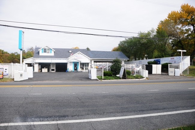
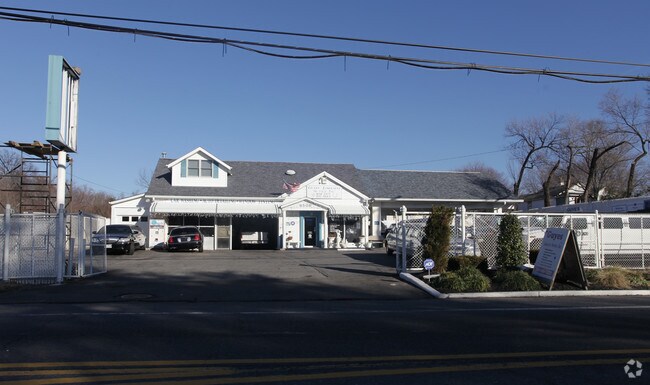
Property Record
8505 Riggs Rd, Hyattsville, MD 20783

NEARBY LISTINGS FOR SALE OR LEASE
Property Detail
8505 Riggs Rd
17-1963586
LOT 100.18X175 FT
Autorepair
Prince George's
X
Maryland
24033C0126E
100
2024
0.40 AC
2025
College Park
805904
Washington, DC
1,680 SF
Washington-Arlington-Alexandria, DC-VA-MD-WV
DEMOGRAPHICS near 8505 Riggs Rd
1 Mile
3 Mile
5 Mile
2024 Total Population
33,389
203,912
514,183
2029 Population
32,469
199,086
496,235
Pop Growth 2024-2029
(2.76%)
(2.37%)
(3.49%)
Average Age
34
36
38
2024 Total Households
9,239
66,436
181,537
HH Growth 2024-2029
(2.87%)
(2.59%)
(3.85%)
Median Household Inc
$66,702
$77,211
$85,588
Avg Household Size
3.40
2.80
2.70
2024 Avg HH Vehicles
2.00
2.00
1.00
Median Home Value
$320,055
$472,745
$488,608
Median Year Built
1964
1961
1961
Nearby Places
Map Layers
Map Styles
 Street
 Aerial
- Restaurants
- Banks
- Shops
- Fitness
- Groceries
PUBLIC TRANSPORTATION
COMMUTER RAIL
College Park Marc Nb (CAMDEN - WASHINGTON - Maryland Transit Administration)
DRIVE
WALK
Distance
College Park Marc Nb (CAMDEN - WASHINGTON - Maryland Transit Administration)
10 min
2.9 mi
College Park Marc Sb (CAMDEN - WASHINGTON - Maryland Transit Administration)
DRIVE
WALK
Distance
College Park Marc Sb (CAMDEN - WASHINGTON - Maryland Transit Administration)
10 min
3.0 mi
AIRPORT
Ronald Reagan Washington Ntl
DRIVE
WALK
Distance
Ronald Reagan Washington Ntl
24 min
13.3 mi
Baltimore/Washington International Thurgood Marshall
DRIVE
WALK
Distance
Baltimore/Washington International Thurgood Marshall
38 min
27.9 mi
Washington Dulles International
DRIVE
WALK
Distance
Washington Dulles International
53 min
34.0 mi
Freight Ports
Port of Baltimore
DRIVE
WALK
Distance
Port of Baltimore
42 min
30.8 mi
SALE & LEASE HISTORY
LISTING DATE
SALE/LEASE

Sep 25, 2016
For Lease
Nearby Properties
Address
Land Use
TOTAL SIZE
Lot Size
Zoning
Address
Land Use
TOTAL SIZE
Lot Size
Zoning
2,043 SF
1,011.13 AC
RR
Address
Land Use
TOTAL SIZE
Lot Size
Zoning
13.01 AC
RR
Address
Land Use
TOTAL SIZE
Lot Size
Zoning
2,985,682 SF
4.33 AC
RSF65
Address
Land Use
TOTAL SIZE
Lot Size
Zoning
639,347 SF
2.28 AC
RTOLE
Address
Land Use
TOTAL SIZE
Lot Size
Zoning
1,201,133 SF
41.56 AC
RTOHC
Address
Land Use
TOTAL SIZE
Lot Size
Zoning
398,693 SF
2.57 AC
LTOE
Address
Land Use
TOTAL SIZE
Lot Size
Zoning
74,664 SF
1.83 AC
RTOLE
Address
Land Use
TOTAL SIZE
Lot Size
Zoning
3.53 AC
RTOLE
Address
Land Use
TOTAL SIZE
Lot Size
Zoning
330,003 SF
1.74 AC
RTOLE
Address
Land Use
TOTAL SIZE
Lot Size
Zoning
2.05 AC
RTOLE
Address
Land Use
TOTAL SIZE
Lot Size
Zoning
8,060 SF
1.63 AC
LTOE
Address
Land Use
TOTAL SIZE
Lot Size
Zoning
393,700 SF
1.30 AC
RTOLC
Address
Land Use
TOTAL SIZE
Lot Size
Zoning
3.64 AC
RTOHC
Address
Land Use
TOTAL SIZE
Lot Size
Zoning
578,232 SF
1.43 AC
RTOHC
Address
Land Use
TOTAL SIZE
Lot Size
Zoning
0.79 AC
RTOLE
Address
Land Use
TOTAL SIZE
Lot Size
Zoning
330,555 SF
2.12 AC
NAC
Address
Land Use
TOTAL SIZE
Lot Size
Zoning
337,500 SF
12.48 AC
RTOLE
Address
Land Use
TOTAL SIZE
Lot Size
Zoning
590 SF
20.11 AC
LTOE
Address
Land Use
TOTAL SIZE
Lot Size
Zoning
386,567 SF
29.70 AC
R60
Address
Land Use
TOTAL SIZE
Lot Size
Zoning
396 SF
6.80 AC
RTOHE
Address
Land Use
TOTAL SIZE
Lot Size
Zoning
9,184 SF
2.50 AC
LTOE
Address
Land Use
TOTAL SIZE
Lot Size
Zoning
269,319 SF
2.26 AC
MU-4;RA-1
Address
Land Use
TOTAL SIZE
Lot Size
Zoning
347,098 SF
7.27 AC
R60
Address
Land Use
TOTAL SIZE
Lot Size
Zoning
480,733 SF
2.10 AC
CR8.0
Address
Land Use
TOTAL SIZE
Lot Size
Zoning
395,538 SF
9.89 AC
RTOLE
Address
Land Use
TOTAL SIZE
Lot Size
Zoning
132,330 SF
3.20 AC
RTOLE
Address
Land Use
TOTAL SIZE
Lot Size
Zoning
468 SF
9.75 AC
RMF48
Address
Land Use
TOTAL SIZE
Lot Size
Zoning
309,374 SF
2.01 AC
RTOLE
Address
Land Use
TOTAL SIZE
Lot Size
Zoning
4.30 AC
RTOHE
Address
Land Use
TOTAL SIZE
Lot Size
Zoning
190,067 SF
0.72 AC
LTOE
The World's #1 Commercial Real Estate Marketplace
Connect with us
© 2025 CoStar Group
The information above has been obtained from sources believed reliable. While we do not doubt its accuracy we have not verified it and make no guarantee, warranty or representation about it. It is your responsibility to independently confirm its accuracy and completeness. Any projections, opinions, assumptions, or estimates used are for example only and do not represent the current or future performance of the property. The value of this transaction to you depends on tax and other factors which should be evaluated by your tax, financial, and legal advisors. You and your advisors should conduct a careful, independent investigation of the property to determine to your satisfaction the suitability of the property for your needs.