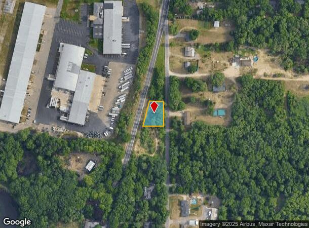
Property Record
8506 Division Ct Se, Byron Center, MI 49315
NEARBY LISTINGS FOR SALE OR LEASE
Property Detail
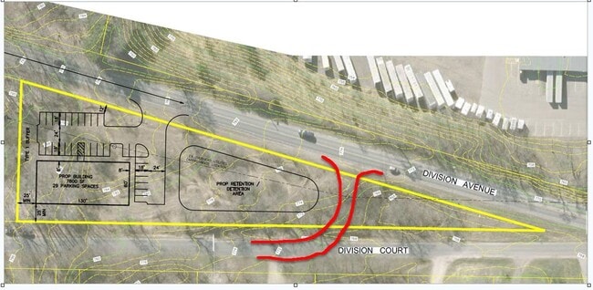
8506 Division Ct Se
Grand Rapids-Wyoming, MI
Lying E Of E Line Of Division
41-21-24-200-018
N 140 FT OF S 650 FT OF THAT PART OF NE 1/4 NE 1/4 LYING E OF E LINE OF DIVISION AVE * SEC 24 T5N R12W 0.43 A.
Residentialacreage
Kent
X
Michigan
26005C0125G
0.43 AC
2024
Byron/Gaines
2025
West Michigan
014803
DEMOGRAPHICS near 8506 Division Ct Se
1 Mile
3 Mile
5 Mile
2024 Total Population
2,466
33,198
88,227
2029 Population
2,529
33,547
89,251
Pop Growth 2024-2029
+ 2.55%
+ 1.05%
+ 1.16%
Average Age
39
39
38
2024 Total Households
912
12,041
31,945
HH Growth 2024-2029
+ 2.63%
+ 1.06%
+ 1.16%
Median Household Inc
$93,138
$78,578
$73,511
Avg Household Size
2.70
2.70
2.70
2024 Avg HH Vehicles
2.00
2.00
2.00
Median Home Value
$312,132
$272,097
$249,927
Median Year Built
2002
1993
1988
Nearby Places
Map Layers
Map Styles
 Street
 Aerial
- Restaurants
- Banks
- Shops
- Fitness
- Groceries
PUBLIC TRANSPORTATION
AIRPORT
Gerald R Ford International
DRIVE
WALK
Distance
Gerald R Ford International
21 min
12.9 mi
Freight Ports
Port Milwaukee
DRIVE
WALK
Distance
Port Milwaukee
306 min
261.8 mi
SALE & LEASE HISTORY
LISTING DATE
SALE/LEASE

Mar 11, 2024
For Sale
Nearby Properties
Address
Land Use
TOTAL SIZE
Lot Size
Zoning
Address
Land Use
TOTAL SIZE
Lot Size
Zoning
490,769 SF
42.25 AC
B3
Address
Land Use
TOTAL SIZE
Lot Size
Zoning
63,788 SF
124.62 AC
D1
Address
Land Use
TOTAL SIZE
Lot Size
Zoning
487,739 SF
73.87 AC
RR
Address
Land Use
TOTAL SIZE
Lot Size
Zoning
38.98 AC
PUD-PL UNI
Address
Land Use
TOTAL SIZE
Lot Size
Zoning
58.30 AC
RA
Address
Land Use
TOTAL SIZE
Lot Size
Zoning
720 SF
74.47 AC
R4-MOBILE
Address
Land Use
TOTAL SIZE
Lot Size
Zoning
108,911 SF
10.80 AC
D1
Address
Land Use
TOTAL SIZE
Lot Size
Zoning
1,296 SF
12 AC
PUD-PL UNI
Address
Land Use
TOTAL SIZE
Lot Size
Zoning
140,742 SF
18.57 AC
D1
Address
Land Use
TOTAL SIZE
Lot Size
Zoning
49.29 AC
R4-MOBILE
Address
Land Use
TOTAL SIZE
Lot Size
Zoning
48.57 AC
RD
Address
Land Use
TOTAL SIZE
Lot Size
Zoning
45.66 AC
RD
Address
Land Use
TOTAL SIZE
Lot Size
Zoning
Address
Land Use
TOTAL SIZE
Lot Size
Zoning
22.37 AC
Address
Land Use
TOTAL SIZE
Lot Size
Zoning
201,500 SF
11.98 AC
D1
Address
Land Use
TOTAL SIZE
Lot Size
Zoning
Address
Land Use
TOTAL SIZE
Lot Size
Zoning
Address
Land Use
TOTAL SIZE
Lot Size
Zoning
31.20 AC
R4-MOBILE
Address
Land Use
TOTAL SIZE
Lot Size
Zoning
205,000 SF
9.88 AC
D1
Address
Land Use
TOTAL SIZE
Lot Size
Zoning
4.74 AC
D1PUD
Address
Land Use
TOTAL SIZE
Lot Size
Zoning
96,550 SF
19.95 AC
D1
Address
Land Use
TOTAL SIZE
Lot Size
Zoning
Address
Land Use
TOTAL SIZE
Lot Size
Zoning
36.87 AC
RD
Address
Land Use
TOTAL SIZE
Lot Size
Zoning
55,110 SF
18.45 AC
Address
Land Use
TOTAL SIZE
Lot Size
Zoning
45,423 SF
6.25 AC
D1
Address
Land Use
TOTAL SIZE
Lot Size
Zoning
189,537 SF
43.04 AC
D1
Address
Land Use
TOTAL SIZE
Lot Size
Zoning
210,000 SF
15.71 AC
D1
Address
Land Use
TOTAL SIZE
Lot Size
Zoning
Address
Land Use
TOTAL SIZE
Lot Size
Zoning
1,428 SF
7.75 AC
D1
Address
Land Use
TOTAL SIZE
Lot Size
Zoning
111,600 SF
The World's #1 Commercial Real Estate Marketplace
Connect with us
© 2025 CoStar Group
The information above has been obtained from sources believed reliable. While we do not doubt its accuracy we have not verified it and make no guarantee, warranty or representation about it. It is your responsibility to independently confirm its accuracy and completeness. Any projections, opinions, assumptions, or estimates used are for example only and do not represent the current or future performance of the property. The value of this transaction to you depends on tax and other factors which should be evaluated by your tax, financial, and legal advisors. You and your advisors should conduct a careful, independent investigation of the property to determine to your satisfaction the suitability of the property for your needs.