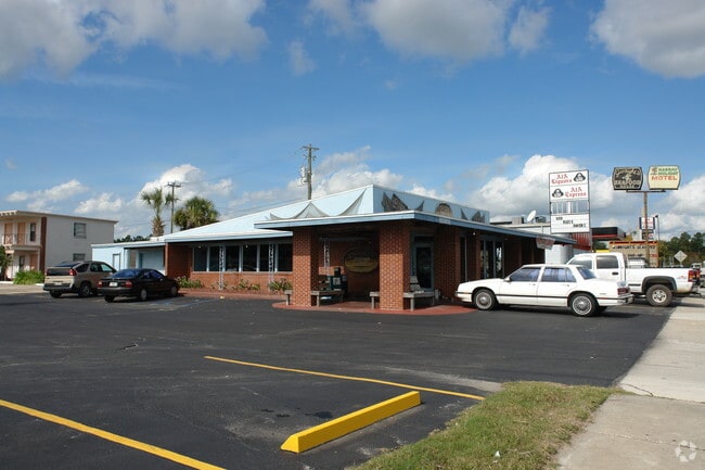
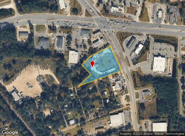
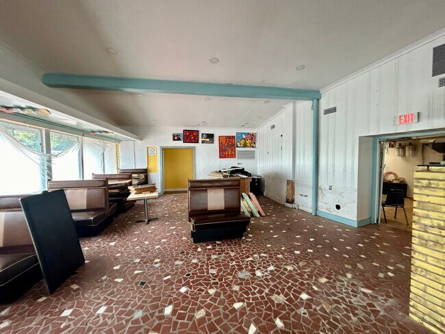
Property Record
850857 Us Highway 17, Yulee, FL 32097
NEARBY LISTINGS FOR SALE OR LEASE
Property Detail
850857 Us Highway 17
Jacksonville, FL
East Yulee
42-2N-27-0000-0053-0000
PARCEL 53 & LOTS 14 15 & 16 IN OR 972/1891 EAST YULEE
Hotel
Nassau
X
Florida
12089C0215G
14
2025
2.33 AC
2025
Nassau County
050304
Jacksonville (Florida)
14,020 SF
DEMOGRAPHICS near 850857 Us Highway 17
1 Mile
3 Mile
5 Mile
2024 Total Population
2,629
12,899
32,518
2029 Population
3,225
15,656
39,265
Pop Growth 2024-2029
+ 22.67%
+ 21.37%
+ 20.75%
Average Age
40
41
41
2024 Total Households
998
4,796
12,160
HH Growth 2024-2029
+ 23.85%
+ 22.56%
+ 21.99%
Median Household Inc
$72,428
$71,701
$77,967
Avg Household Size
2.60
2.60
2.60
2024 Avg HH Vehicles
2.00
2.00
2.00
Median Home Value
$239,959
$247,229
$280,035
Median Year Built
2006
2004
2007
Nearby Places
- Restaurants
- Banks
- Shops
- Fitness
- Groceries
PUBLIC TRANSPORTATION
AIRPORT
Jacksonville International
DRIVE
WALK
Distance
Jacksonville International
23 min
13.6 mi
Freight Ports
Jacksonville Port
DRIVE
WALK
Distance
Jacksonville Port
33 min
23.9 mi
SALE & LEASE HISTORY
LISTING DATE
SALE/LEASE

May 08, 2020
For Lease
Nearby Properties
Address
Land Use
TOTAL SIZE
Lot Size
Zoning
Address
Land Use
TOTAL SIZE
Lot Size
Zoning
249,913 SF
160.04 AC
OR
Address
Land Use
TOTAL SIZE
Lot Size
Zoning
297,748 SF
92.23 AC
OR
Address
Land Use
TOTAL SIZE
Lot Size
Zoning
306,222 SF
21.65 AC
PD - ENCPA
Address
Land Use
TOTAL SIZE
Lot Size
Zoning
291,580 SF
12.56 AC
PD - ENCPA
Address
Land Use
TOTAL SIZE
Lot Size
Zoning
327,682 SF
24.09 AC
RG-2
Address
Land Use
TOTAL SIZE
Lot Size
Zoning
282,898 SF
22.88 AC
RG-2
Address
Land Use
TOTAL SIZE
Lot Size
Zoning
302,387 SF
29.60 AC
PD - ENCPA
Address
Land Use
TOTAL SIZE
Lot Size
Zoning
493,661 SF
49.08 AC
PUD
Address
Land Use
TOTAL SIZE
Lot Size
Zoning
134,139 SF
27.49 AC
PD - ENCPA
Address
Land Use
TOTAL SIZE
Lot Size
Zoning
91,196 SF
86.52 AC
OR
Address
Land Use
TOTAL SIZE
Lot Size
Zoning
112,634 SF
16 AC
GPU
Address
Land Use
TOTAL SIZE
Lot Size
Zoning
83,799 SF
13.18 AC
PD - ENCPA
Address
Land Use
TOTAL SIZE
Lot Size
Zoning
42,189 SF
7.69 AC
PD - ENCPA
Address
Land Use
TOTAL SIZE
Lot Size
Zoning
11,151 SF
55.27 AC
CI
Address
Land Use
TOTAL SIZE
Lot Size
Zoning
92,327 SF
22.06 AC
OR
Address
Land Use
TOTAL SIZE
Lot Size
Zoning
23,934 SF
20.45 AC
CN
Address
Land Use
TOTAL SIZE
Lot Size
Zoning
13,472 SF
Address
Land Use
TOTAL SIZE
Lot Size
Zoning
81,960 SF
2.90 AC
PD - ENCPA
Address
Land Use
TOTAL SIZE
Lot Size
Zoning
59,703 SF
12.06 AC
GPU
Address
Land Use
TOTAL SIZE
Lot Size
Zoning
38,211 SF
5.54 AC
PD - ENCPA
Address
Land Use
TOTAL SIZE
Lot Size
Zoning
125,733 SF
10.89 AC
IW
Address
Land Use
TOTAL SIZE
Lot Size
Zoning
12,594 SF
Address
Land Use
TOTAL SIZE
Lot Size
Zoning
25,920 SF
14.72 AC
GPU
Address
Land Use
TOTAL SIZE
Lot Size
Zoning
89.52 AC
PD - ENCPA
Address
Land Use
TOTAL SIZE
Lot Size
Zoning
41,762 SF
1.93 AC
CHT
Address
Land Use
TOTAL SIZE
Lot Size
Zoning
95,332 SF
23.03 AC
PUD
Address
Land Use
TOTAL SIZE
Lot Size
Zoning
33,733 SF
2.78 AC
CHT
Address
Land Use
TOTAL SIZE
Lot Size
Zoning
16,518 SF
23.33 AC
PD - ENCPA
Address
Land Use
TOTAL SIZE
Lot Size
Zoning
83.12 AC
PD - ENCPA
Address
Land Use
TOTAL SIZE
Lot Size
Zoning
18,750 SF
4.58 AC
CI
The World's #1 Commercial Real Estate Marketplace
Connect with us
© 2025 CoStar Group
The information above has been obtained from sources believed reliable. While we do not doubt its accuracy we have not verified it and make no guarantee, warranty or representation about it. It is your responsibility to independently confirm its accuracy and completeness. Any projections, opinions, assumptions, or estimates used are for example only and do not represent the current or future performance of the property. The value of this transaction to you depends on tax and other factors which should be evaluated by your tax, financial, and legal advisors. You and your advisors should conduct a careful, independent investigation of the property to determine to your satisfaction the suitability of the property for your needs.