Property Record
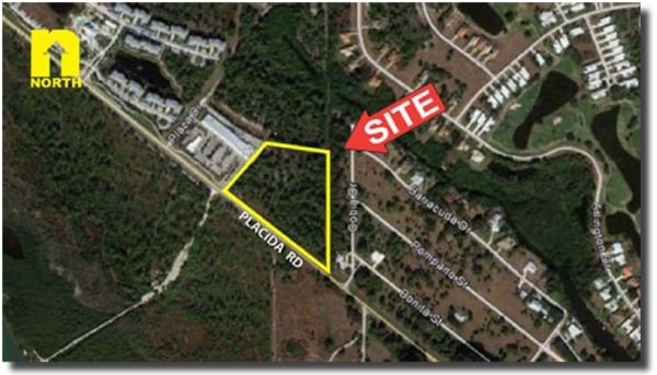
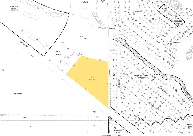
8509 Placida Rd, Placida, FL 33946

Property Detail
8509 Placida Rd
412034377003
34 41 20 TR 17 7.146 AC. M/L COMM AT NE COR OF SW1/4 THE S 1819.94 FT FOR POB TH CONT S 724.7 FT TO N ROW CR 775 TH NW ALR ROW 841.81 FT NE 386.83 FT SE/LY 230 FT E 220.87 FT TO POB 575/1921 610/1757 610/1761 614/453 769/1529 818/324 933
Commercialacreage
CHARLOTTE
CG
Florida
AE The base floodplain where base flood elevations are provided. AE Zones are now used on new format FIRMs instead of A1-A30 Zones.
7.15 AC
2024
Charlotte County
2025
Southwest Florida
030504
Punta Gorda, FL
NEARBY LISTINGS FOR SALE OR LEASE
DEMOGRAPHICS near 8509 Placida Rd
1 mile
3 mile
5 mile
2025 Total Population
1,488
9,972
29,133
2030 Population
1,658
11,129
32,510
Pop Growth 2025-2030
+ 11.42%
+ 11.60%
+ 11.59%
Average Age
63
61
59
2025 Total Households
798
5,124
14,342
HH Growth 2025-2030
+ 11.28%
+ 11.46%
+ 11.49%
Median Household Inc
$81,426
$77,186
$78,636
Avg Household Size
1.90
1.90
2.00
2025 Avg HH Vehicles
2.00
2.00
2.00
Median Home Value
$546,032
$390,236
$418,989
Median Year Built
1990
1991
1997
Nearby Places
Map Layers
Map Styles
 Street
 Aerial
Transit
 Traffic
 Biking
Places
Listings with unknown addresses are not visible on the map
- Restaurants
- Banks
- Shops
- Fitness
- Groceries
PUBLIC TRANSPORTATION
AIRPORT
Punta Gorda
Drive
Walk
Distance
Punta Gorda
52 min
31.3 mi
SALE & LEASE HISTORY
LISTING DATE
SALE/LEASE

Feb 06, 2018
For Sale
Nearby Properties
Address
Land Use
TOTAL SIZE
Lot Size
Zoning
Address
Land Use
TOTAL SIZE
Lot Size
Zoning
2,387.99 AC
ES
Address
Land Use
TOTAL SIZE
Lot Size
Zoning
105,990 SF
17.30 AC
RMF15
Address
Land Use
TOTAL SIZE
Lot Size
Zoning
70,336 SF
29.71 AC
II
Address
Land Use
TOTAL SIZE
Lot Size
Zoning
38,036 SF
9.09 AC
RMF15
Address
Land Use
TOTAL SIZE
Lot Size
Zoning
32,041 SF
202.06 AC
CT
Address
Land Use
TOTAL SIZE
Lot Size
Zoning
101,160 SF
2.39 AC
CG
Address
Land Use
TOTAL SIZE
Lot Size
Zoning
42,935 SF
167.66 AC
RE1
Address
Land Use
TOTAL SIZE
Lot Size
Zoning
2,473 SF
26.16 AC
PUBLIC
Address
Land Use
TOTAL SIZE
Lot Size
Zoning
4,742 SF
13.09 AC
PD
Address
Land Use
TOTAL SIZE
Lot Size
Zoning
25,685 SF
126.18 AC
RMF-T
Address
Land Use
TOTAL SIZE
Lot Size
Zoning
98,534 SF
24.84 AC
CG
Address
Land Use
TOTAL SIZE
Lot Size
Zoning
4,326 SF
31.99 AC
MHP
Address
Land Use
TOTAL SIZE
Lot Size
Zoning
14.21 AC
II
Address
Land Use
TOTAL SIZE
Lot Size
Zoning
324 SF
11.52 AC
CT
Address
Land Use
TOTAL SIZE
Lot Size
Zoning
40,376 SF
11.18 AC
CG
Address
Land Use
TOTAL SIZE
Lot Size
Zoning
24,708 SF
14.89 AC
CT
Address
Land Use
TOTAL SIZE
Lot Size
Zoning
3,935 SF
36.92 AC
RMF10
Address
Land Use
TOTAL SIZE
Lot Size
Zoning
50,080 SF
5.09 AC
CG
Address
Land Use
TOTAL SIZE
Lot Size
Zoning
15.79 AC
CT
Address
Land Use
TOTAL SIZE
Lot Size
Zoning
5.61 AC
II
Address
Land Use
TOTAL SIZE
Lot Size
Zoning
25,130 SF
21.98 AC
RE1
Address
Land Use
TOTAL SIZE
Lot Size
Zoning
27,501 SF
3.82 AC
CG
Address
Land Use
TOTAL SIZE
Lot Size
Zoning
20,160 SF
3.04 AC
CG
Address
Land Use
TOTAL SIZE
Lot Size
Zoning
5,980 SF
0.40 AC
BBI
Address
Land Use
TOTAL SIZE
Lot Size
Zoning
15,190 SF
154.40 AC
RSF5
Address
Land Use
TOTAL SIZE
Lot Size
Zoning
8.47 AC
RMF10
Address
Land Use
TOTAL SIZE
Lot Size
Zoning
33.01 AC
CG
Address
Land Use
TOTAL SIZE
Lot Size
Zoning
10 AC
RMF10
Address
Land Use
TOTAL SIZE
Lot Size
Zoning
18.62 AC
RMF15
Address
Land Use
TOTAL SIZE
Lot Size
Zoning
25,827 SF
9.34 AC
RMF15
The World's #1 Commercial Real Estate Marketplace
Connect with us
© 2026 CoStar Group
The information above has been obtained from sources believed reliable. While we do not doubt its accuracy we have not verified it and make no guarantee, warranty or representation about it. It is your responsibility to independently confirm its accuracy and completeness. Any projections, opinions, assumptions, or estimates used are for example only and do not represent the current or future performance of the property. The value of this transaction to you depends on tax and other factors which should be evaluated by your tax, financial, and legal advisors. You and your advisors should conduct a careful, independent investigation of the property to determine to your satisfaction the suitability of the property for your needs.