Property Record
851 Sterling Rd, Lancaster, MA 01523
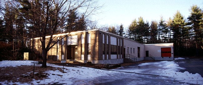

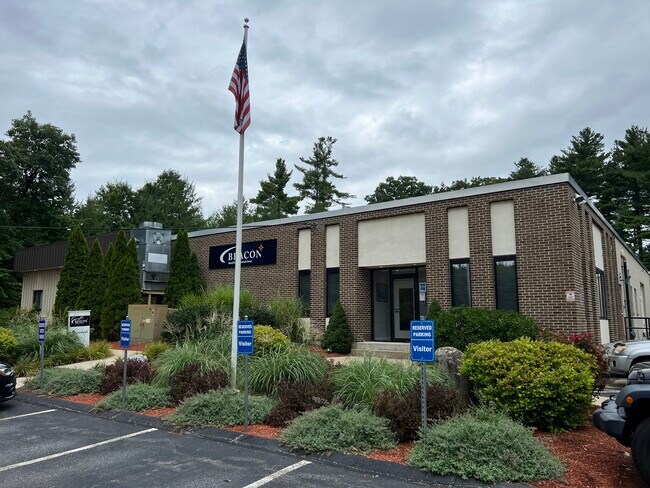
Property Detail
851 Sterling Rd
LANC-000360-000000-000014A
Worcester
Manufacturinglight
Massachusetts
B and X Area of moderate flood hazard, usually the area between the limits of the 100-year and 500-year floods.
14.a
2025
2 AC
2025
Outlying Worcester
713100
Boston
23,280 SF
Worcester, MA
NEARBY LISTINGS FOR SALE OR LEASE
DEMOGRAPHICS near 851 Sterling Rd
1 mile
3 mile
5 mile
2025 Total Population
1,271
24,535
44,315
2030 Population
1,306
25,179
45,543
Pop Growth 2025-2030
+ 2.75%
+ 2.62%
+ 2.77%
Average Age
45
42
43
2025 Total Households
475
9,718
17,425
HH Growth 2025-2030
+ 2.74%
+ 2.64%
+ 2.84%
Median Household Inc
$146,205
$100,812
$105,159
Avg Household Size
2.70
2.40
2.40
2025 Avg HH Vehicles
2.00
2.00
2.00
Median Home Value
$660,577
$444,625
$451,311
Median Year Built
1993
1961
1971
Nearby Places
Map Layers
Map Styles
 Street
 Aerial
Layers
 Traffic
 Biking
Places
Listings with unknown addresses are not visible on the map
- Restaurants
- Banks
- Shops
- Fitness
- Groceries
PUBLIC TRANSPORTATION
COMMUTER RAIL
North Leominster (Fitchburg/South Acton Line - Massachusetts Bay Transportation Authority Commuter Rail (Purple Line))
Drive
Walk
Distance
North Leominster (Fitchburg/South Acton Line - Massachusetts Bay Transportation Authority Commuter Rail (Purple Line))
14 min
9.2 mi
AIRPORT
Worcester Regional
Drive
Walk
Distance
Worcester Regional
35 min
23.0 mi
Freight Ports
Port of Boston
Drive
Walk
Distance
Port of Boston
71 min
49.7 mi
SALE & LEASE HISTORY
LISTING DATE
SALE/LEASE

Oct 18, 2022
For Lease
Nearby Properties
Address
Land Use
TOTAL SIZE
Lot Size
Zoning
Address
Land Use
TOTAL SIZE
Lot Size
Zoning
26.80 AC
Address
Land Use
TOTAL SIZE
Lot Size
Zoning
344,000 SF
20.63 AC
Address
Land Use
TOTAL SIZE
Lot Size
Zoning
168,653 SF
6.50 AC
Address
Land Use
TOTAL SIZE
Lot Size
Zoning
455,636 SF
54.47 AC
Address
Land Use
TOTAL SIZE
Lot Size
Zoning
85,557 SF
9.27 AC
Address
Land Use
TOTAL SIZE
Lot Size
Zoning
64,497 SF
3.27 AC
Address
Land Use
TOTAL SIZE
Lot Size
Zoning
128,324 SF
1.03 AC
Address
Land Use
TOTAL SIZE
Lot Size
Zoning
174,412 SF
Address
Land Use
TOTAL SIZE
Lot Size
Zoning
12.69 AC
Address
Land Use
TOTAL SIZE
Lot Size
Zoning
2.37 AC
Address
Land Use
TOTAL SIZE
Lot Size
Zoning
147,092 SF
36.90 AC
Address
Land Use
TOTAL SIZE
Lot Size
Zoning
119,038 SF
12.17 AC
Address
Land Use
TOTAL SIZE
Lot Size
Zoning
16,504 SF
0.45 AC
Address
Land Use
TOTAL SIZE
Lot Size
Zoning
5,050 SF
11.92 AC
Address
Land Use
TOTAL SIZE
Lot Size
Zoning
2.07 AC
Address
Land Use
TOTAL SIZE
Lot Size
Zoning
4,536 SF
48.38 AC
Address
Land Use
TOTAL SIZE
Lot Size
Zoning
158,900 SF
80 AC
Address
Land Use
TOTAL SIZE
Lot Size
Zoning
48,240 SF
0.59 AC
Address
Land Use
TOTAL SIZE
Lot Size
Zoning
116,116 SF
53.90 AC
Address
Land Use
TOTAL SIZE
Lot Size
Zoning
133,068 SF
9 AC
Address
Land Use
TOTAL SIZE
Lot Size
Zoning
1.61 AC
Address
Land Use
TOTAL SIZE
Lot Size
Zoning
33,050 SF
7.80 AC
Address
Land Use
TOTAL SIZE
Lot Size
Zoning
70,516 SF
23 AC
Address
Land Use
TOTAL SIZE
Lot Size
Zoning
12.66 AC
Address
Land Use
TOTAL SIZE
Lot Size
Zoning
0.01 AC
Address
Land Use
TOTAL SIZE
Lot Size
Zoning
7,344 SF
Address
Land Use
TOTAL SIZE
Lot Size
Zoning
60.46 AC
Address
Land Use
TOTAL SIZE
Lot Size
Zoning
26,939 SF
0.75 AC
Address
Land Use
TOTAL SIZE
Lot Size
Zoning
1.81 AC
Address
Land Use
TOTAL SIZE
Lot Size
Zoning
24,776 SF
13.58 AC
The World's #1 Commercial Real Estate Marketplace
Connect with us
© 2026 CoStar Group
The information above has been obtained from sources believed reliable. While we do not doubt its accuracy we have not verified it and make no guarantee, warranty or representation about it. It is your responsibility to independently confirm its accuracy and completeness. Any projections, opinions, assumptions, or estimates used are for example only and do not represent the current or future performance of the property. The value of this transaction to you depends on tax and other factors which should be evaluated by your tax, financial, and legal advisors. You and your advisors should conduct a careful, independent investigation of the property to determine to your satisfaction the suitability of the property for your needs.