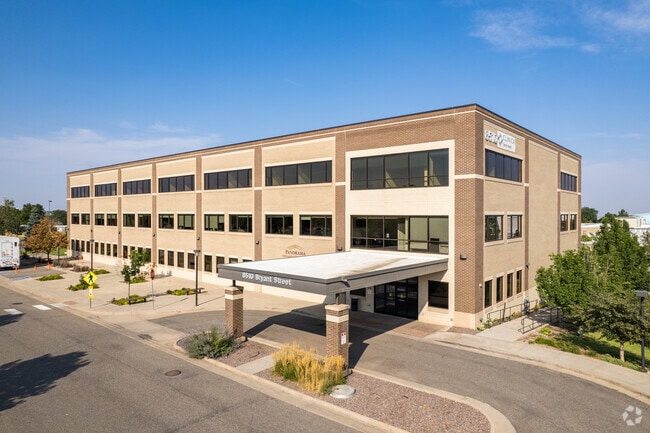
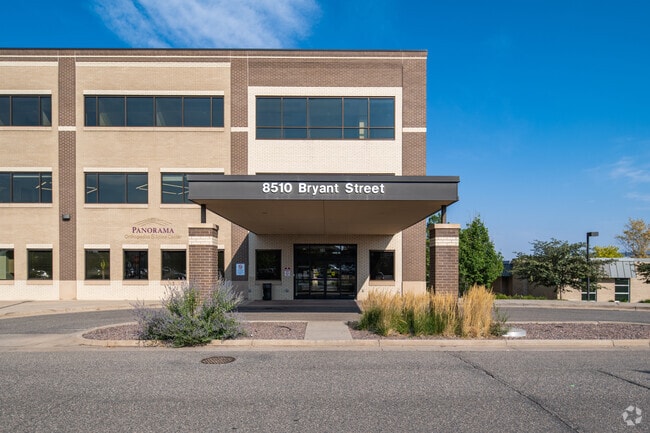
Property Record
8510 Bryant St, Westminster, CO 80031


Current Lease Availabilities
Property Detail
8510 Bryant St
Denver-Aurora-Centennial, CO
IMPS ONLY: BEING PT OF TRACT A ST ANTHONY NORTH HOSPITAL SUBD, PREVIOUSLY PT OF GREENBRIAR 1 SUBD LOCATED IN THE NE4 OF SEC 29/2/68 DESC AS FOLS BEG AT THE CEN QTR COR SEC 29 WHERE THE E4 OF SEC 29 BRS N 89D 53M 56S E 2691/43 FT TH N 89D 53M 56S E 15
1719-29-1-01-002
Adams
Officebuilding
Colorado
2024
0.65 AC
2025
North Denver
009320
Denver
64,500 SF
NEARBY LISTINGS FOR SALE OR LEASE
DEMOGRAPHICS near 8510 Bryant St
1 mile
3 mile
5 mile
2025 Total Population
22,069
160,451
336,856
2030 Population
22,773
165,114
344,819
Pop Growth 2025-2030
+ 3.19%
+ 2.91%
+ 2.36%
Average Age
36
38
38
2025 Total Households
8,004
58,648
126,764
HH Growth 2025-2030
+ 3.55%
+ 3.10%
+ 2.46%
Median Household Inc
$67,781
$81,787
$89,914
Avg Household Size
2.70
2.70
2.60
2025 Avg HH Vehicles
2.00
2.00
2.00
Median Home Value
$407,789
$455,358
$484,237
Median Year Built
1978
1977
1979
Nearby Places
Map Layers
Map Styles
 Street
 Aerial
Transit
 Traffic
 Biking
Places
Listings with unknown addresses are not visible on the map
- Restaurants
- Banks
- Shops
- Fitness
- Groceries
PUBLIC TRANSPORTATION
COMMUTER RAIL
Drive
Walk
Distance
6 min
2.4 mi
Drive
Walk
Distance
8 min
2.8 mi
AIRPORT
Denver International
Drive
Walk
Distance
Denver International
36 min
27.1 mi
Nearby Properties
Address
Land Use
TOTAL SIZE
Lot Size
Zoning
Address
Land Use
TOTAL SIZE
Lot Size
Zoning
21,306 SF
2.43 AC
Address
Land Use
TOTAL SIZE
Lot Size
Zoning
271,631 SF
12.84 AC
Address
Land Use
TOTAL SIZE
Lot Size
Zoning
216,285 SF
6 AC
Address
Land Use
TOTAL SIZE
Lot Size
Zoning
208,500 SF
8.42 AC
Address
Land Use
TOTAL SIZE
Lot Size
Zoning
138,770 SF
4.64 AC
Address
Land Use
TOTAL SIZE
Lot Size
Zoning
140,430 SF
8.39 AC
Address
Land Use
TOTAL SIZE
Lot Size
Zoning
138,912 SF
8.71 AC
Address
Land Use
TOTAL SIZE
Lot Size
Zoning
261,540 SF
19.23 AC
Address
Land Use
TOTAL SIZE
Lot Size
Zoning
170,210 SF
9 AC
Address
Land Use
TOTAL SIZE
Lot Size
Zoning
113,385 SF
6.77 AC
Address
Land Use
TOTAL SIZE
Lot Size
Zoning
398,180 SF
33.31 AC
R1C
Address
Land Use
TOTAL SIZE
Lot Size
Zoning
58,750 SF
1.52 AC
Address
Land Use
TOTAL SIZE
Lot Size
Zoning
86,816 SF
4.95 AC
Address
Land Use
TOTAL SIZE
Lot Size
Zoning
79,636 SF
4.91 AC
Address
Land Use
TOTAL SIZE
Lot Size
Zoning
305,110 SF
16.87 AC
Address
Land Use
TOTAL SIZE
Lot Size
Zoning
74,106 SF
3.95 AC
PUD
Address
Land Use
TOTAL SIZE
Lot Size
Zoning
110,878 SF
4.65 AC
Address
Land Use
TOTAL SIZE
Lot Size
Zoning
105,600 SF
1.31 AC
Address
Land Use
TOTAL SIZE
Lot Size
Zoning
65,336 SF
2.86 AC
Address
Land Use
TOTAL SIZE
Lot Size
Zoning
64,106 SF
4.10 AC
Address
Land Use
TOTAL SIZE
Lot Size
Zoning
74,432 SF
4.47 AC
Address
Land Use
TOTAL SIZE
Lot Size
Zoning
309,126 SF
5.75 AC
Address
Land Use
TOTAL SIZE
Lot Size
Zoning
147,009 SF
36.94 AC
I3
Address
Land Use
TOTAL SIZE
Lot Size
Zoning
69,537 SF
4.49 AC
Address
Land Use
TOTAL SIZE
Lot Size
Zoning
141,124 SF
22.35 AC
Address
Land Use
TOTAL SIZE
Lot Size
Zoning
10,883 SF
4.54 AC
Address
Land Use
TOTAL SIZE
Lot Size
Zoning
51,312 SF
2.17 AC
PUD
Address
Land Use
TOTAL SIZE
Lot Size
Zoning
53,602 SF
2.37 AC
Address
Land Use
TOTAL SIZE
Lot Size
Zoning
674,481 SF
21.06 AC
Address
Land Use
TOTAL SIZE
Lot Size
Zoning
317,619 SF
32.28 AC
The World's #1 Commercial Real Estate Marketplace
Connect with us
© 2026 CoStar Group
The information above has been obtained from sources believed reliable. While we do not doubt its accuracy we have not verified it and make no guarantee, warranty or representation about it. It is your responsibility to independently confirm its accuracy and completeness. Any projections, opinions, assumptions, or estimates used are for example only and do not represent the current or future performance of the property. The value of this transaction to you depends on tax and other factors which should be evaluated by your tax, financial, and legal advisors. You and your advisors should conduct a careful, independent investigation of the property to determine to your satisfaction the suitability of the property for your needs.