Property Record
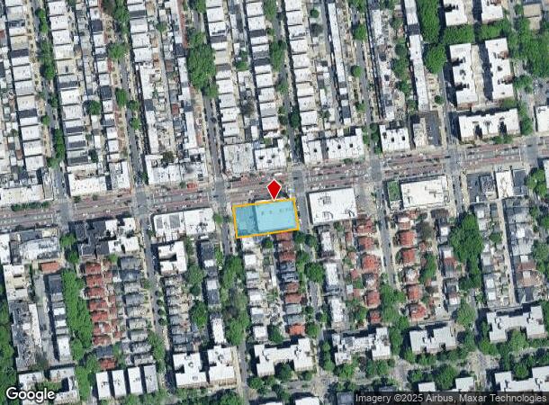
8510 Northern Blvd, Jackson Heights, NY 11372


Current Lease Availabilities
NEARBY LISTINGS FOR SALE OR LEASE
Property Detail
8510 Northern Blvd
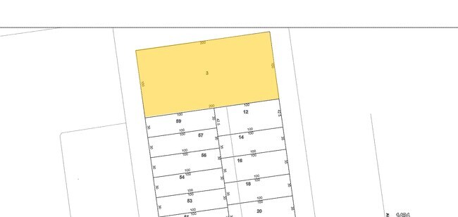
01433-0003
Map Barclay Dugro Tract Queens Corp 2Nd
Storebuilding
Queens
X
New York
3604970094F
3
2024
0.46 AC
2025
Northeast Queens
028100
Long Island (New York)
13,896 SF
New York-Jersey City-White Plains, NY-NJ
DEMOGRAPHICS near 8510 Northern Blvd
1 Mile
3 Mile
5 Mile
2024 Total Population
199,519
829,380
2,285,733
2029 Population
186,545
779,433
2,137,153
Pop Growth 2024-2029
(6.50%)
(6.02%)
(6.50%)
Average Age
40
41
40
2024 Total Households
63,859
305,029
902,110
HH Growth 2024-2029
(6.50%)
(6.06%)
(6.71%)
Median Household Inc
$63,206
$71,088
$73,201
Avg Household Size
3.00
2.60
2.40
2024 Avg HH Vehicles
1.00
1.00
1.00
Median Home Value
$596,583
$668,358
$761,223
Median Year Built
1950
1953
1955
Nearby Places
Map Layers
Map Styles
 Street
 Aerial
- Restaurants
- Banks
- Shops
- Fitness
- Groceries
PUBLIC TRANSPORTATION
TRANSIT/SUBWAY
82 Street-Jackson Heights (7 - New York MTA Subway (The Subway))
DRIVE
WALK
Distance
82 Street-Jackson Heights (7 - New York MTA Subway (The Subway))
3 min
14 min
0.7 mi
90 Street-Elmhurst Avenue (7 - New York MTA Subway (The Subway))
DRIVE
WALK
Distance
90 Street-Elmhurst Avenue (7 - New York MTA Subway (The Subway))
3 min
14 min
0.7 mi
Junction Boulevard (7 - New York MTA Subway (The Subway))
DRIVE
WALK
Distance
Junction Boulevard (7 - New York MTA Subway (The Subway))
4 min
19 min
1.0 mi
COMMUTER RAIL
Woodside Station (Babylon Branch - Long Island Rail Road, Far Rockaway Branch - Long Island Rail Road, Hempstead Branch - Long Island Rail Road, Long Beach Branch - Long Island Rail Road, Montauk Branch - Long Island Rail Road, Port Jefferson Branch - Long Island Rail Road, Port Washington Branch - Long Island Rail Road, Ronkonkoma Branch - Long Island Rail Road)
DRIVE
WALK
Distance
Woodside Station (Babylon Branch - Long Island Rail Road, Far Rockaway Branch - Long Island Rail Road, Hempstead Branch - Long Island Rail Road, Long Beach Branch - Long Island Rail Road, Montauk Branch - Long Island Rail Road, Port Jefferson Branch - Long Island Rail Road, Port Washington Branch - Long Island Rail Road, Ronkonkoma Branch - Long Island Rail Road)
4 min
1.8 mi
Mets-Willets Point Station (Port Washington Branch - Long Island Rail Road)
DRIVE
WALK
Distance
Mets-Willets Point Station (Port Washington Branch - Long Island Rail Road)
9 min
3.0 mi
AIRPORT
LaGuardia
DRIVE
WALK
Distance
LaGuardia
6 min
1.8 mi
John F Kennedy International
DRIVE
WALK
Distance
John F Kennedy International
18 min
11.5 mi
Newark Liberty International
DRIVE
WALK
Distance
Newark Liberty International
35 min
21.3 mi
Freight Ports
NY - Red Hook Container Terminal
DRIVE
WALK
Distance
NY - Red Hook Container Terminal
19 min
10.0 mi
Nearby Properties
Address
Land Use
TOTAL SIZE
Lot Size
Zoning
Address
Land Use
TOTAL SIZE
Lot Size
Zoning
5,519,372 SF
409.21 AC
C8-2
Address
Land Use
TOTAL SIZE
Lot Size
Zoning
1,258,350 SF
410.24 AC
PARK
Address
Land Use
TOTAL SIZE
Lot Size
Zoning
1,065,915 SF
2.13 AC
M16R10
Address
Land Use
TOTAL SIZE
Lot Size
Zoning
1,502,532 SF
6.35 AC
R7B
Address
Land Use
TOTAL SIZE
Lot Size
Zoning
772,163 SF
5.24 AC
C4-5X
Address
Land Use
TOTAL SIZE
Lot Size
Zoning
1,292,074 SF
C4-2F
Address
Land Use
TOTAL SIZE
Lot Size
Zoning
234,891 SF
3.17 AC
C4-5X
Address
Land Use
TOTAL SIZE
Lot Size
Zoning
882,579 SF
0.51 AC
M16R10
Address
Land Use
TOTAL SIZE
Lot Size
Zoning
1,516,458 SF
5.97 AC
R7-1
Address
Land Use
TOTAL SIZE
Lot Size
Zoning
217,951 SF
0.91 AC
R6
Address
Land Use
TOTAL SIZE
Lot Size
Zoning
753,206 SF
5.30 AC
R6
Address
Land Use
TOTAL SIZE
Lot Size
Zoning
524,716 SF
1.60 AC
M16R10
Address
Land Use
TOTAL SIZE
Lot Size
Zoning
1,000 SF
210.07 AC
R3-2
Address
Land Use
TOTAL SIZE
Lot Size
Zoning
332,266 SF
12.57 AC
M2-1
Address
Land Use
TOTAL SIZE
Lot Size
Zoning
512,815 SF
0.63 AC
M16R10
Address
Land Use
TOTAL SIZE
Lot Size
Zoning
344,116 SF
0.92 AC
R7-1
Address
Land Use
TOTAL SIZE
Lot Size
Zoning
360,000 SF
5.88 AC
C4-2
Address
Land Use
TOTAL SIZE
Lot Size
Zoning
480,000 SF
16.98 AC
M1-1
Address
Land Use
TOTAL SIZE
Lot Size
Zoning
248,200 SF
1.25 AC
R6
Address
Land Use
TOTAL SIZE
Lot Size
Zoning
250,577 SF
23.17 AC
M2-1
Address
Land Use
TOTAL SIZE
Lot Size
Zoning
550,909 SF
2.76 AC
M1-4
Address
Land Use
TOTAL SIZE
Lot Size
Zoning
595,000 SF
2.76 AC
M1-4
Address
Land Use
TOTAL SIZE
Lot Size
Zoning
266,195 SF
4.59 AC
C4-2
Address
Land Use
TOTAL SIZE
Lot Size
Zoning
272,081 SF
4.59 AC
C4-2
Address
Land Use
TOTAL SIZE
Lot Size
Zoning
240,000 SF
2.09 AC
R6
Address
Land Use
TOTAL SIZE
Lot Size
Zoning
281,416 SF
2.57 AC
C4-2
Address
Land Use
TOTAL SIZE
Lot Size
Zoning
182,842 SF
0.99 AC
M1-5
Address
Land Use
TOTAL SIZE
Lot Size
Zoning
316,075 SF
2.48 AC
M1-4
Address
Land Use
TOTAL SIZE
Lot Size
Zoning
192,200 SF
9.70 AC
R4
Address
Land Use
TOTAL SIZE
Lot Size
Zoning
207,407 SF
3.73 AC
R6B
The World's #1 Commercial Real Estate Marketplace
Connect with us
© 2026 CoStar Group
The information above has been obtained from sources believed reliable. While we do not doubt its accuracy we have not verified it and make no guarantee, warranty or representation about it. It is your responsibility to independently confirm its accuracy and completeness. Any projections, opinions, assumptions, or estimates used are for example only and do not represent the current or future performance of the property. The value of this transaction to you depends on tax and other factors which should be evaluated by your tax, financial, and legal advisors. You and your advisors should conduct a careful, independent investigation of the property to determine to your satisfaction the suitability of the property for your needs.