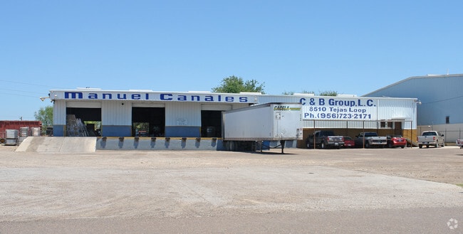
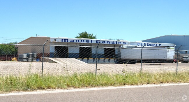
Property Record
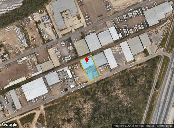
8510 Tejas Loop, Laredo, TX 78045
Property Detail
8510 Tejas Loop
221175
Tejas Industrial Park I
Commercialnec
LOT 10 TEJAS INDUSTRIAL PARK UNIT I
X
Webb
48479C1185C
Texas
2024
10
2025
1 AC
001717
Other Market Areas
13,609 SF
Laredo, TX
NEARBY LISTINGS FOR SALE OR LEASE
DEMOGRAPHICS near 8510 Tejas Loop
1 mile
3 mile
5 mile
2024 Total Population
7,316
70,449
144,370
2029 Population
7,447
71,215
145,791
Pop Growth 2024-2029
+ 1.79%
+ 1.09%
+ 0.98%
Average Age
35
36
35
2024 Total Households
2,379
22,437
44,996
HH Growth 2024-2029
+ 1.85%
+ 1.18%
+ 1.03%
Median Household Inc
$66,988
$70,425
$59,583
Avg Household Size
3.00
3.10
3.10
2024 Avg HH Vehicles
2.00
2.00
2.00
Median Home Value
$153,026
$192,018
$186,296
Median Year Built
2000
1998
1994
Nearby Places
Map Layers
Map Styles
 Street
 Aerial
Transit
 Traffic
 Biking
Places
Listings with unknown addresses are not visible on the map
- Restaurants
- Banks
- Shops
- Fitness
- Groceries
PUBLIC TRANSPORTATION
AIRPORT
Laredo International
Drive
Walk
Distance
Laredo International
17 min
7.1 mi
Nearby Properties
Address
Land Use
TOTAL SIZE
Lot Size
Zoning
Address
Land Use
TOTAL SIZE
Lot Size
Zoning
489,093 SF
32.23 AC
B4
Address
Land Use
TOTAL SIZE
Lot Size
Zoning
251,512 SF
57.32 AC
B4
Address
Land Use
TOTAL SIZE
Lot Size
Zoning
255,819 SF
50 AC
R1
Address
Land Use
TOTAL SIZE
Lot Size
Zoning
258,114 SF
30.54 AC
B1
Address
Land Use
TOTAL SIZE
Lot Size
Zoning
436,814 SF
27.66 AC
Address
Land Use
TOTAL SIZE
Lot Size
Zoning
562,944 SF
30 AC
M1
Address
Land Use
TOTAL SIZE
Lot Size
Zoning
227,503 SF
19.84 AC
B4
Address
Land Use
TOTAL SIZE
Lot Size
Zoning
370,800 SF
40.09 AC
Address
Land Use
TOTAL SIZE
Lot Size
Zoning
521,026 SF
30 AC
M1
Address
Land Use
TOTAL SIZE
Lot Size
Zoning
164,276 SF
43.92 AC
Address
Land Use
TOTAL SIZE
Lot Size
Zoning
286,008 SF
37.30 AC
Address
Land Use
TOTAL SIZE
Lot Size
Zoning
109,695 SF
3.73 AC
M1
Address
Land Use
TOTAL SIZE
Lot Size
Zoning
194,520 SF
11.18 AC
B3
Address
Land Use
TOTAL SIZE
Lot Size
Zoning
355,229 SF
15.41 AC
M1
Address
Land Use
TOTAL SIZE
Lot Size
Zoning
115,076 SF
32.87 AC
Address
Land Use
TOTAL SIZE
Lot Size
Zoning
192,203 SF
22.01 AC
B4
Address
Land Use
TOTAL SIZE
Lot Size
Zoning
218,415 SF
13.41 AC
R3
Address
Land Use
TOTAL SIZE
Lot Size
Zoning
203,922 SF
11 AC
R2
Address
Land Use
TOTAL SIZE
Lot Size
Zoning
122,752 SF
17.16 AC
R2
Address
Land Use
TOTAL SIZE
Lot Size
Zoning
170,632 SF
8.03 AC
B3
Address
Land Use
TOTAL SIZE
Lot Size
Zoning
257,516 SF
21.94 AC
Address
Land Use
TOTAL SIZE
Lot Size
Zoning
144,522 SF
3.86 AC
B3
Address
Land Use
TOTAL SIZE
Lot Size
Zoning
243,399 SF
15.50 AC
Address
Land Use
TOTAL SIZE
Lot Size
Zoning
162,013 SF
9.16 AC
B1
Address
Land Use
TOTAL SIZE
Lot Size
Zoning
246,003 SF
24.32 AC
Address
Land Use
TOTAL SIZE
Lot Size
Zoning
139,521 SF
18.13 AC
M1
Address
Land Use
TOTAL SIZE
Lot Size
Zoning
100,598 SF
26.22 AC
Address
Land Use
TOTAL SIZE
Lot Size
Zoning
118,124 SF
11.30 AC
R1A
Address
Land Use
TOTAL SIZE
Lot Size
Zoning
176,926 SF
8.70 AC
R2
Address
Land Use
TOTAL SIZE
Lot Size
Zoning
228,046 SF
13.58 AC
The World's #1 Commercial Real Estate Marketplace
Connect with us
© 2026 CoStar Group
The information above has been obtained from sources believed reliable. While we do not doubt its accuracy we have not verified it and make no guarantee, warranty or representation about it. It is your responsibility to independently confirm its accuracy and completeness. Any projections, opinions, assumptions, or estimates used are for example only and do not represent the current or future performance of the property. The value of this transaction to you depends on tax and other factors which should be evaluated by your tax, financial, and legal advisors. You and your advisors should conduct a careful, independent investigation of the property to determine to your satisfaction the suitability of the property for your needs.