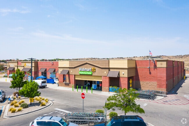
Property Record
8511 Golf Course Rd Nw, Albuquerque, NM 87114


NEARBY LISTINGS FOR SALE OR LEASE
Property Detail
8511 Golf Course Rd Nw
1-012-064-088221-2-09-25
Riverview Parcels Tr H-6A1a-1
Supermarket
TR H-6A1A-1 PLAT OF PARCELS H-6A1A-1 & H-6A1A-2 RIVERVIEW PARCELS CONT 5.1472 AC
AO
Bernalillo
35001C0112G
New Mexico
2024
5.15 AC
2025
West Mesa
004756
Albuquerque
40,160 SF
Albuquerque, NM
DEMOGRAPHICS near 8511 Golf Course Rd Nw
1 Mile
3 Mile
5 Mile
2024 Total Population
8,877
84,330
178,896
2029 Population
8,750
83,538
180,304
Pop Growth 2024-2029
(1.43%)
(0.94%)
+ 0.79%
Average Age
41
40
41
2024 Total Households
3,267
32,766
71,551
HH Growth 2024-2029
(1.68%)
(1.19%)
+ 0.63%
Median Household Inc
$96,904
$88,224
$77,619
Avg Household Size
2.60
2.50
2.40
2024 Avg HH Vehicles
2.00
2.00
2.00
Median Home Value
$280,732
$276,505
$277,734
Median Year Built
1994
1996
1993
Nearby Places
Map Layers
Map Styles
 Street
 Aerial
- Restaurants
- Banks
- Shops
- Fitness
- Groceries
PUBLIC TRANSPORTATION
COMMUTER RAIL
Los Ranchos-Journal Center (Rail Runner Express - New Mexico Rail Runner Express)
DRIVE
WALK
Distance
Los Ranchos-Journal Center (Rail Runner Express - New Mexico Rail Runner Express)
9 min
4.6 mi
Sandia Pueblo (Rail Runner Express - New Mexico Rail Runner Express)
DRIVE
WALK
Distance
Sandia Pueblo (Rail Runner Express - New Mexico Rail Runner Express)
12 min
7.0 mi
AIRPORT
Albuquerque International Sunport
DRIVE
WALK
Distance
Albuquerque International Sunport
38 min
18.7 mi
Nearby Properties
Address
Land Use
TOTAL SIZE
Lot Size
Zoning
Address
Land Use
TOTAL SIZE
Lot Size
Zoning
494,839 SF
37.05 AC
Address
Land Use
TOTAL SIZE
Lot Size
Zoning
63.31 AC
Address
Land Use
TOTAL SIZE
Lot Size
Zoning
212,122 SF
9.99 AC
Address
Land Use
TOTAL SIZE
Lot Size
Zoning
410,793 SF
32.43 AC
Address
Land Use
TOTAL SIZE
Lot Size
Zoning
313,427 SF
45.52 AC
Address
Land Use
TOTAL SIZE
Lot Size
Zoning
221,360 SF
8.78 AC
Address
Land Use
TOTAL SIZE
Lot Size
Zoning
176,140 SF
6.15 AC
Address
Land Use
TOTAL SIZE
Lot Size
Zoning
168,846 SF
7.70 AC
Address
Land Use
TOTAL SIZE
Lot Size
Zoning
171,584 SF
17.28 AC
Address
Land Use
TOTAL SIZE
Lot Size
Zoning
13,548 SF
17.05 AC
Address
Land Use
TOTAL SIZE
Lot Size
Zoning
144,837 SF
15.86 AC
Address
Land Use
TOTAL SIZE
Lot Size
Zoning
Address
Land Use
TOTAL SIZE
Lot Size
Zoning
36,528 SF
13.05 AC
Address
Land Use
TOTAL SIZE
Lot Size
Zoning
106,332 SF
21.64 AC
Address
Land Use
TOTAL SIZE
Lot Size
Zoning
91,368 SF
13.46 AC
Address
Land Use
TOTAL SIZE
Lot Size
Zoning
229,216 SF
20.25 AC
Address
Land Use
TOTAL SIZE
Lot Size
Zoning
45,817 SF
10 AC
Address
Land Use
TOTAL SIZE
Lot Size
Zoning
69,724 SF
7.86 AC
Address
Land Use
TOTAL SIZE
Lot Size
Zoning
25,668 SF
22.52 AC
Address
Land Use
TOTAL SIZE
Lot Size
Zoning
20,854 SF
10.92 AC
Address
Land Use
TOTAL SIZE
Lot Size
Zoning
93,440 SF
12.91 AC
Address
Land Use
TOTAL SIZE
Lot Size
Zoning
125,653 SF
9.72 AC
Address
Land Use
TOTAL SIZE
Lot Size
Zoning
207,228 SF
19.57 AC
Address
Land Use
TOTAL SIZE
Lot Size
Zoning
88.56 AC
Address
Land Use
TOTAL SIZE
Lot Size
Zoning
57,120 SF
13.96 AC
Address
Land Use
TOTAL SIZE
Lot Size
Zoning
84,319 SF
25.98 AC
Address
Land Use
TOTAL SIZE
Lot Size
Zoning
40,318 SF
4.83 AC
Address
Land Use
TOTAL SIZE
Lot Size
Zoning
152,894 SF
14.11 AC
Address
Land Use
TOTAL SIZE
Lot Size
Zoning
7,970 SF
23.68 AC
Address
Land Use
TOTAL SIZE
Lot Size
Zoning
46,183 SF
11.52 AC
The World's #1 Commercial Real Estate Marketplace
Connect with us
© 2026 CoStar Group
The information above has been obtained from sources believed reliable. While we do not doubt its accuracy we have not verified it and make no guarantee, warranty or representation about it. It is your responsibility to independently confirm its accuracy and completeness. Any projections, opinions, assumptions, or estimates used are for example only and do not represent the current or future performance of the property. The value of this transaction to you depends on tax and other factors which should be evaluated by your tax, financial, and legal advisors. You and your advisors should conduct a careful, independent investigation of the property to determine to your satisfaction the suitability of the property for your needs.