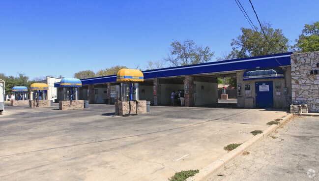
Property Record
8515 Burnet Rd, Austin, TX 78757


NEARBY LISTINGS FOR SALE OR LEASE
Property Detail
8515 Burnet Rd
Austin-Round Rock, TX
Bowling Green
245796
LOT 7-9 BLK B BOWLING GREEN
Restaurantdrivein
Travis
X
Texas
48453C0455J
7-9
2024
0.43 AC
2025
Central
040500
Austin
1,200 SF
DEMOGRAPHICS near 8515 Burnet Rd
1 Mile
3 Mile
5 Mile
2024 Total Population
15,312
145,046
320,662
2029 Population
16,538
157,021
347,208
Pop Growth 2024-2029
+ 8.01%
+ 8.26%
+ 8.28%
Average Age
37
37
38
2024 Total Households
6,785
65,909
145,129
HH Growth 2024-2029
+ 8.93%
+ 9.11%
+ 9.04%
Median Household Inc
$51,505
$67,908
$74,995
Avg Household Size
2.20
2.10
2.10
2024 Avg HH Vehicles
1.00
2.00
2.00
Median Home Value
$456,624
$550,954
$529,514
Median Year Built
1975
1982
1986
Nearby Places
Map Layers
Map Styles
 Street
 Aerial
- Restaurants
- Banks
- Shops
- Fitness
- Groceries
PUBLIC TRANSPORTATION
COMMUTER RAIL
DRIVE
WALK
Distance
16 min
9.2 mi
AIRPORT
Austin-Bergstrom International
DRIVE
WALK
Distance
Austin-Bergstrom International
30 min
19.3 mi
Nearby Properties
Address
Land Use
TOTAL SIZE
Lot Size
Zoning
Address
Land Use
TOTAL SIZE
Lot Size
Zoning
230.30 AC
Address
Land Use
TOTAL SIZE
Lot Size
Zoning
1,234 SF
96.75 AC
Address
Land Use
TOTAL SIZE
Lot Size
Zoning
702,590 SF
48.64 AC
Address
Land Use
TOTAL SIZE
Lot Size
Zoning
1,145,461 SF
34.05 AC
Address
Land Use
TOTAL SIZE
Lot Size
Zoning
371,269 SF
27.63 AC
Address
Land Use
TOTAL SIZE
Lot Size
Zoning
326,626 SF
2.54 AC
Address
Land Use
TOTAL SIZE
Lot Size
Zoning
750,565 SF
65.25 AC
Address
Land Use
TOTAL SIZE
Lot Size
Zoning
320,104 SF
3.27 AC
Address
Land Use
TOTAL SIZE
Lot Size
Zoning
295,320 SF
2.99 AC
Address
Land Use
TOTAL SIZE
Lot Size
Zoning
323,406 SF
2.36 AC
Address
Land Use
TOTAL SIZE
Lot Size
Zoning
571,738 SF
36.06 AC
Address
Land Use
TOTAL SIZE
Lot Size
Zoning
456,682 SF
7.34 AC
Address
Land Use
TOTAL SIZE
Lot Size
Zoning
293,224 SF
4.45 AC
Address
Land Use
TOTAL SIZE
Lot Size
Zoning
480,823 SF
18.46 AC
Address
Land Use
TOTAL SIZE
Lot Size
Zoning
316,888 SF
3.79 AC
Address
Land Use
TOTAL SIZE
Lot Size
Zoning
352,386 SF
33.65 AC
Address
Land Use
TOTAL SIZE
Lot Size
Zoning
354,008 SF
39.99 AC
Address
Land Use
TOTAL SIZE
Lot Size
Zoning
340,785 SF
1.89 AC
Address
Land Use
TOTAL SIZE
Lot Size
Zoning
340,000 SF
1.54 AC
Address
Land Use
TOTAL SIZE
Lot Size
Zoning
300,616 SF
3.95 AC
Address
Land Use
TOTAL SIZE
Lot Size
Zoning
172,307 SF
11.95 AC
Address
Land Use
TOTAL SIZE
Lot Size
Zoning
311,025 SF
4.99 AC
Address
Land Use
TOTAL SIZE
Lot Size
Zoning
233,091 SF
5.61 AC
Address
Land Use
TOTAL SIZE
Lot Size
Zoning
351,012 SF
16.40 AC
Address
Land Use
TOTAL SIZE
Lot Size
Zoning
364,130 SF
42.45 AC
Address
Land Use
TOTAL SIZE
Lot Size
Zoning
314,319 SF
5.97 AC
Address
Land Use
TOTAL SIZE
Lot Size
Zoning
45.78 AC
Address
Land Use
TOTAL SIZE
Lot Size
Zoning
409,082 SF
14.42 AC
Address
Land Use
TOTAL SIZE
Lot Size
Zoning
293,217 SF
22.34 AC
Address
Land Use
TOTAL SIZE
Lot Size
Zoning
286,276 SF
4.53 AC
The World's #1 Commercial Real Estate Marketplace
Connect with us
© 2025 CoStar Group
The information above has been obtained from sources believed reliable. While we do not doubt its accuracy we have not verified it and make no guarantee, warranty or representation about it. It is your responsibility to independently confirm its accuracy and completeness. Any projections, opinions, assumptions, or estimates used are for example only and do not represent the current or future performance of the property. The value of this transaction to you depends on tax and other factors which should be evaluated by your tax, financial, and legal advisors. You and your advisors should conduct a careful, independent investigation of the property to determine to your satisfaction the suitability of the property for your needs.