Property Record
852 E Repplier Rd, Banning, CA 92220


Property Detail
852 E Repplier Rd
Riverside-San Bernardino-Ontario, CA
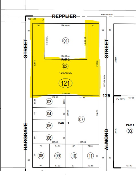
1.29 ACRES M/L IN POR BLK 125 MB 003/149 SD BANNING COLONY LANDS AND POR PAR 2 RS 014/017
534-121-002
RIVERSIDE
Residentialacreage
California
R1
125
B and X Area of moderate flood hazard, usually the area between the limits of the 100-year and 500-year floods.
1.29 AC
2025
Beaumont/Hemet
2025
Inland Empire (California)
044200
NEARBY LISTINGS FOR SALE OR LEASE
DEMOGRAPHICS near 852 E Repplier Rd
1 mile
3 mile
5 mile
2025 Total Population
4,812
20,535
34,841
2030 Population
4,880
21,123
36,234
Pop Growth 2025-2030
+ 1.41%
+ 2.86%
+ 4.00%
Average Age
35
36
41
2025 Total Households
1,369
6,009
11,803
HH Growth 2025-2030
+ 1.10%
+ 2.56%
+ 3.43%
Median Household Inc
$52,152
$63,000
$62,862
Avg Household Size
3.30
3.10
2.80
2025 Avg HH Vehicles
2.00
2.00
2.00
Median Home Value
$333,130
$333,914
$358,479
Median Year Built
1962
1969
1982
Nearby Places
Map Layers
Map Styles
 Street
 Aerial
Layers
 Traffic
 Biking
Places
Listings with unknown addresses are not visible on the map
- Restaurants
- Banks
- Shops
- Fitness
- Groceries
PUBLIC TRANSPORTATION
AIRPORT
Palm Springs International
Drive
Walk
Distance
Palm Springs International
33 min
26.8 mi
Freight Ports
Port of Long Beach
Drive
Walk
Distance
Port of Long Beach
112 min
87.7 mi
SALE & LEASE HISTORY
LISTING DATE
SALE/LEASE

Jun 10, 2022
For Sale
Apr 29, 2025
For Sale
Nearby Properties
Address
Land Use
TOTAL SIZE
Lot Size
Zoning
Address
Land Use
TOTAL SIZE
Lot Size
Zoning
1,000,000 SF
63.69 AC
Address
Land Use
TOTAL SIZE
Lot Size
Zoning
83,989 SF
39.10 AC
M1
Address
Land Use
TOTAL SIZE
Lot Size
Zoning
54,131 SF
3.23 AC
M1
Address
Land Use
TOTAL SIZE
Lot Size
Zoning
82,587 SF
6.78 AC
Address
Land Use
TOTAL SIZE
Lot Size
Zoning
39,250 SF
1.38 AC
C2
Address
Land Use
TOTAL SIZE
Lot Size
Zoning
909 SF
8.17 AC
RA
Address
Land Use
TOTAL SIZE
Lot Size
Zoning
54,455 SF
5.53 AC
R3
Address
Land Use
TOTAL SIZE
Lot Size
Zoning
17,272 SF
1.99 AC
Address
Land Use
TOTAL SIZE
Lot Size
Zoning
119,400 SF
8.21 AC
M
Address
Land Use
TOTAL SIZE
Lot Size
Zoning
50,000 SF
7.13 AC
CM
Address
Land Use
TOTAL SIZE
Lot Size
Zoning
32,520 SF
2.01 AC
Address
Land Use
TOTAL SIZE
Lot Size
Zoning
28,165 SF
2.41 AC
Address
Land Use
TOTAL SIZE
Lot Size
Zoning
102,760 SF
13.29 AC
Address
Land Use
TOTAL SIZE
Lot Size
Zoning
864 SF
4.30 AC
M
Address
Land Use
TOTAL SIZE
Lot Size
Zoning
30,000 SF
2.21 AC
C2
Address
Land Use
TOTAL SIZE
Lot Size
Zoning
29,928 SF
2.98 AC
Address
Land Use
TOTAL SIZE
Lot Size
Zoning
20,304 SF
0.91 AC
RA
Address
Land Use
TOTAL SIZE
Lot Size
Zoning
93,469 SF
7.46 AC
Address
Land Use
TOTAL SIZE
Lot Size
Zoning
15,000 SF
0.99 AC
Address
Land Use
TOTAL SIZE
Lot Size
Zoning
15.29 AC
W2
Address
Land Use
TOTAL SIZE
Lot Size
Zoning
15.25 AC
W2
Address
Land Use
TOTAL SIZE
Lot Size
Zoning
4.57 AC
Address
Land Use
TOTAL SIZE
Lot Size
Zoning
51,600 SF
2.47 AC
M
Address
Land Use
TOTAL SIZE
Lot Size
Zoning
20,000 SF
2.87 AC
Address
Land Use
TOTAL SIZE
Lot Size
Zoning
18,461 SF
1.16 AC
R3
Address
Land Use
TOTAL SIZE
Lot Size
Zoning
70,400 SF
3.18 AC
The World's #1 Commercial Real Estate Marketplace
Connect with us
© 2026 CoStar Group
The information above has been obtained from sources believed reliable. While we do not doubt its accuracy we have not verified it and make no guarantee, warranty or representation about it. It is your responsibility to independently confirm its accuracy and completeness. Any projections, opinions, assumptions, or estimates used are for example only and do not represent the current or future performance of the property. The value of this transaction to you depends on tax and other factors which should be evaluated by your tax, financial, and legal advisors. You and your advisors should conduct a careful, independent investigation of the property to determine to your satisfaction the suitability of the property for your needs.