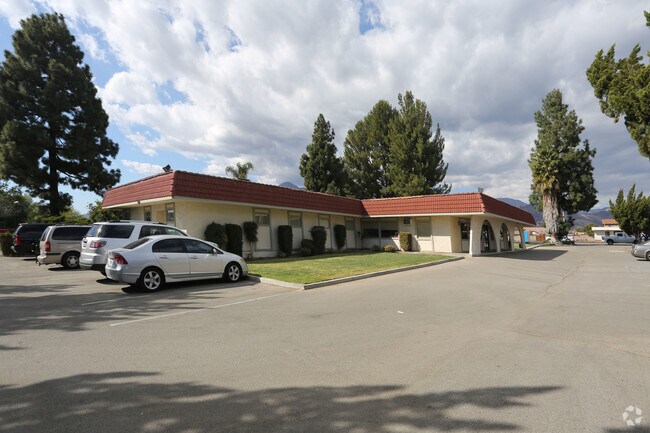
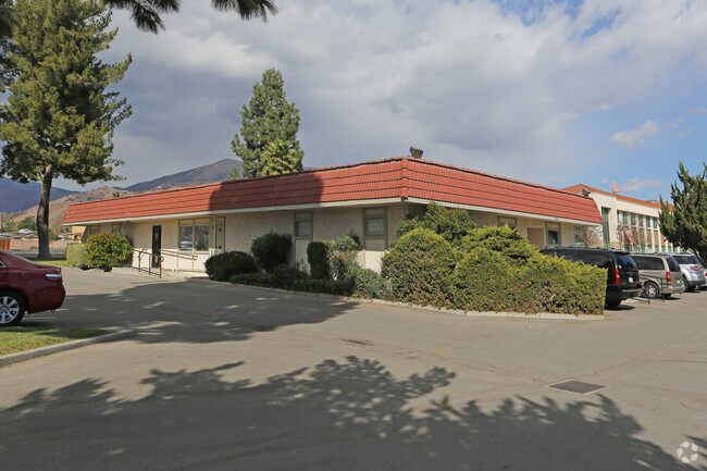
Property Record
852 W Ventura St, Fillmore, CA 93015


Save to a Folder
{{folder.Name}}
{{folder.ListingIds.length}} Properties
{{folder.ListingIds.length}} Property
Create a New Folder
Property Detail
852 W Ventura St
052-0-180-430
MISC 3 PG 5 PART OF LOT 49
Medicalbuilding
VENTURA
C0
California
2025
1.03 AC
2026
Fillmore/NE County
000303
Los Angeles
312 SF
Oxnard-Thousand Oaks-Ventura, CA
NEARBY LISTINGS FOR SALE OR LEASE
-
-
View all Fillmore listings for sale on LoopNet.com
DEMOGRAPHICS near 852 W Ventura St
1 mile
3 mile
5 mile
2025 Total Population
12,661
17,705
17,990
2030 Population
12,542
17,607
17,885
Pop Growth 2025-2030
(0.94%)
(0.55%)
(0.58%)
Average Age
37
38
38
2025 Total Households
3,477
5,024
5,111
HH Growth 2025-2030
(1.01%)
(0.54%)
(0.59%)
Median Household Inc
$88,378
$88,288
$88,244
Avg Household Size
3.60
3.50
3.50
2025 Avg HH Vehicles
2.00
2.00
2.00
Median Home Value
$676,246
$682,097
$684,711
Median Year Built
1973
1974
1974
Nearby Places
Map Layers
Map Styles
 Street
 Aerial
Layers
 Traffic
 Biking
Places
Listings with unknown addresses are not visible on the map
- Restaurants
- Banks
- Shops
- Fitness
- Groceries
PUBLIC TRANSPORTATION
AIRPORT
Bob Hope
Drive
Walk
Distance
Bob Hope
57 min
42.9 mi
Freight Ports
The Port of Hueneme
Drive
Walk
Distance
The Port of Hueneme
42 min
28.2 mi
Nearby Properties
Address
Land Use
TOTAL SIZE
Lot Size
Zoning
Address
Land Use
TOTAL SIZE
Lot Size
Zoning
2.13 AC
Address
Land Use
TOTAL SIZE
Lot Size
Zoning
10.52 AC
AE
Address
Land Use
TOTAL SIZE
Lot Size
Zoning
1.43 AC
RO
Address
Land Use
TOTAL SIZE
Lot Size
Zoning
43,521 SF
0.95 AC
A1
Address
Land Use
TOTAL SIZE
Lot Size
Zoning
1,136 SF
306.33 AC
AEA-E/
Address
Land Use
TOTAL SIZE
Lot Size
Zoning
399.50 AC
AE
Address
Land Use
TOTAL SIZE
Lot Size
Zoning
1.60 AC
Address
Land Use
TOTAL SIZE
Lot Size
Zoning
2.58 AC
A1
Address
Land Use
TOTAL SIZE
Lot Size
Zoning
8,680 SF
2.78 AC
Address
Land Use
TOTAL SIZE
Lot Size
Zoning
39,532 SF
0.37 AC
7
Address
Land Use
TOTAL SIZE
Lot Size
Zoning
1.70 AC
Address
Land Use
TOTAL SIZE
Lot Size
Zoning
25,390 SF
3.32 AC
A1
Address
Land Use
TOTAL SIZE
Lot Size
Zoning
7,380 SF
2.85 AC
M1
Address
Land Use
TOTAL SIZE
Lot Size
Zoning
25,476 SF
3.86 AC
R2PD
Address
Land Use
TOTAL SIZE
Lot Size
Zoning
10.94 AC
Address
Land Use
TOTAL SIZE
Lot Size
Zoning
27,736 SF
1.73 AC
Address
Land Use
TOTAL SIZE
Lot Size
Zoning
16,000 SF
3.22 AC
C3
Address
Land Use
TOTAL SIZE
Lot Size
Zoning
152.03 AC
AE
Address
Land Use
TOTAL SIZE
Lot Size
Zoning
15,546 SF
0.36 AC
C3
Address
Land Use
TOTAL SIZE
Lot Size
Zoning
15,546 SF
0.36 AC
C3
Address
Land Use
TOTAL SIZE
Lot Size
Zoning
15,221 SF
0.35 AC
C3
Address
Land Use
TOTAL SIZE
Lot Size
Zoning
70.89 AC
AE
Address
Land Use
TOTAL SIZE
Lot Size
Zoning
16,730 SF
0.61 AC
R3
Address
Land Use
TOTAL SIZE
Lot Size
Zoning
1,836 SF
0.40 AC
C3
Address
Land Use
TOTAL SIZE
Lot Size
Zoning
71.14 AC
AE/MRP
Address
Land Use
TOTAL SIZE
Lot Size
Zoning
13,703 SF
1.37 AC
RE
Address
Land Use
TOTAL SIZE
Lot Size
Zoning
27.05 AC
AE
Address
Land Use
TOTAL SIZE
Lot Size
Zoning
20,904 SF
1.72 AC
C3
Address
Land Use
TOTAL SIZE
Lot Size
Zoning
0.46 AC
A1
The World's #1 Commercial Real Estate Marketplace
Connect with us
© 2026 CoStar Group
The information above has been obtained from sources believed reliable. While we do not doubt its accuracy we have not verified it and make no guarantee, warranty or representation about it. It is your responsibility to independently confirm its accuracy and completeness. Any projections, opinions, assumptions, or estimates used are for example only and do not represent the current or future performance of the property. The value of this transaction to you depends on tax and other factors which should be evaluated by your tax, financial, and legal advisors. You and your advisors should conduct a careful, independent investigation of the property to determine to your satisfaction the suitability of the property for your needs.