Property Record
8520 Manasota Key Rd, Englewood, FL 34223


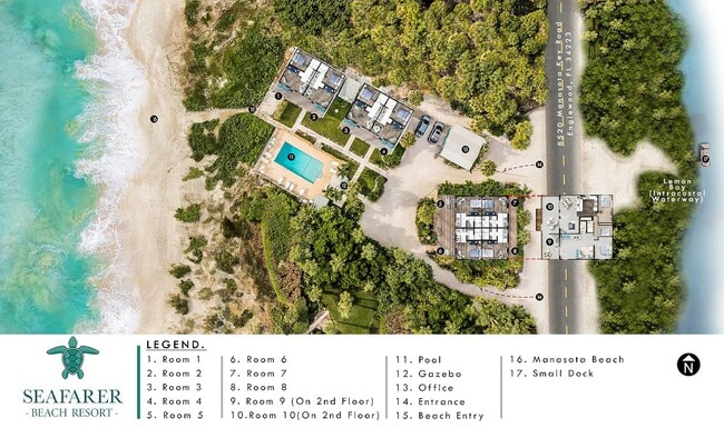
This Property Is For Sale
NEARBY LISTINGS FOR SALE OR LEASE
-
-
View all Englewood listings for sale on LoopNet.com
Property Detail
8520 Manasota Key Rd
North Port-Sarasota-Bradenton, FL
Not Part Of A Subdivision
0476-11-0005
SEAFARER BEACH N 90 FT OF S 1035 FT OF GOVT LOT 5 SEC 9 BEING PARCEL FRONTING 100 FT ON GULF OF MEXICO & RUNNING FROM GULF OF MEXICO TO LEMON BAY & SUBMERGED LAND ADJACENT THERETO IN DB 4 PG 274 &
Hotel
Sarasota
VE
Florida
12115C0343G
5
2024
0.60 AC
2025
Sarasota/Beaches
002601
Tampa/St Petersburg
4,904 SF
DEMOGRAPHICS near 8520 Manasota Key Rd
1 Mile
3 Mile
5 Mile
2024 Total Population
2,142
19,750
54,914
2029 Population
2,513
22,850
63,473
Pop Growth 2024-2029
+ 17.32%
+ 15.70%
+ 15.59%
Average Age
57
56
57
2024 Total Households
1,045
9,543
26,968
HH Growth 2024-2029
+ 17.32%
+ 15.75%
+ 15.69%
Median Household Inc
$72,519
$70,045
$69,987
Avg Household Size
2.00
2.00
2.00
2024 Avg HH Vehicles
2.00
2.00
2.00
Median Home Value
$346,600
$318,146
$314,013
Median Year Built
1985
1987
1987
Nearby Places
Map Layers
Map Styles
 Street
 Aerial
- Restaurants
- Banks
- Shops
- Fitness
- Groceries
PUBLIC TRANSPORTATION
AIRPORT
Sarasota/Bradenton International
DRIVE
WALK
Distance
Sarasota/Bradenton International
54 min
37.7 mi
Punta Gorda
DRIVE
WALK
Distance
Punta Gorda
55 min
41.4 mi
Freight Ports
Port Manatee
DRIVE
WALK
Distance
Port Manatee
66 min
50.2 mi
Nearby Properties
Address
Land Use
TOTAL SIZE
Lot Size
Zoning
Address
Land Use
TOTAL SIZE
Lot Size
Zoning
149,834 SF
36.95 AC
GU
Address
Land Use
TOTAL SIZE
Lot Size
Zoning
159,759 SF
12.60 AC
RMF3
Address
Land Use
TOTAL SIZE
Lot Size
Zoning
201,992 SF
22.45 AC
CG
Address
Land Use
TOTAL SIZE
Lot Size
Zoning
90,484 SF
4.35 AC
CG
Address
Land Use
TOTAL SIZE
Lot Size
Zoning
136.72 AC
OUC
Address
Land Use
TOTAL SIZE
Lot Size
Zoning
4,401 SF
19.27 AC
RMH
Address
Land Use
TOTAL SIZE
Lot Size
Zoning
30,476 SF
3.82 AC
CI
Address
Land Use
TOTAL SIZE
Lot Size
Zoning
77,801 SF
3.16 AC
CG
Address
Land Use
TOTAL SIZE
Lot Size
Zoning
9,519 SF
1.13 AC
RE2
Address
Land Use
TOTAL SIZE
Lot Size
Zoning
4,990 SF
11.86 AC
OUE1
Address
Land Use
TOTAL SIZE
Lot Size
Zoning
18,980 SF
2.71 AC
CI
Address
Land Use
TOTAL SIZE
Lot Size
Zoning
18,800 SF
3.45 AC
CI
Address
Land Use
TOTAL SIZE
Lot Size
Zoning
19,568 SF
1.68 AC
RMF2
Address
Land Use
TOTAL SIZE
Lot Size
Zoning
59,857 SF
2.67 AC
CI
Address
Land Use
TOTAL SIZE
Lot Size
Zoning
20,756 SF
2.91 AC
CI
Address
Land Use
TOTAL SIZE
Lot Size
Zoning
6,059 SF
2.15 AC
CI
Address
Land Use
TOTAL SIZE
Lot Size
Zoning
8,448 SF
1.46 AC
RE2
Address
Land Use
TOTAL SIZE
Lot Size
Zoning
4,226 SF
2.70 AC
RE2
Address
Land Use
TOTAL SIZE
Lot Size
Zoning
2,807 SF
98 AC
GU
Address
Land Use
TOTAL SIZE
Lot Size
Zoning
14,737 SF
2.18 AC
CI
Address
Land Use
TOTAL SIZE
Lot Size
Zoning
5,995 SF
3.01 AC
RE2
Address
Land Use
TOTAL SIZE
Lot Size
Zoning
7,280 SF
0.89 AC
RE2
Address
Land Use
TOTAL SIZE
Lot Size
Zoning
2,444 SF
21.57 AC
GU
Address
Land Use
TOTAL SIZE
Lot Size
Zoning
27,869 SF
6.19 AC
RSF1
Address
Land Use
TOTAL SIZE
Lot Size
Zoning
5,304 SF
1.76 AC
RE2
Address
Land Use
TOTAL SIZE
Lot Size
Zoning
4,411 SF
1.65 AC
RE2
Address
Land Use
TOTAL SIZE
Lot Size
Zoning
2,051 SF
1.91 AC
RE2
Address
Land Use
TOTAL SIZE
Lot Size
Zoning
8,637 SF
1.40 AC
RE2
Address
Land Use
TOTAL SIZE
Lot Size
Zoning
42,234 SF
5.28 AC
RSF3
Address
Land Use
TOTAL SIZE
Lot Size
Zoning
11,200 SF
1.80 AC
CG
The World's #1 Commercial Real Estate Marketplace
Connect with us
© 2026 CoStar Group
The information above has been obtained from sources believed reliable. While we do not doubt its accuracy we have not verified it and make no guarantee, warranty or representation about it. It is your responsibility to independently confirm its accuracy and completeness. Any projections, opinions, assumptions, or estimates used are for example only and do not represent the current or future performance of the property. The value of this transaction to you depends on tax and other factors which should be evaluated by your tax, financial, and legal advisors. You and your advisors should conduct a careful, independent investigation of the property to determine to your satisfaction the suitability of the property for your needs.