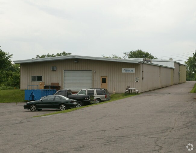
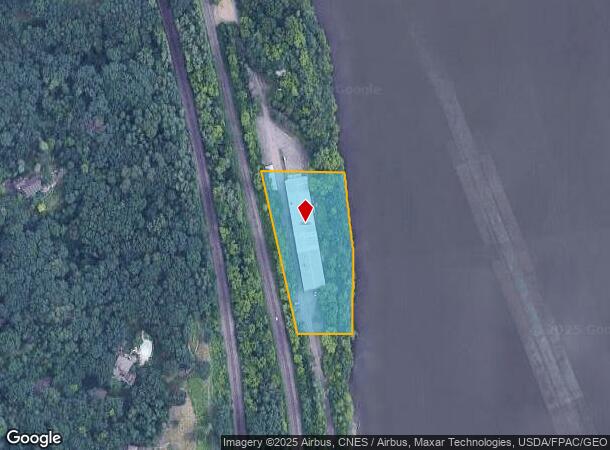
Property Record
8520 River Rd, Inver Grove Heights, MN 55076
NEARBY LISTINGS FOR SALE OR LEASE
Property Detail
8520 River Rd
20-01400-58-020
SECTION 14 TWN 27 RANGE 22 14 27 22 N 450 FT OF GOVT LOT 5 LYING E OF CRI & P RR & W OF MISSISSIPPI RIVER
Industrialgeneral
Dakota
AE
Minnesota
27037C0109E
5
2024
2.06 AC
2024
South Central
060509
Minneapolis/St Paul
22,550 SF
Minneapolis-St. Paul-Bloomington, MN-WI
DEMOGRAPHICS near 8520 River Rd
1 Mile
3 Mile
5 Mile
2024 Total Population
3,410
39,448
99,143
2029 Population
3,510
41,427
104,483
Pop Growth 2024-2029
+ 2.93%
+ 5.02%
+ 5.39%
Average Age
41
40
39
2024 Total Households
1,290
15,182
37,114
HH Growth 2024-2029
+ 2.87%
+ 4.78%
+ 5.16%
Median Household Inc
$104,438
$88,520
$91,897
Avg Household Size
2.60
2.50
2.60
2024 Avg HH Vehicles
2.00
2.00
2.00
Median Home Value
$377,579
$292,828
$301,940
Median Year Built
1994
1987
1984
Nearby Places
Map Layers
Map Styles
 Street
 Aerial
- Restaurants
- Banks
- Shops
- Fitness
- Groceries
PUBLIC TRANSPORTATION
AIRPORT
Minneapolis-St Paul International/Wold-Chamberlain
DRIVE
WALK
Distance
Minneapolis-St Paul International/Wold-Chamberlain
26 min
15.4 mi
Nearby Properties
Address
Land Use
TOTAL SIZE
Lot Size
Zoning
Address
Land Use
TOTAL SIZE
Lot Size
Zoning
238,188 SF
4.86 AC
Address
Land Use
TOTAL SIZE
Lot Size
Zoning
196,078 SF
31.29 AC
Address
Land Use
TOTAL SIZE
Lot Size
Zoning
605,774 SF
44.50 AC
Address
Land Use
TOTAL SIZE
Lot Size
Zoning
794,084 SF
6.97 AC
Address
Land Use
TOTAL SIZE
Lot Size
Zoning
123,968 SF
3.19 AC
Address
Land Use
TOTAL SIZE
Lot Size
Zoning
212,331 SF
9.27 AC
Address
Land Use
TOTAL SIZE
Lot Size
Zoning
169,237 SF
23.38 AC
Address
Land Use
TOTAL SIZE
Lot Size
Zoning
186,856 SF
Address
Land Use
TOTAL SIZE
Lot Size
Zoning
188,997 SF
12.57 AC
Address
Land Use
TOTAL SIZE
Lot Size
Zoning
138,609 SF
3.76 AC
Address
Land Use
TOTAL SIZE
Lot Size
Zoning
41,040 SF
11.38 AC
Address
Land Use
TOTAL SIZE
Lot Size
Zoning
150,469 SF
10.73 AC
Address
Land Use
TOTAL SIZE
Lot Size
Zoning
28,461 SF
16.13 AC
Address
Land Use
TOTAL SIZE
Lot Size
Zoning
97,340 SF
9.80 AC
Address
Land Use
TOTAL SIZE
Lot Size
Zoning
168,235 SF
20.12 AC
Address
Land Use
TOTAL SIZE
Lot Size
Zoning
117,356 SF
2.96 AC
Address
Land Use
TOTAL SIZE
Lot Size
Zoning
95,872 SF
9.61 AC
Address
Land Use
TOTAL SIZE
Lot Size
Zoning
143,712 SF
9.57 AC
Address
Land Use
TOTAL SIZE
Lot Size
Zoning
97,792 SF
16.39 AC
Address
Land Use
TOTAL SIZE
Lot Size
Zoning
161,676 SF
13.90 AC
Address
Land Use
TOTAL SIZE
Lot Size
Zoning
95,693 SF
3.64 AC
Address
Land Use
TOTAL SIZE
Lot Size
Zoning
48,168 SF
6.45 AC
Address
Land Use
TOTAL SIZE
Lot Size
Zoning
135,084 SF
7.23 AC
Address
Land Use
TOTAL SIZE
Lot Size
Zoning
72,350 SF
1.86 AC
Address
Land Use
TOTAL SIZE
Lot Size
Zoning
96,000 SF
6.41 AC
Address
Land Use
TOTAL SIZE
Lot Size
Zoning
76,452 SF
13.76 AC
Address
Land Use
TOTAL SIZE
Lot Size
Zoning
83,000 SF
6.45 AC
Address
Land Use
TOTAL SIZE
Lot Size
Zoning
35,396 SF
2.02 AC
Address
Land Use
TOTAL SIZE
Lot Size
Zoning
85,104 SF
11.75 AC
Address
Land Use
TOTAL SIZE
Lot Size
Zoning
61,138 SF
7.67 AC
The World's #1 Commercial Real Estate Marketplace
Connect with us
© 2025 CoStar Group
The information above has been obtained from sources believed reliable. While we do not doubt its accuracy we have not verified it and make no guarantee, warranty or representation about it. It is your responsibility to independently confirm its accuracy and completeness. Any projections, opinions, assumptions, or estimates used are for example only and do not represent the current or future performance of the property. The value of this transaction to you depends on tax and other factors which should be evaluated by your tax, financial, and legal advisors. You and your advisors should conduct a careful, independent investigation of the property to determine to your satisfaction the suitability of the property for your needs.