Property Record
8524 Navarre Pky, Navarre, FL 32566

NEARBY LISTINGS FOR SALE OR LEASE
-
-
View all Navarre listings for sale on LoopNet.com
Property Detail
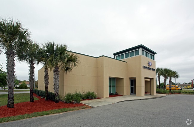
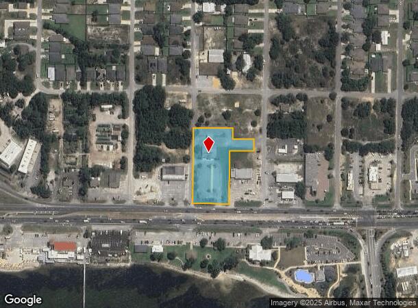
8524 Navarre Pky
Pensacola-Ferry Pass-Brent, FL
Navarre
21-2S-26-2710-00700-0060
(*DESC PER DEED FOR 2012:) NAVARRE SUB LOTS 5 6 8 10 12 14 & N 80 FT OF LOTS 16 & 18 BLK 7 & VAC ALLEY LYING BTWN SAID LOTS AS VAC IN OR 389 PG 795 LESS PORTIONS OF LOTS 5 6 7 & VAC ALLEY WITHIN TH FOLL: BEG AT NE CORN LOT 1 BLK 7 THN S00*0152E ON W
Financialbuilding
Santa Rosa
X
Florida
12113C0588H
6
2024
1.74 AC
2025
Navarre
010827
Pensacola
6,486 SF
DEMOGRAPHICS near 8524 Navarre Pky
1 Mile
3 Mile
5 Mile
2024 Total Population
5,176
27,593
48,217
2029 Population
5,944
32,057
55,592
Pop Growth 2024-2029
+ 14.84%
+ 16.18%
+ 15.30%
Average Age
37
39
40
2024 Total Households
1,877
10,623
18,212
HH Growth 2024-2029
+ 15.18%
+ 16.85%
+ 15.86%
Median Household Inc
$89,896
$93,749
$95,529
Avg Household Size
2.70
2.60
2.60
2024 Avg HH Vehicles
2.00
2.00
2.00
Median Home Value
$288,197
$302,076
$310,186
Median Year Built
2001
1999
2000
Nearby Places
Map Layers
Map Styles
 Street
 Aerial
- Restaurants
- Banks
- Shops
- Fitness
- Groceries
PUBLIC TRANSPORTATION
AIRPORT
Eglin AFB/Destin-Ft Walton Beach
DRIVE
WALK
Distance
Eglin AFB/Destin-Ft Walton Beach
52 min
26.5 mi
Pensacola International
DRIVE
WALK
Distance
Pensacola International
52 min
29.5 mi
Nearby Properties
Address
Land Use
TOTAL SIZE
Lot Size
Zoning
Address
Land Use
TOTAL SIZE
Lot Size
Zoning
44,985 SF
317.38 AC
NB-C
Address
Land Use
TOTAL SIZE
Lot Size
Zoning
344,974 SF
16.11 AC
R3
Address
Land Use
TOTAL SIZE
Lot Size
Zoning
375,552 SF
10.62 AC
PBD
Address
Land Use
TOTAL SIZE
Lot Size
Zoning
131,381 SF
8.84 AC
HNB
Address
Land Use
TOTAL SIZE
Lot Size
Zoning
244,004 SF
10.54 AC
HCD
Address
Land Use
TOTAL SIZE
Lot Size
Zoning
110,921 SF
9.65 AC
HCD
Address
Land Use
TOTAL SIZE
Lot Size
Zoning
131,381 SF
11.25 AC
HNB
Address
Land Use
TOTAL SIZE
Lot Size
Zoning
23.12 AC
C
Address
Land Use
TOTAL SIZE
Lot Size
Zoning
248,857 SF
22.80 AC
PBD
Address
Land Use
TOTAL SIZE
Lot Size
Zoning
106,696 SF
15.59 AC
HCD
Address
Land Use
TOTAL SIZE
Lot Size
Zoning
7,800 SF
7.68 AC
R2
Address
Land Use
TOTAL SIZE
Lot Size
Zoning
77,417 SF
8.06 AC
HCD
Address
Land Use
TOTAL SIZE
Lot Size
Zoning
97,214 SF
2.79 AC
HCD
Address
Land Use
TOTAL SIZE
Lot Size
Zoning
65,936 SF
1.86 AC
PBD
Address
Land Use
TOTAL SIZE
Lot Size
Zoning
68,334 SF
4.45 AC
HCD
Address
Land Use
TOTAL SIZE
Lot Size
Zoning
48,055 SF
9.12 AC
HCD
Address
Land Use
TOTAL SIZE
Lot Size
Zoning
60,854 SF
7.07 AC
HCD
Address
Land Use
TOTAL SIZE
Lot Size
Zoning
14,448 SF
17.20 AC
P
Address
Land Use
TOTAL SIZE
Lot Size
Zoning
48,198 SF
1.76 AC
PBD
Address
Land Use
TOTAL SIZE
Lot Size
Zoning
21,567 SF
5.56 AC
HCD
Address
Land Use
TOTAL SIZE
Lot Size
Zoning
4,975 SF
6.03 AC
HCD
Address
Land Use
TOTAL SIZE
Lot Size
Zoning
8,714 SF
7 AC
P2-HON
Address
Land Use
TOTAL SIZE
Lot Size
Zoning
45,672 SF
2.47 AC
PUD
Address
Land Use
TOTAL SIZE
Lot Size
Zoning
2,046 SF
0.79 AC
HCD
Address
Land Use
TOTAL SIZE
Lot Size
Zoning
3.39 AC
NB-C
Address
Land Use
TOTAL SIZE
Lot Size
Zoning
37,436 SF
4.79 AC
R3
Address
Land Use
TOTAL SIZE
Lot Size
Zoning
14,208 SF
4.53 AC
HCD
Address
Land Use
TOTAL SIZE
Lot Size
Zoning
36,749 SF
2.75 AC
HCD
Address
Land Use
TOTAL SIZE
Lot Size
Zoning
26,192 SF
3.82 AC
HCD
The World's #1 Commercial Real Estate Marketplace
Connect with us
© 2025 CoStar Group
The information above has been obtained from sources believed reliable. While we do not doubt its accuracy we have not verified it and make no guarantee, warranty or representation about it. It is your responsibility to independently confirm its accuracy and completeness. Any projections, opinions, assumptions, or estimates used are for example only and do not represent the current or future performance of the property. The value of this transaction to you depends on tax and other factors which should be evaluated by your tax, financial, and legal advisors. You and your advisors should conduct a careful, independent investigation of the property to determine to your satisfaction the suitability of the property for your needs.