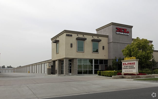
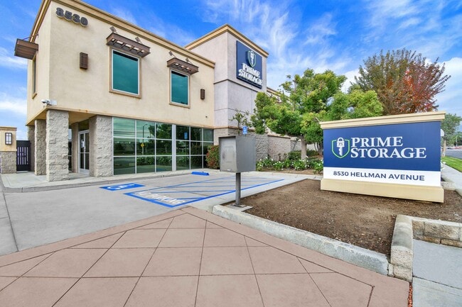
Property Record
8530 Hellman Ave, Rancho Cucamonga, CA 91730

Current Lease Availabilities
Property Detail
8530 Hellman Ave
0209-012-07
PARCEL MAP 1802 PARCEL 4
Publicstorage
San Bernardino
B and X Area of moderate flood hazard, usually the area between the limits of the 100-year and 500-year floods.
California
2025
4.95 AC
2025
Airport Area
002105
Inland Empire (California)
125,716 SF
Riverside-San Bernardino-Ontario, CA
NEARBY LISTINGS FOR SALE OR LEASE
DEMOGRAPHICS near 8530 Hellman Ave
1 mile
3 mile
5 mile
2025 Total Population
19,242
168,643
347,969
2030 Population
19,320
170,088
350,176
Pop Growth 2025-2030
+ 0.41%
+ 0.86%
+ 0.63%
Average Age
39
38
38
2025 Total Households
6,616
56,798
113,626
HH Growth 2025-2030
+ 0.35%
+ 0.94%
+ 0.69%
Median Household Inc
$92,245
$91,603
$98,376
Avg Household Size
2.80
2.90
3.00
2025 Avg HH Vehicles
2.00
2.00
2.00
Median Home Value
$641,063
$675,528
$716,115
Median Year Built
1978
1982
1981
Nearby Places
Map Layers
Map Styles
 Street
 Aerial
Layers
 Traffic
 Biking
Places
Listings with unknown addresses are not visible on the map
- Restaurants
- Banks
- Shops
- Fitness
- Groceries
PUBLIC TRANSPORTATION
COMMUTER RAIL
Upland (San Bernardino Line - Southern California Regional Rail Authority (Metrolink))
Drive
Walk
Distance
Upland (San Bernardino Line - Southern California Regional Rail Authority (Metrolink))
6 min
2.9 mi
Rancho Cucamonga (San Bernardino Line - Southern California Regional Rail Authority (Metrolink))
Drive
Walk
Distance
Rancho Cucamonga (San Bernardino Line - Southern California Regional Rail Authority (Metrolink))
7 min
3.7 mi
AIRPORT
Ontario International
Drive
Walk
Distance
Ontario International
8 min
3.9 mi
Freight Ports
Port of Long Beach
Drive
Walk
Distance
Port of Long Beach
68 min
54.3 mi
Nearby Properties
Address
Land Use
TOTAL SIZE
Lot Size
Zoning
Address
Land Use
TOTAL SIZE
Lot Size
Zoning
376,610 SF
25.22 AC
Address
Land Use
TOTAL SIZE
Lot Size
Zoning
244,370 SF
59.72 AC
Address
Land Use
TOTAL SIZE
Lot Size
Zoning
707,551 SF
20.36 AC
Address
Land Use
TOTAL SIZE
Lot Size
Zoning
539,128 SF
10.24 AC
Address
Land Use
TOTAL SIZE
Lot Size
Zoning
293,860 SF
16.10 AC
Address
Land Use
TOTAL SIZE
Lot Size
Zoning
545,161 SF
11.10 AC
Address
Land Use
TOTAL SIZE
Lot Size
Zoning
453,960 SF
18.54 AC
Address
Land Use
TOTAL SIZE
Lot Size
Zoning
591,495 SF
18.29 AC
Address
Land Use
TOTAL SIZE
Lot Size
Zoning
1,052,840 SF
41.85 AC
Address
Land Use
TOTAL SIZE
Lot Size
Zoning
531,988 SF
9.83 AC
Address
Land Use
TOTAL SIZE
Lot Size
Zoning
286,732 SF
9.58 AC
Address
Land Use
TOTAL SIZE
Lot Size
Zoning
261,357 SF
10.03 AC
Address
Land Use
TOTAL SIZE
Lot Size
Zoning
440,209 SF
10.34 AC
Address
Land Use
TOTAL SIZE
Lot Size
Zoning
830,300 SF
39.99 AC
Address
Land Use
TOTAL SIZE
Lot Size
Zoning
190,724 SF
10.69 AC
Address
Land Use
TOTAL SIZE
Lot Size
Zoning
387,965 SF
10.92 AC
Address
Land Use
TOTAL SIZE
Lot Size
Zoning
468,682 SF
19.40 AC
Address
Land Use
TOTAL SIZE
Lot Size
Zoning
174,092 SF
4.42 AC
Address
Land Use
TOTAL SIZE
Lot Size
Zoning
358,375 SF
9.30 AC
Address
Land Use
TOTAL SIZE
Lot Size
Zoning
183,039 SF
8.30 AC
Address
Land Use
TOTAL SIZE
Lot Size
Zoning
246,012 SF
5.97 AC
Address
Land Use
TOTAL SIZE
Lot Size
Zoning
314,559 SF
9.34 AC
Address
Land Use
TOTAL SIZE
Lot Size
Zoning
251,645 SF
4.50 AC
Address
Land Use
TOTAL SIZE
Lot Size
Zoning
573,220 SF
32.33 AC
Address
Land Use
TOTAL SIZE
Lot Size
Zoning
780,648 SF
13.59 AC
Address
Land Use
TOTAL SIZE
Lot Size
Zoning
303,915 SF
11.13 AC
Address
Land Use
TOTAL SIZE
Lot Size
Zoning
553,882 SF
24.59 AC
Address
Land Use
TOTAL SIZE
Lot Size
Zoning
401,226 SF
17.62 AC
Address
Land Use
TOTAL SIZE
Lot Size
Zoning
175,291 SF
9.44 AC
Address
Land Use
TOTAL SIZE
Lot Size
Zoning
502,917 SF
35.94 AC
The World's #1 Commercial Real Estate Marketplace
Connect with us
© 2026 CoStar Group
The information above has been obtained from sources believed reliable. While we do not doubt its accuracy we have not verified it and make no guarantee, warranty or representation about it. It is your responsibility to independently confirm its accuracy and completeness. Any projections, opinions, assumptions, or estimates used are for example only and do not represent the current or future performance of the property. The value of this transaction to you depends on tax and other factors which should be evaluated by your tax, financial, and legal advisors. You and your advisors should conduct a careful, independent investigation of the property to determine to your satisfaction the suitability of the property for your needs.