Property Record
8530 Highway 31 N, Morris, AL 35116


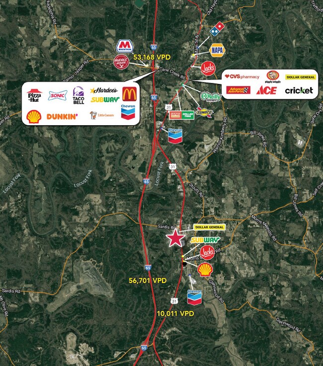
NEARBY LISTINGS FOR SALE OR LEASE
-
-
View all Morris listings for lease on LoopNet.com
Property Detail
8530 Highway 31 N
Birmingham
Amended Map Rock Solid-Rap Pro
Birmingham-Hoover, AL
LOT 3 ROCK SOLID-RAP PROPERTIES SUR 260/14 AMENDED MAP 260/68
07-00-02-4-000-018.002
Jefferson
Storebuilding
Alabama
0
3
2024
1.46 AC
011304
Fultondale
6,500 SF
DEMOGRAPHICS near 8530 Highway 31 N
1 Mile
3 Mile
5 Mile
2024 Total Population
1,788
7,611
15,611
2029 Population
1,794
7,632
15,571
Pop Growth 2024-2029
+ 0.34%
+ 0.28%
(0.26%)
Average Age
39
40
40
2024 Total Households
673
2,881
6,037
HH Growth 2024-2029
+ 0.30%
+ 0.28%
(0.25%)
Median Household Inc
$94,380
$87,996
$80,413
Avg Household Size
2.70
2.60
2.60
2024 Avg HH Vehicles
2.00
2.00
2.00
Median Home Value
$320,380
$310,235
$272,938
Median Year Built
1998
1997
1993
Nearby Places
Map Layers
Map Styles
 Street
 Aerial
- Restaurants
- Banks
- Shops
- Fitness
- Groceries
PUBLIC TRANSPORTATION
AIRPORT
Birmingham-Shuttlesworth International
DRIVE
WALK
Distance
Birmingham-Shuttlesworth International
31 min
23.9 mi
Freight Ports
Port of Mobile
DRIVE
WALK
Distance
Port of Mobile
300 min
273.7 mi
SALE & LEASE HISTORY
LISTING DATE
SALE/LEASE

Jan 25, 2024
For Lease
Nearby Properties
Address
Land Use
TOTAL SIZE
Lot Size
Zoning
Address
Land Use
TOTAL SIZE
Lot Size
Zoning
59,133 SF
5.80 AC
INST
Address
Land Use
TOTAL SIZE
Lot Size
Zoning
31,148 SF
46 AC
B
Address
Land Use
TOTAL SIZE
Lot Size
Zoning
6,370 SF
4.14 AC
B3
Address
Land Use
TOTAL SIZE
Lot Size
Zoning
74,400 SF
7 AC
I35
Address
Land Use
TOTAL SIZE
Lot Size
Zoning
34,552 SF
2.53 AC
I1
Address
Land Use
TOTAL SIZE
Lot Size
Zoning
6,509 SF
4.09 AC
B
Address
Land Use
TOTAL SIZE
Lot Size
Zoning
41,296 SF
2.12 AC
B
Address
Land Use
TOTAL SIZE
Lot Size
Zoning
10,920 SF
0.87 AC
C2
Address
Land Use
TOTAL SIZE
Lot Size
Zoning
12,900 SF
3.19 AC
Address
Land Use
TOTAL SIZE
Lot Size
Zoning
3,214 SF
0.89 AC
C2
Address
Land Use
TOTAL SIZE
Lot Size
Zoning
10,598 SF
2.18 AC
A1
Address
Land Use
TOTAL SIZE
Lot Size
Zoning
18,957 SF
6.20 AC
INST
Address
Land Use
TOTAL SIZE
Lot Size
Zoning
18,900 SF
3.50 AC
B
Address
Land Use
TOTAL SIZE
Lot Size
Zoning
3,240 SF
0.62 AC
C2
Address
Land Use
TOTAL SIZE
Lot Size
Zoning
1,008 SF
30 AC
C2
Address
Land Use
TOTAL SIZE
Lot Size
Zoning
4,965 SF
4.83 AC
B
Address
Land Use
TOTAL SIZE
Lot Size
Zoning
2,400 SF
0.93 AC
B
Address
Land Use
TOTAL SIZE
Lot Size
Zoning
10,600 SF
0.85 AC
NONE
Address
Land Use
TOTAL SIZE
Lot Size
Zoning
9,024 SF
1.05 AC
I3
Address
Land Use
TOTAL SIZE
Lot Size
Zoning
46,966 SF
5.20 AC
LI
Address
Land Use
TOTAL SIZE
Lot Size
Zoning
9,090 SF
1.14 AC
A1
Address
Land Use
TOTAL SIZE
Lot Size
Zoning
8,080 SF
2 AC
NONE
Address
Land Use
TOTAL SIZE
Lot Size
Zoning
7,970 SF
4.14 AC
C1
Address
Land Use
TOTAL SIZE
Lot Size
Zoning
9,964 SF
1.40 AC
NONE
Address
Land Use
TOTAL SIZE
Lot Size
Zoning
8,006 SF
0.73 AC
I3
Address
Land Use
TOTAL SIZE
Lot Size
Zoning
6,435 SF
0.38 AC
B1
Address
Land Use
TOTAL SIZE
Lot Size
Zoning
7,800 SF
1.50 AC
I35
Address
Land Use
TOTAL SIZE
Lot Size
Zoning
10,169 SF
4.80 AC
INST
The World's #1 Commercial Real Estate Marketplace
Connect with us
© 2026 CoStar Group
The information above has been obtained from sources believed reliable. While we do not doubt its accuracy we have not verified it and make no guarantee, warranty or representation about it. It is your responsibility to independently confirm its accuracy and completeness. Any projections, opinions, assumptions, or estimates used are for example only and do not represent the current or future performance of the property. The value of this transaction to you depends on tax and other factors which should be evaluated by your tax, financial, and legal advisors. You and your advisors should conduct a careful, independent investigation of the property to determine to your satisfaction the suitability of the property for your needs.