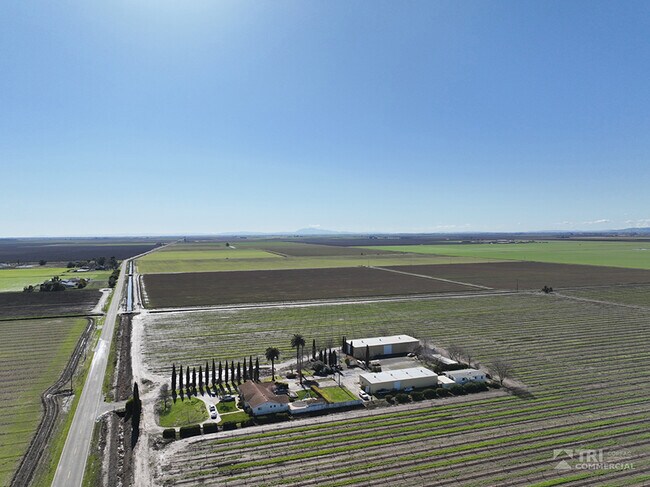
Property Record
8535 Bulkley Rd, Dixon, CA 95620

Property Detail
8535 Bulkley Rd
Vallejo, CA
BK-BG 00-00
0111-070-020
SOLANO
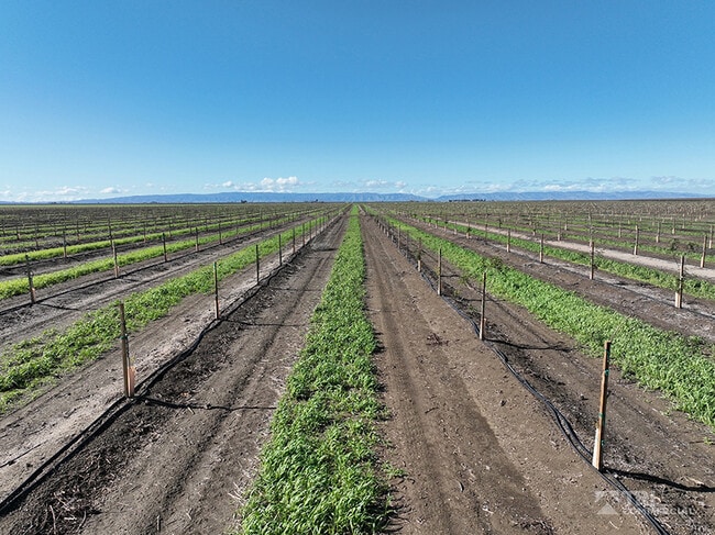
Farms
California
B and X Area of moderate flood hazard, usually the area between the limits of the 100-year and 500-year floods.
146.33 AC
2024
Outer Solano County
2025
North Bay/Santa Rosa
253300
NEARBY LISTINGS FOR SALE OR LEASE
-
-
View all Dixon listings for sale on LoopNet.com
DEMOGRAPHICS near 8535 Bulkley Rd
1 mile
3 mile
5 mile
2025 Total Population
52
181
39,893
2030 Population
49
170
41,125
Pop Growth 2025-2030
(5.77%)
(6.08%)
+ 3.09%
Average Age
42
44
31
2025 Total Households
19
64
12,411
HH Growth 2025-2030
(5.26%)
(4.69%)
+ 2.93%
Median Household Inc
$87,500
$91,071
$70,566
Avg Household Size
3.00
2.80
2.40
2025 Avg HH Vehicles
3.00
3.00
2.00
Median Home Value
$999,999
$1,018,750
$844,910
Median Year Built
1969
1970
1985
Nearby Places
Map Layers
Map Styles
 Street
 Aerial
Transit
 Traffic
 Biking
Places
Listings with unknown addresses are not visible on the map
- Restaurants
- Banks
- Shops
- Fitness
- Groceries
PUBLIC TRANSPORTATION
COMMUTER RAIL
Davis (Capitol Corridor - Capitol Corridor Joint Powers Authority)
Drive
Walk
Distance
Davis (Capitol Corridor - Capitol Corridor Joint Powers Authority)
16 min
7.5 mi
AIRPORT
Sacramento International
Drive
Walk
Distance
Sacramento International
42 min
25.8 mi
Freight Ports
Port of Stockton
Drive
Walk
Distance
Port of Stockton
79 min
61.8 mi
SALE & LEASE HISTORY
LISTING DATE
SALE/LEASE

Feb 12, 2025
For Sale
Dec 09, 2021
For Sale
Nearby Properties
Address
Land Use
TOTAL SIZE
Lot Size
Zoning
Address
Land Use
TOTAL SIZE
Lot Size
Zoning
240 AC
A1
Address
Land Use
TOTAL SIZE
Lot Size
Zoning
158.18 AC
A-40
Address
Land Use
TOTAL SIZE
Lot Size
Zoning
10 AC
AP
Address
Land Use
TOTAL SIZE
Lot Size
Zoning
41.56 AC
Address
Land Use
TOTAL SIZE
Lot Size
Zoning
79.12 AC
Address
Land Use
TOTAL SIZE
Lot Size
Zoning
2,029 SF
156.97 AC
Address
Land Use
TOTAL SIZE
Lot Size
Zoning
158.79 AC
Address
Land Use
TOTAL SIZE
Lot Size
Zoning
2,758 SF
46.47 AC
Address
Land Use
TOTAL SIZE
Lot Size
Zoning
2,986 SF
150.20 AC
A-40
Address
Land Use
TOTAL SIZE
Lot Size
Zoning
3,111 SF
68.72 AC
Address
Land Use
TOTAL SIZE
Lot Size
Zoning
159.86 AC
A 40
Address
Land Use
TOTAL SIZE
Lot Size
Zoning
1,735 SF
69.34 AC
Address
Land Use
TOTAL SIZE
Lot Size
Zoning
158.18 AC
Address
Land Use
TOTAL SIZE
Lot Size
Zoning
160 AC
Address
Land Use
TOTAL SIZE
Lot Size
Zoning
564.01 AC
Address
Land Use
TOTAL SIZE
Lot Size
Zoning
160 AC
AP
Address
Land Use
TOTAL SIZE
Lot Size
Zoning
43.44 AC
Address
Land Use
TOTAL SIZE
Lot Size
Zoning
127.52 AC
Address
Land Use
TOTAL SIZE
Lot Size
Zoning
158 AC
A1
Address
Land Use
TOTAL SIZE
Lot Size
Zoning
3,402 SF
46.18 AC
A-40
Address
Land Use
TOTAL SIZE
Lot Size
Zoning
77.30 AC
Address
Land Use
TOTAL SIZE
Lot Size
Zoning
270.50 AC
Address
Land Use
TOTAL SIZE
Lot Size
Zoning
156.38 AC
A40
Address
Land Use
TOTAL SIZE
Lot Size
Zoning
2,503 SF
80 AC
A1
Address
Land Use
TOTAL SIZE
Lot Size
Zoning
45.47 AC
A-40
Address
Land Use
TOTAL SIZE
Lot Size
Zoning
312.71 AC
Address
Land Use
TOTAL SIZE
Lot Size
Zoning
155.12 AC
A 40
Address
Land Use
TOTAL SIZE
Lot Size
Zoning
2,791 SF
126.93 AC
Address
Land Use
TOTAL SIZE
Lot Size
Zoning
15.63 AC
The World's #1 Commercial Real Estate Marketplace
Connect with us
© 2026 CoStar Group
The information above has been obtained from sources believed reliable. While we do not doubt its accuracy we have not verified it and make no guarantee, warranty or representation about it. It is your responsibility to independently confirm its accuracy and completeness. Any projections, opinions, assumptions, or estimates used are for example only and do not represent the current or future performance of the property. The value of this transaction to you depends on tax and other factors which should be evaluated by your tax, financial, and legal advisors. You and your advisors should conduct a careful, independent investigation of the property to determine to your satisfaction the suitability of the property for your needs.