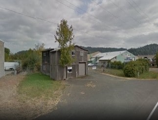
Property Record
85386 Highway 99 S, Eugene, OR 97405

Property Detail
85386 Highway 99 S
Eugene-Springfield, OR
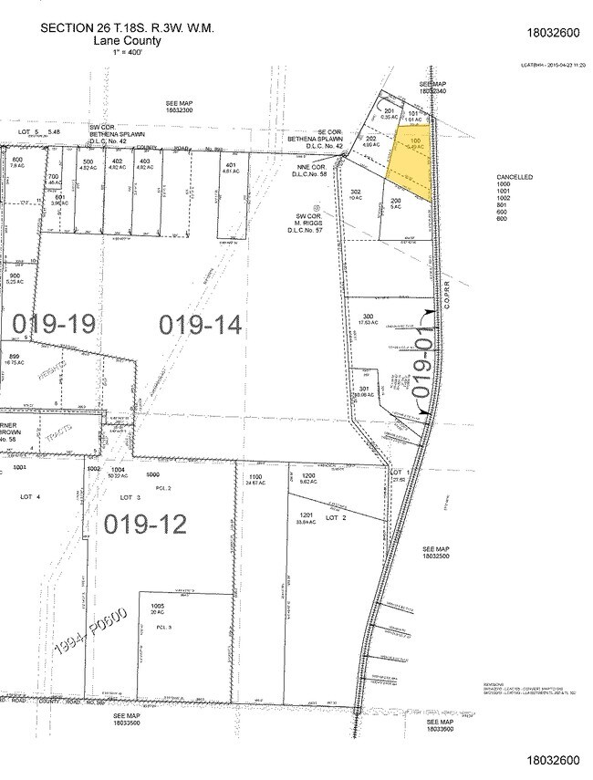
TL 00100
0690816
Lane
Industrialgeneral
Oregon
E25
100
B and X Area of moderate flood hazard, usually the area between the limits of the 100-year and 500-year floods.
5.49 AC
2025
Lane County
2025
Portland
001700
NEARBY LISTINGS FOR SALE OR LEASE
-
-
View all Eugene listings for sale on LoopNet.com
DEMOGRAPHICS near 85386 Highway 99 S
1 mile
3 mile
5 mile
2025 Total Population
364
3,088
53,593
2030 Population
358
3,031
53,319
Pop Growth 2025-2030
(1.65%)
(1.85%)
(0.51%)
Average Age
43
45
41
2025 Total Households
132
1,195
21,757
HH Growth 2025-2030
(2.27%)
(1.92%)
(0.60%)
Median Household Inc
$137,740
$114,594
$84,362
Avg Household Size
2.70
2.50
2.40
2025 Avg HH Vehicles
2.00
2.00
2.00
Median Home Value
$940,789
$686,926
$480,733
Median Year Built
1972
1970
1973
Nearby Places
Map Layers
Map Styles
 Street
 Aerial
Transit
 Traffic
 Biking
Places
Listings with unknown addresses are not visible on the map
- Restaurants
- Banks
- Shops
- Fitness
- Groceries
PUBLIC TRANSPORTATION
COMMUTER RAIL
Eugene (Amtrak Cascades - Amtrak, Coast Starlight - Amtrak)
Drive
Walk
Distance
Eugene (Amtrak Cascades - Amtrak, Coast Starlight - Amtrak)
14 min
7.8 mi
AIRPORT
Mahlon Sweet Field
Drive
Walk
Distance
Mahlon Sweet Field
29 min
17.9 mi
Freight Ports
Port of Coos Bay, OR
Drive
Walk
Distance
Port of Coos Bay, OR
158 min
108.6 mi
Nearby Properties
Address
Land Use
TOTAL SIZE
Lot Size
Zoning
Address
Land Use
TOTAL SIZE
Lot Size
Zoning
121.46 AC
E25
Address
Land Use
TOTAL SIZE
Lot Size
Zoning
Address
Land Use
TOTAL SIZE
Lot Size
Zoning
5.62 AC
RI
Address
Land Use
TOTAL SIZE
Lot Size
Zoning
5 AC
E25
Address
Land Use
TOTAL SIZE
Lot Size
Zoning
Address
Land Use
TOTAL SIZE
Lot Size
Zoning
5.60 AC
RI
Address
Land Use
TOTAL SIZE
Lot Size
Zoning
2.41 AC
C2
Address
Land Use
TOTAL SIZE
Lot Size
Zoning
8.20 AC
RPF
Address
Land Use
TOTAL SIZE
Lot Size
Zoning
1,120 SF
5.07 AC
C2
Address
Land Use
TOTAL SIZE
Lot Size
Zoning
1,540 SF
2.54 AC
RI
Address
Land Use
TOTAL SIZE
Lot Size
Zoning
5.45 AC
RI
Address
Land Use
TOTAL SIZE
Lot Size
Zoning
80.43 AC
RR5
Address
Land Use
TOTAL SIZE
Lot Size
Zoning
10,368 SF
2.07 AC
RI
Address
Land Use
TOTAL SIZE
Lot Size
Zoning
1.83 AC
RI
Address
Land Use
TOTAL SIZE
Lot Size
Zoning
3.46 AC
RI
Address
Land Use
TOTAL SIZE
Lot Size
Zoning
0.65 AC
C2
Address
Land Use
TOTAL SIZE
Lot Size
Zoning
1.94 AC
RI
Address
Land Use
TOTAL SIZE
Lot Size
Zoning
2.63 AC
RC
Address
Land Use
TOTAL SIZE
Lot Size
Zoning
2.43 AC
C2
Address
Land Use
TOTAL SIZE
Lot Size
Zoning
5,908 SF
34.89 AC
E25
Address
Land Use
TOTAL SIZE
Lot Size
Zoning
300 SF
372.09 AC
E25
Address
Land Use
TOTAL SIZE
Lot Size
Zoning
1,640 SF
9.50 AC
E25
Address
Land Use
TOTAL SIZE
Lot Size
Zoning
115.47 AC
E25
Address
Land Use
TOTAL SIZE
Lot Size
Zoning
8.43 AC
E40
Address
Land Use
TOTAL SIZE
Lot Size
Zoning
2.36 AC
RI
Address
Land Use
TOTAL SIZE
Lot Size
Zoning
1.50 AC
RI
Address
Land Use
TOTAL SIZE
Lot Size
Zoning
2.26 AC
RI
Address
Land Use
TOTAL SIZE
Lot Size
Zoning
4.33 AC
RR5
Address
Land Use
TOTAL SIZE
Lot Size
Zoning
5,086 SF
30 AC
E30
Address
Land Use
TOTAL SIZE
Lot Size
Zoning
0.29 AC
RR2
The World's #1 Commercial Real Estate Marketplace
Connect with us
© 2026 CoStar Group
The information above has been obtained from sources believed reliable. While we do not doubt its accuracy we have not verified it and make no guarantee, warranty or representation about it. It is your responsibility to independently confirm its accuracy and completeness. Any projections, opinions, assumptions, or estimates used are for example only and do not represent the current or future performance of the property. The value of this transaction to you depends on tax and other factors which should be evaluated by your tax, financial, and legal advisors. You and your advisors should conduct a careful, independent investigation of the property to determine to your satisfaction the suitability of the property for your needs.