Property Record
854 Nc Highway 770, Mayodan, NC 27027
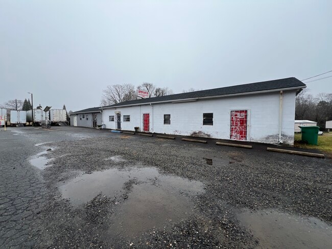
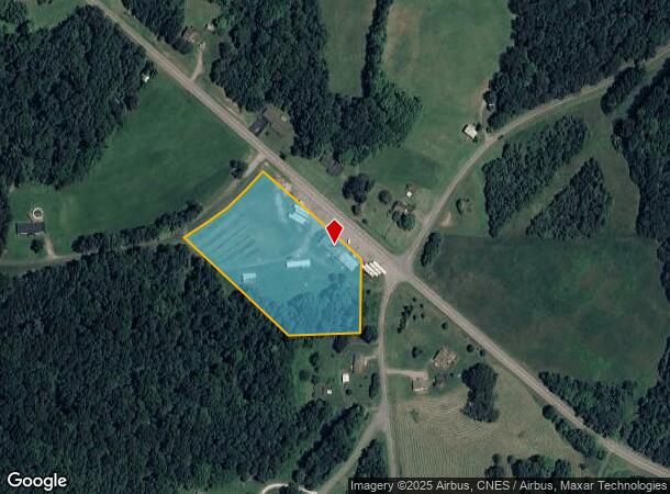
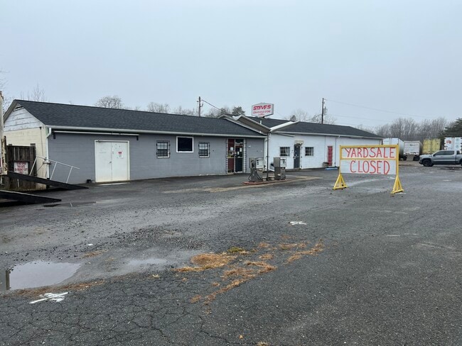
This Property Is For Sale
NEARBY LISTINGS FOR SALE OR LEASE
-
-
View all Mayodan listings for sale on LoopNet.com
Property Detail
854 Nc Highway 770
115484
Map 2 Property Of Eliza V Cardwell Estat
Mobilemanufacturedhomeregardlessoflandownership
LOT NC 770
X
Rockingham
3710790900J
North Carolina
2025
3.29 AC
2025
Rockingham County
040700
Greensboro/Winston-Salem
3,472 SF
Greensboro-High Point, NC
DEMOGRAPHICS near 854 Nc Highway 770
1 mile
3 mile
5 mile
2024 Total Population
236
1,351
5,914
2029 Population
245
1,402
6,075
Pop Growth 2024-2029
+ 3.81%
+ 3.77%
+ 2.72%
Average Age
46
46
46
2024 Total Households
100
585
2,642
HH Growth 2024-2029
+ 3.00%
+ 3.59%
+ 2.54%
Median Household Inc
$73,124
$63,409
$46,605
Avg Household Size
2.30
2.30
2.20
2024 Avg HH Vehicles
3.00
3.00
2.00
Median Home Value
$143,181
$133,009
$122,208
Median Year Built
1979
1979
1978
Nearby Places
Map Layers
Map Styles
 Street
 Aerial
Transit
 Traffic
 Biking
Places
Listings with unknown addresses are not visible on the map
- Restaurants
- Banks
- Shops
- Fitness
- Groceries
PUBLIC TRANSPORTATION
AIRPORT
Piedmont Triad International
Drive
Walk
Distance
Piedmont Triad International
53 min
37.2 mi
Freight Ports
Virginia Port Authority - Richmond
Drive
Walk
Distance
Virginia Port Authority - Richmond
245 min
191.3 mi
Nearby Properties
Address
Land Use
TOTAL SIZE
Lot Size
Zoning
Address
Land Use
TOTAL SIZE
Lot Size
Zoning
3,272 SF
609.32 AC
R-A
Address
Land Use
TOTAL SIZE
Lot Size
Zoning
5,857 SF
96.12 AC
IN MORE TH
Address
Land Use
TOTAL SIZE
Lot Size
Zoning
1,176 SF
719.34 AC
RES AG COU
Address
Land Use
TOTAL SIZE
Lot Size
Zoning
1,984 SF
484.45 AC
RES AG COU
Address
Land Use
TOTAL SIZE
Lot Size
Zoning
6,144 SF
6.88 AC
RES PROTEC
Address
Land Use
TOTAL SIZE
Lot Size
Zoning
2,696 SF
265.82 AC
RES AG COU
Address
Land Use
TOTAL SIZE
Lot Size
Zoning
1,563 SF
53 AC
R-A
Address
Land Use
TOTAL SIZE
Lot Size
Zoning
2,795 SF
11.53 AC
R-A
Address
Land Use
TOTAL SIZE
Lot Size
Zoning
3,595 SF
7.30 AC
RES AG COU
Address
Land Use
TOTAL SIZE
Lot Size
Zoning
1,384 SF
410.78 AC
RES AG COU
Address
Land Use
TOTAL SIZE
Lot Size
Zoning
4,056 SF
86.93 AC
RES AG COU
Address
Land Use
TOTAL SIZE
Lot Size
Zoning
219 AC
R-A
Address
Land Use
TOTAL SIZE
Lot Size
Zoning
2,215 SF
3.64 AC
RES AG COU
Address
Land Use
TOTAL SIZE
Lot Size
Zoning
3,306 SF
14.95 AC
RES AG COU
Address
Land Use
TOTAL SIZE
Lot Size
Zoning
3,204 SF
2.48 AC
RES AG COU
Address
Land Use
TOTAL SIZE
Lot Size
Zoning
2,009 SF
88.54 AC
R-A
Address
Land Use
TOTAL SIZE
Lot Size
Zoning
2,619 SF
4.97 AC
RES AG COU
Address
Land Use
TOTAL SIZE
Lot Size
Zoning
3,104 SF
15.24 AC
RES AG COU
Address
Land Use
TOTAL SIZE
Lot Size
Zoning
2,459 SF
58 AC
R-A
Address
Land Use
TOTAL SIZE
Lot Size
Zoning
2,224 SF
14.08 AC
RES AG COU
Address
Land Use
TOTAL SIZE
Lot Size
Zoning
295.22 AC
RES AG COU
Address
Land Use
TOTAL SIZE
Lot Size
Zoning
5,792 SF
2.93 AC
RES AG COU
Address
Land Use
TOTAL SIZE
Lot Size
Zoning
2,912 SF
RES AG COU
Address
Land Use
TOTAL SIZE
Lot Size
Zoning
1,848 SF
56.13 AC
RES AG COU
Address
Land Use
TOTAL SIZE
Lot Size
Zoning
2,352 SF
35.37 AC
RES AG COU
Address
Land Use
TOTAL SIZE
Lot Size
Zoning
2,374 SF
15.90 AC
RES AG COU
Address
Land Use
TOTAL SIZE
Lot Size
Zoning
2,445 SF
38.76 AC
RES AG COU
Address
Land Use
TOTAL SIZE
Lot Size
Zoning
2,076 SF
8.83 AC
RES AG COU
Address
Land Use
TOTAL SIZE
Lot Size
Zoning
672 SF
81.07 AC
R-A
Address
Land Use
TOTAL SIZE
Lot Size
Zoning
3,107 SF
54.12 AC
RES AG COU
The World's #1 Commercial Real Estate Marketplace
Connect with us
© 2026 CoStar Group
The information above has been obtained from sources believed reliable. While we do not doubt its accuracy we have not verified it and make no guarantee, warranty or representation about it. It is your responsibility to independently confirm its accuracy and completeness. Any projections, opinions, assumptions, or estimates used are for example only and do not represent the current or future performance of the property. The value of this transaction to you depends on tax and other factors which should be evaluated by your tax, financial, and legal advisors. You and your advisors should conduct a careful, independent investigation of the property to determine to your satisfaction the suitability of the property for your needs.