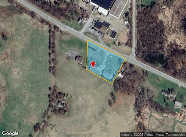
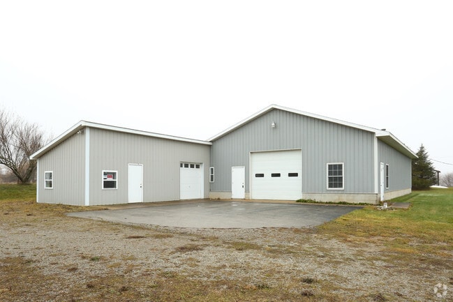
Property Record
8543 M 50, Onsted, MI 49265

NEARBY LISTINGS FOR SALE OR LEASE
Property Detail
8543 M 50
CA0-123-1350-00
THAT PART OF NE 1/4 OF NW 1/4 SEC 23 T5S- R2E COMM ON N AND S 1/4 LI AT A PT 497.10 FT S 1 DEG 09' W FROM N 1/4 POST TH N 63
Commercialnec
Lenawee
X
Michigan
26091C0050D
t
2024
2.07 AC
2025
Lenawee County
060301
Toledo
4,752 SF
Adrian, MI
DEMOGRAPHICS near 8543 M 50
1 Mile
3 Mile
5 Mile
2024 Total Population
413
5,778
10,933
2029 Population
416
5,826
11,102
Pop Growth 2024-2029
+ 0.73%
+ 0.83%
+ 1.55%
Average Age
47
46
47
2024 Total Households
175
2,441
4,638
HH Growth 2024-2029
+ 0.57%
+ 0.70%
+ 1.60%
Median Household Inc
$71,562
$74,174
$74,017
Avg Household Size
2.40
2.40
2.30
2024 Avg HH Vehicles
2.00
2.00
2.00
Median Home Value
$250,909
$239,066
$237,569
Median Year Built
1985
1978
1976
Nearby Places
Map Layers
Map Styles
 Street
 Aerial
- Restaurants
- Banks
- Shops
- Fitness
- Groceries
SALE & LEASE HISTORY
LISTING DATE
SALE/LEASE

Jan 05, 2017
For Sale
Nearby Properties
Address
Land Use
TOTAL SIZE
Lot Size
Zoning
Address
Land Use
TOTAL SIZE
Lot Size
Zoning
127,350 SF
15.18 AC
CI
Address
Land Use
TOTAL SIZE
Lot Size
Zoning
39,806 SF
8.61 AC
IN
Address
Land Use
TOTAL SIZE
Lot Size
Zoning
3,577 SF
1.75 AC
CI
Address
Land Use
TOTAL SIZE
Lot Size
Zoning
8,244 SF
2.12 AC
CI
Address
Land Use
TOTAL SIZE
Lot Size
Zoning
3,056 SF
0.31 AC
RE
Address
Land Use
TOTAL SIZE
Lot Size
Zoning
9,278 SF
3.32 AC
CI
Address
Land Use
TOTAL SIZE
Lot Size
Zoning
1,821 SF
0.36 AC
CI
Address
Land Use
TOTAL SIZE
Lot Size
Zoning
0.91 AC
Address
Land Use
TOTAL SIZE
Lot Size
Zoning
7,200 SF
4.52 AC
Address
Land Use
TOTAL SIZE
Lot Size
Zoning
35.63 AC
RE
Address
Land Use
TOTAL SIZE
Lot Size
Zoning
20,334 SF
4.35 AC
CI
Address
Land Use
TOTAL SIZE
Lot Size
Zoning
6,078 SF
1.39 AC
CI
Address
Land Use
TOTAL SIZE
Lot Size
Zoning
6,930 SF
0.84 AC
Address
Land Use
TOTAL SIZE
Lot Size
Zoning
33,340 SF
1.46 AC
CI
Address
Land Use
TOTAL SIZE
Lot Size
Zoning
5,998 SF
1.84 AC
IN
Address
Land Use
TOTAL SIZE
Lot Size
Zoning
127.66 AC
AG
Address
Land Use
TOTAL SIZE
Lot Size
Zoning
2,133 SF
1.57 AC
CI
Address
Land Use
TOTAL SIZE
Lot Size
Zoning
8,800 SF
10.03 AC
Address
Land Use
TOTAL SIZE
Lot Size
Zoning
1,960 SF
1 AC
AG
Address
Land Use
TOTAL SIZE
Lot Size
Zoning
37,924 SF
14.39 AC
CI
Address
Land Use
TOTAL SIZE
Lot Size
Zoning
11,832 SF
2.70 AC
CI
Address
Land Use
TOTAL SIZE
Lot Size
Zoning
98 AC
AG
Address
Land Use
TOTAL SIZE
Lot Size
Zoning
116.59 AC
AG
Address
Land Use
TOTAL SIZE
Lot Size
Zoning
10,000 SF
61.18 AC
CI
Address
Land Use
TOTAL SIZE
Lot Size
Zoning
94.04 AC
Address
Land Use
TOTAL SIZE
Lot Size
Zoning
4,032 SF
1.14 AC
CI
Address
Land Use
TOTAL SIZE
Lot Size
Zoning
1,774 SF
92.35 AC
Address
Land Use
TOTAL SIZE
Lot Size
Zoning
1.83 AC
IN
Address
Land Use
TOTAL SIZE
Lot Size
Zoning
77.63 AC
AG
Address
Land Use
TOTAL SIZE
Lot Size
Zoning
7,350 SF
6.08 AC
CI
The World's #1 Commercial Real Estate Marketplace
Connect with us
© 2025 CoStar Group
The information above has been obtained from sources believed reliable. While we do not doubt its accuracy we have not verified it and make no guarantee, warranty or representation about it. It is your responsibility to independently confirm its accuracy and completeness. Any projections, opinions, assumptions, or estimates used are for example only and do not represent the current or future performance of the property. The value of this transaction to you depends on tax and other factors which should be evaluated by your tax, financial, and legal advisors. You and your advisors should conduct a careful, independent investigation of the property to determine to your satisfaction the suitability of the property for your needs.