Property Record
8545 S Staples, , TX

Property Detail
8545 S Staples
Corpus Christi
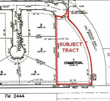
BOTANICAL GARDEN PARK UNIT 1 BLK 1 LOT 4 ACS 17.433
Corpus Christi, TX
NUECES
506484
Texas
Commercialnec
4
AE The base floodplain where base flood elevations are provided. AE Zones are now used on new format FIRMs instead of A1-A30 Zones.
17.43 AC
0
South Side
2025
NEARBY LISTINGS FOR SALE OR LEASE
DEMOGRAPHICS near 8545 S Staples
1 mile
3 mile
5 mile
2024 Total Population
3,991
52,598
118,064
2029 Population
3,966
52,310
117,019
Pop Growth 2024-2029
(0.63%)
(0.55%)
(0.89%)
Average Age
39
37
38
2024 Total Households
1,283
18,940
44,150
HH Growth 2024-2029
(0.86%)
(0.87%)
(1.11%)
Median Household Inc
$147,820
$91,818
$76,312
Avg Household Size
3.10
2.70
2.60
2024 Avg HH Vehicles
3.00
2.00
2.00
Median Home Value
$464,838
$277,122
$248,437
Median Year Built
2003
1997
1989
Nearby Places
Map Layers
Map Styles
 Street
 Aerial
Transit
 Traffic
 Biking
Places
Listings with unknown addresses are not visible on the map
- Restaurants
- Banks
- Shops
- Fitness
- Groceries
PUBLIC TRANSPORTATION
AIRPORT
Corpus Christi International
Drive
Walk
Distance
Corpus Christi International
24 min
16.3 mi
Freight Ports
Port of Corpus Christi
Drive
Walk
Distance
Port of Corpus Christi
20 min
14.9 mi
Nearby Properties
Address
Land Use
TOTAL SIZE
Lot Size
Zoning
Address
Land Use
TOTAL SIZE
Lot Size
Zoning
248,852 SF
50.64 AC
Address
Land Use
TOTAL SIZE
Lot Size
Zoning
380,000 SF
71.08 AC
Address
Land Use
TOTAL SIZE
Lot Size
Zoning
97,505 SF
29.76 AC
B-4
Address
Land Use
TOTAL SIZE
Lot Size
Zoning
273,740 SF
16.74 AC
A1
Address
Land Use
TOTAL SIZE
Lot Size
Zoning
111,464 SF
18.63 AC
R1C
Address
Land Use
TOTAL SIZE
Lot Size
Zoning
96,546 SF
19.99 AC
Address
Land Use
TOTAL SIZE
Lot Size
Zoning
88,260 SF
5 AC
Address
Land Use
TOTAL SIZE
Lot Size
Zoning
126,787 SF
13.58 AC
R1B
Address
Land Use
TOTAL SIZE
Lot Size
Zoning
79,107 SF
9.54 AC
R1B
Address
Land Use
TOTAL SIZE
Lot Size
Zoning
9,202 SF
126.97 AC
R1B
Address
Land Use
TOTAL SIZE
Lot Size
Zoning
81,798 SF
23.13 AC
A2
Address
Land Use
TOTAL SIZE
Lot Size
Zoning
68,535 SF
10.88 AC
V
Address
Land Use
TOTAL SIZE
Lot Size
Zoning
174,134 SF
19.26 AC
B4
Address
Land Use
TOTAL SIZE
Lot Size
Zoning
83,945 SF
13.34 AC
R2
Address
Land Use
TOTAL SIZE
Lot Size
Zoning
56,218 SF
15 AC
Address
Land Use
TOTAL SIZE
Lot Size
Zoning
77,977 SF
11.93 AC
B-4
Address
Land Use
TOTAL SIZE
Lot Size
Zoning
157,011 SF
15.44 AC
Address
Land Use
TOTAL SIZE
Lot Size
Zoning
2,400 SF
4.78 AC
Address
Land Use
TOTAL SIZE
Lot Size
Zoning
49,640 SF
9.99 AC
B4
Address
Land Use
TOTAL SIZE
Lot Size
Zoning
44,115 SF
3.44 AC
R1B
Address
Land Use
TOTAL SIZE
Lot Size
Zoning
38,995 SF
9 AC
A1
Address
Land Use
TOTAL SIZE
Lot Size
Zoning
36,770 SF
11.56 AC
B-4,R-1B
Address
Land Use
TOTAL SIZE
Lot Size
Zoning
46,934 SF
4.76 AC
B1SP06
Address
Land Use
TOTAL SIZE
Lot Size
Zoning
2,200 SF
4.60 AC
B-4
Address
Land Use
TOTAL SIZE
Lot Size
Zoning
70,096 SF
10.17 AC
R1B
Address
Land Use
TOTAL SIZE
Lot Size
Zoning
221.94 AC
FR
Address
Land Use
TOTAL SIZE
Lot Size
Zoning
16,008 SF
13.59 AC
B4
Address
Land Use
TOTAL SIZE
Lot Size
Zoning
39,779 SF
5.39 AC
Address
Land Use
TOTAL SIZE
Lot Size
Zoning
60,270 SF
4.61 AC
B4
Address
Land Use
TOTAL SIZE
Lot Size
Zoning
44,595 SF
3.55 AC
B-1
The World's #1 Commercial Real Estate Marketplace
Connect with us
© 2026 CoStar Group
The information above has been obtained from sources believed reliable. While we do not doubt its accuracy we have not verified it and make no guarantee, warranty or representation about it. It is your responsibility to independently confirm its accuracy and completeness. Any projections, opinions, assumptions, or estimates used are for example only and do not represent the current or future performance of the property. The value of this transaction to you depends on tax and other factors which should be evaluated by your tax, financial, and legal advisors. You and your advisors should conduct a careful, independent investigation of the property to determine to your satisfaction the suitability of the property for your needs.