Property Record
25 S Peoria St, Chicago, IL 60607
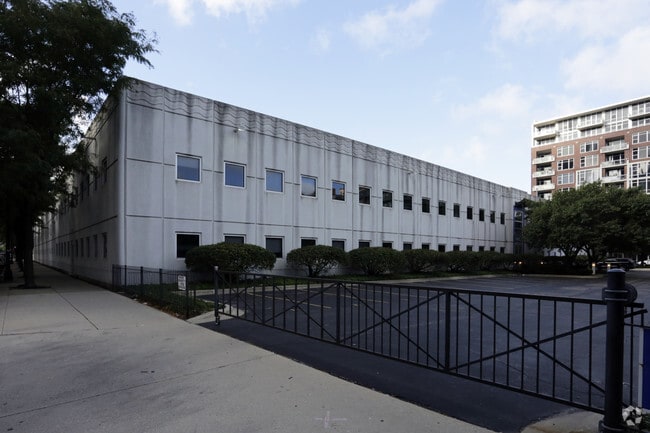
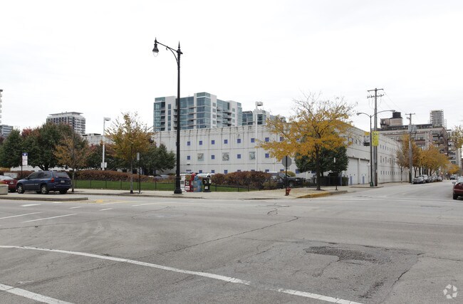
Property Detail
25 S Peoria St
Chicago-Naperville-Elgin, IL-IN
L3-L16 B2 CHICAGO SUBD E1/2 NE1/4 S17 T39N R14E
17-17-208-017-0000
COOK
Apartment
Illinois
PD 1377
3
B and X Area of moderate flood hazard, usually the area between the limits of the 100-year and 500-year floods.
0.29 AC
2023
North Chicago
2025
Chicago
833100
NEARBY LISTINGS FOR SALE OR LEASE
DEMOGRAPHICS near 25 S Peoria St
1 mile
3 mile
5 mile
2025 Total Population
68,062
463,363
928,951
2030 Population
70,682
469,328
923,718
Pop Growth 2025-2030
+ 3.85%
+ 1.29%
(0.56%)
Average Age
35
37
37
2025 Total Households
37,862
241,144
439,515
HH Growth 2025-2030
+ 3.68%
+ 1.42%
(0.15%)
Median Household Inc
$137,311
$116,006
$99,933
Avg Household Size
1.70
1.80
2.00
2025 Avg HH Vehicles
1.00
1.00
1.00
Median Home Value
$492,511
$515,092
$476,121
Median Year Built
2002
1984
1968
Nearby Places
Map Layers
Map Styles
 Street
 Aerial
Transit
 Traffic
 Biking
Places
Listings with unknown addresses are not visible on the map
- Restaurants
- Banks
- Shops
- Fitness
- Groceries
PUBLIC TRANSPORTATION
TRANSIT/SUBWAY
Uic-Halsted Station (Blue Line - Chicago Transit Authority "L" Trains (The "L"))
Drive
Walk
Distance
Uic-Halsted Station (Blue Line - Chicago Transit Authority "L" Trains (The "L"))
4 min
7 min
0.4 mi
Morgan (Green Line - Chicago Transit Authority)
Drive
Walk
Distance
Morgan (Green Line - Chicago Transit Authority)
1 min
9 min
0.4 mi
Clinton Station (Green, Pink Lines) (Green Line - Chicago Transit Authority "L" Trains (The "L"), Pink Line - Chicago Transit Authority "L" Trains (The "L"))
Drive
Walk
Distance
Clinton Station (Green, Pink Lines) (Green Line - Chicago Transit Authority "L" Trains (The "L"), Pink Line - Chicago Transit Authority "L" Trains (The "L"))
2 min
14 min
0.8 mi
Clinton Station (Blue Line) (Blue Line - Chicago Transit Authority "L" Trains (The "L"))
Drive
Walk
Distance
Clinton Station (Blue Line) (Blue Line - Chicago Transit Authority "L" Trains (The "L"))
2 min
15 min
0.8 mi
Racine Station (Blue Line - Chicago Transit Authority "L" Trains (The "L"))
Drive
Walk
Distance
Racine Station (Blue Line - Chicago Transit Authority "L" Trains (The "L"))
3 min
15 min
0.8 mi
COMMUTER RAIL
Chicago Ogilvie Transportation Center (Union Pacific North Line - Northeast Illinois Regional Commuter Railroad (Metra), Union Pacific Northwest Line - Northeast Illinois Regional Commuter Railroad (Metra), Union Pacific West Line - Northeast Illinois Regional Commuter Railroad (Metra))
Drive
Walk
Distance
Chicago Ogilvie Transportation Center (Union Pacific North Line - Northeast Illinois Regional Commuter Railroad (Metra), Union Pacific Northwest Line - Northeast Illinois Regional Commuter Railroad (Metra), Union Pacific West Line - Northeast Illinois Regional Commuter Railroad (Metra))
1 min
11 min
0.6 mi
Chicago Union Station (Burlington Northern-Santa Fe Railway Line - Northeast Illinois Regional Commuter Railroad (Metra), Heritage Corridor Line - Northeast Illinois Regional Commuter Railroad (Metra), Milwaukee District North Line - Northeast Illinois Regional Commuter Railroad (Metra), Milwaukee District West Line - Northeast Illinois Regional Commuter Railroad (Metra), North Central Service - Northeast Illinois Regional Commuter Railroad (Metra), SouthWest Service - Northeast Illinois Regional Commuter Railroad (Metra))
Drive
Walk
Distance
Chicago Union Station (Burlington Northern-Santa Fe Railway Line - Northeast Illinois Regional Commuter Railroad (Metra), Heritage Corridor Line - Northeast Illinois Regional Commuter Railroad (Metra), Milwaukee District North Line - Northeast Illinois Regional Commuter Railroad (Metra), Milwaukee District West Line - Northeast Illinois Regional Commuter Railroad (Metra), North Central Service - Northeast Illinois Regional Commuter Railroad (Metra), SouthWest Service - Northeast Illinois Regional Commuter Railroad (Metra))
2 min
12 min
0.6 mi
AIRPORT
Chicago Midway International
Drive
Walk
Distance
Chicago Midway International
17 min
10.5 mi
Chicago O'Hare International
Drive
Walk
Distance
Chicago O'Hare International
26 min
17.2 mi
Freight Ports
Port Milwaukee
Drive
Walk
Distance
Port Milwaukee
104 min
85.5 mi
SALE & LEASE HISTORY
LISTING DATE
SALE/LEASE

Sep 25, 2016
For Lease
Nearby Properties
Address
Land Use
TOTAL SIZE
Lot Size
Zoning
Address
Land Use
TOTAL SIZE
Lot Size
Zoning
4,667,723 SF
2.94 AC
DC-16
Address
Land Use
TOTAL SIZE
Lot Size
Zoning
3,457,865 SF
3.74 AC
PD 70
Address
Land Use
TOTAL SIZE
Lot Size
Zoning
1,546,909 SF
0.98 AC
PD 1369
Address
Land Use
TOTAL SIZE
Lot Size
Zoning
1,496,448 SF
2 AC
PD 376
Address
Land Use
TOTAL SIZE
Lot Size
Zoning
1,396,750 SF
4.09 AC
PD 98
Address
Land Use
TOTAL SIZE
Lot Size
Zoning
1,362,475 SF
1.97 AC
PD 1226
Address
Land Use
TOTAL SIZE
Lot Size
Zoning
2,343,906 SF
2.32 AC
PD 70
Address
Land Use
TOTAL SIZE
Lot Size
Zoning
4,296,046 SF
6.15 AC
DC-16
Address
Land Use
TOTAL SIZE
Lot Size
Zoning
3,914,400 SF
5.70 AC
DC-16
Address
Land Use
TOTAL SIZE
Lot Size
Zoning
1,810,145 SF
1.03 AC
PD 365
Address
Land Use
TOTAL SIZE
Lot Size
Zoning
3,090,691 SF
3.30 AC
PD 377,PD
Address
Land Use
TOTAL SIZE
Lot Size
Zoning
1,215,367 SF
3.76 AC
PD 675
Address
Land Use
TOTAL SIZE
Lot Size
Zoning
0.82 AC
PD 1115
Address
Land Use
TOTAL SIZE
Lot Size
Zoning
0.88 AC
DC-16,PD 9
Address
Land Use
TOTAL SIZE
Lot Size
Zoning
2,750,656 SF
6.29 AC
PD 1065
Address
Land Use
TOTAL SIZE
Lot Size
Zoning
831,084 SF
2.05 AC
PD 316
Address
Land Use
TOTAL SIZE
Lot Size
Zoning
1,888,207 SF
2.03 AC
PD 264
Address
Land Use
TOTAL SIZE
Lot Size
Zoning
1,600,546 SF
1.04 AC
PD 191
Address
Land Use
TOTAL SIZE
Lot Size
Zoning
1,231,710 SF
2.01 AC
PD 27
Address
Land Use
TOTAL SIZE
Lot Size
Zoning
590,844 SF
0.80 AC
PD 26
Address
Land Use
TOTAL SIZE
Lot Size
Zoning
2,429,909 SF
2.93 AC
PD 882
Address
Land Use
TOTAL SIZE
Lot Size
Zoning
2,456,900 SF
0.96 AC
PD 256
Address
Land Use
TOTAL SIZE
Lot Size
Zoning
2,612,517 SF
1.28 AC
PD 256
Address
Land Use
TOTAL SIZE
Lot Size
Zoning
2.06 AC
DX-16
Address
Land Use
TOTAL SIZE
Lot Size
Zoning
1,272,928 SF
2.33 AC
PD 368
Address
Land Use
TOTAL SIZE
Lot Size
Zoning
1.23 AC
PD 291
Address
Land Use
TOTAL SIZE
Lot Size
Zoning
1,502,279 SF
3.79 AC
PD 98
Address
Land Use
TOTAL SIZE
Lot Size
Zoning
1.54 AC
PD 743
Address
Land Use
TOTAL SIZE
Lot Size
Zoning
1,559,966 SF
1.38 AC
DC-12
Address
Land Use
TOTAL SIZE
Lot Size
Zoning
1,493,502 SF
1.31 AC
PD 70
The World's #1 Commercial Real Estate Marketplace
Connect with us
© 2026 CoStar Group
The information above has been obtained from sources believed reliable. While we do not doubt its accuracy we have not verified it and make no guarantee, warranty or representation about it. It is your responsibility to independently confirm its accuracy and completeness. Any projections, opinions, assumptions, or estimates used are for example only and do not represent the current or future performance of the property. The value of this transaction to you depends on tax and other factors which should be evaluated by your tax, financial, and legal advisors. You and your advisors should conduct a careful, independent investigation of the property to determine to your satisfaction the suitability of the property for your needs.