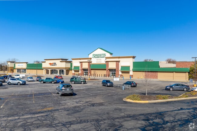
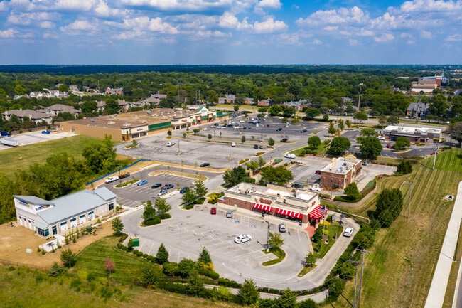
Property Record
8550 Maurer Rd, Lenexa, KS 66219

Property Detail
8550 Maurer Rd
IF241229-2013
29-12-24 BG SE CR SW1/4 W 585N 45 TO INTRC N RTWY/L 87 ST & W RTWY/L MAURER RD N 84.66 NLY ALG CUR 179.48 TO TRUE PTBG W 322.24 N 26.66 W 151.23 N 350.67 E 74.30 N 160 W 190 N 114.33 E 793.51 TO W/L RD S 14.36 SLY& SWLY ALG CUR RT 357.41 SW 212.29 SW
Regionalshoppingcenterormallwithanchorstore
Johnson
CP2
Kansas
B and X Area of moderate flood hazard, usually the area between the limits of the 100-year and 500-year floods.
87
2024
8.85 AC
2025
Northwest Johnson County
052410
Kansas City
90,441 SF
Kansas City, MO-KS
NEARBY LISTINGS FOR SALE OR LEASE
DEMOGRAPHICS near 8550 Maurer Rd
1 mile
3 mile
5 mile
2025 Total Population
13,916
57,229
176,887
2030 Population
14,327
58,961
182,890
Pop Growth 2025-2030
+ 2.95%
+ 3.03%
+ 3.39%
Average Age
39
41
40
2025 Total Households
6,476
24,761
73,867
HH Growth 2025-2030
+ 3.15%
+ 3.17%
+ 3.48%
Median Household Inc
$91,144
$92,607
$93,110
Avg Household Size
2.10
2.20
2.30
2025 Avg HH Vehicles
2.00
2.00
2.00
Median Home Value
$376,688
$366,758
$350,816
Median Year Built
1994
1987
1985
Nearby Places
Map Layers
Map Styles
 Street
 Aerial
Layers
 Traffic
 Biking
Places
Listings with unknown addresses are not visible on the map
- Restaurants
- Banks
- Shops
- Fitness
- Groceries
PUBLIC TRANSPORTATION
AIRPORT
Kansas City International
Drive
Walk
Distance
Kansas City International
40 min
33.5 mi
SALE & LEASE HISTORY
LISTING DATE
SALE/LEASE

Sep 25, 2016
For Lease
Nearby Properties
Address
Land Use
TOTAL SIZE
Lot Size
Zoning
Address
Land Use
TOTAL SIZE
Lot Size
Zoning
787,363 SF
88.91 AC
RP5
Address
Land Use
TOTAL SIZE
Lot Size
Zoning
203,079 SF
8.10 AC
BP2
Address
Land Use
TOTAL SIZE
Lot Size
Zoning
208,693 SF
22.30 AC
BP1
Address
Land Use
TOTAL SIZE
Lot Size
Zoning
133,932 SF
3.29 AC
CC
Address
Land Use
TOTAL SIZE
Lot Size
Zoning
144,755 SF
22.19 AC
BP2
Address
Land Use
TOTAL SIZE
Lot Size
Zoning
304,926 SF
7.87 AC
CC
Address
Land Use
TOTAL SIZE
Lot Size
Zoning
129,784 SF
36.15 AC
CPO
Address
Land Use
TOTAL SIZE
Lot Size
Zoning
49,029 SF
15.02 AC
BP1
Address
Land Use
TOTAL SIZE
Lot Size
Zoning
69,872 SF
1.91 AC
CC
Address
Land Use
TOTAL SIZE
Lot Size
Zoning
120,492 SF
10 AC
R1
Address
Land Use
TOTAL SIZE
Lot Size
Zoning
141,340 SF
19.92 AC
R1
Address
Land Use
TOTAL SIZE
Lot Size
Zoning
72,994 SF
7.99 AC
RP3
Address
Land Use
TOTAL SIZE
Lot Size
Zoning
75,010 SF
24.78 AC
RP2
Address
Land Use
TOTAL SIZE
Lot Size
Zoning
204,922 SF
14.73 AC
BP2
Address
Land Use
TOTAL SIZE
Lot Size
Zoning
49,282 SF
11.89 AC
RP1
Address
Land Use
TOTAL SIZE
Lot Size
Zoning
139,880 SF
17.18 AC
R1
Address
Land Use
TOTAL SIZE
Lot Size
Zoning
36,903 SF
0.55 AC
CC
Address
Land Use
TOTAL SIZE
Lot Size
Zoning
88,866 SF
21.54 AC
RS
Address
Land Use
TOTAL SIZE
Lot Size
Zoning
143,055 SF
8.11 AC
BP1
Address
Land Use
TOTAL SIZE
Lot Size
Zoning
85,469 SF
10.32 AC
CPO
Address
Land Use
TOTAL SIZE
Lot Size
Zoning
56,347 SF
0.76 AC
CC
Address
Land Use
TOTAL SIZE
Lot Size
Zoning
35,848 SF
74.74 AC
R1
Address
Land Use
TOTAL SIZE
Lot Size
Zoning
279,588 SF
19.50 AC
RP5
Address
Land Use
TOTAL SIZE
Lot Size
Zoning
140,608 SF
11.33 AC
BP2
Address
Land Use
TOTAL SIZE
Lot Size
Zoning
186,546 SF
20.42 AC
CP2
Address
Land Use
TOTAL SIZE
Lot Size
Zoning
83,186 SF
28.33 AC
RP-4
Address
Land Use
TOTAL SIZE
Lot Size
Zoning
91,908 SF
9.55 AC
BP2
Address
Land Use
TOTAL SIZE
Lot Size
Zoning
93,068 SF
9.06 AC
R1
Address
Land Use
TOTAL SIZE
Lot Size
Zoning
1,995,710 SF
150.87 AC
BP2
Address
Land Use
TOTAL SIZE
Lot Size
Zoning
66,314 SF
8.47 AC
R1
The World's #1 Commercial Real Estate Marketplace
Connect with us
© 2026 CoStar Group
The information above has been obtained from sources believed reliable. While we do not doubt its accuracy we have not verified it and make no guarantee, warranty or representation about it. It is your responsibility to independently confirm its accuracy and completeness. Any projections, opinions, assumptions, or estimates used are for example only and do not represent the current or future performance of the property. The value of this transaction to you depends on tax and other factors which should be evaluated by your tax, financial, and legal advisors. You and your advisors should conduct a careful, independent investigation of the property to determine to your satisfaction the suitability of the property for your needs.