Property Record
8550 State Route 339, Vincent, OH 45784
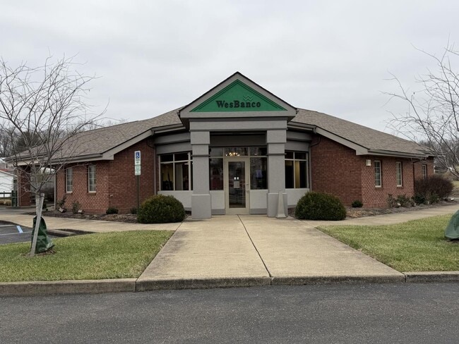


Property Detail
8550 State Route 339
Marietta, OH
R10 T3 S21 160 AC LOT 102 8 .84 AC
0500-55027-000
WASHINGTON
Financialbuilding
Ohio
B and X Area of moderate flood hazard, usually the area between the limits of the 100-year and 500-year floods.
102
2025
0.84 AC
2024
Ohio South Area
021700
Other Market Areas
1,810 SF
NEARBY LISTINGS FOR SALE OR LEASE
-
-
View all Vincent listings for sale on LoopNet.com
DEMOGRAPHICS near 8550 State Route 339
1 mile
3 mile
5 mile
2025 Total Population
419
2,293
5,264
2030 Population
407
2,230
5,146
Pop Growth 2025-2030
(2.86%)
(2.75%)
(2.24%)
Average Age
44
44
43
2025 Total Households
165
903
2,040
HH Growth 2025-2030
(3.03%)
(2.77%)
(2.30%)
Median Household Inc
$80,750
$78,935
$79,264
Avg Household Size
2.50
2.50
2.60
2025 Avg HH Vehicles
2.00
2.00
2.00
Median Home Value
$237,333
$237,215
$232,188
Median Year Built
1989
1988
1985
Nearby Places
Map Layers
Map Styles
 Street
 Aerial
Layers
 Traffic
 Biking
Places
Listings with unknown addresses are not visible on the map
- Restaurants
- Banks
- Shops
- Fitness
- Groceries
Nearby Properties
Address
Land Use
TOTAL SIZE
Lot Size
Zoning
Address
Land Use
TOTAL SIZE
Lot Size
Zoning
64,976 SF
56.86 AC
Address
Land Use
TOTAL SIZE
Lot Size
Zoning
49,426 SF
7.44 AC
Address
Land Use
TOTAL SIZE
Lot Size
Zoning
5,824 SF
2.19 AC
Address
Land Use
TOTAL SIZE
Lot Size
Zoning
9,408 SF
37.27 AC
Address
Land Use
TOTAL SIZE
Lot Size
Zoning
12,444 SF
0.94 AC
Address
Land Use
TOTAL SIZE
Lot Size
Zoning
12,254 SF
1.01 AC
Address
Land Use
TOTAL SIZE
Lot Size
Zoning
13,320 SF
0.74 AC
Address
Land Use
TOTAL SIZE
Lot Size
Zoning
6,600 SF
13.52 AC
Address
Land Use
TOTAL SIZE
Lot Size
Zoning
3,268 SF
1.53 AC
Address
Land Use
TOTAL SIZE
Lot Size
Zoning
13,265 SF
2.77 AC
Address
Land Use
TOTAL SIZE
Lot Size
Zoning
9,180 SF
0.67 AC
Address
Land Use
TOTAL SIZE
Lot Size
Zoning
780 SF
7.54 AC
Address
Land Use
TOTAL SIZE
Lot Size
Zoning
9,000 SF
0.56 AC
Address
Land Use
TOTAL SIZE
Lot Size
Zoning
187 SF
12.02 AC
Address
Land Use
TOTAL SIZE
Lot Size
Zoning
5,180 SF
0.84 AC
Address
Land Use
TOTAL SIZE
Lot Size
Zoning
144.21 AC
Address
Land Use
TOTAL SIZE
Lot Size
Zoning
2,556 SF
137.63 AC
Address
Land Use
TOTAL SIZE
Lot Size
Zoning
139.80 AC
Address
Land Use
TOTAL SIZE
Lot Size
Zoning
3,472 SF
0.98 AC
Address
Land Use
TOTAL SIZE
Lot Size
Zoning
3,964 SF
0.61 AC
Address
Land Use
TOTAL SIZE
Lot Size
Zoning
11.92 AC
Address
Land Use
TOTAL SIZE
Lot Size
Zoning
88.52 AC
Address
Land Use
TOTAL SIZE
Lot Size
Zoning
4,644 SF
1.50 AC
Address
Land Use
TOTAL SIZE
Lot Size
Zoning
83.10 AC
Address
Land Use
TOTAL SIZE
Lot Size
Zoning
8,040 SF
25.11 AC
Address
Land Use
TOTAL SIZE
Lot Size
Zoning
1,672 SF
101.15 AC
Address
Land Use
TOTAL SIZE
Lot Size
Zoning
2,800 SF
0.36 AC
Address
Land Use
TOTAL SIZE
Lot Size
Zoning
4,800 SF
1.33 AC
Address
Land Use
TOTAL SIZE
Lot Size
Zoning
79.19 AC
The World's #1 Commercial Real Estate Marketplace
Connect with us
© 2026 CoStar Group
The information above has been obtained from sources believed reliable. While we do not doubt its accuracy we have not verified it and make no guarantee, warranty or representation about it. It is your responsibility to independently confirm its accuracy and completeness. Any projections, opinions, assumptions, or estimates used are for example only and do not represent the current or future performance of the property. The value of this transaction to you depends on tax and other factors which should be evaluated by your tax, financial, and legal advisors. You and your advisors should conduct a careful, independent investigation of the property to determine to your satisfaction the suitability of the property for your needs.