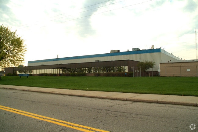
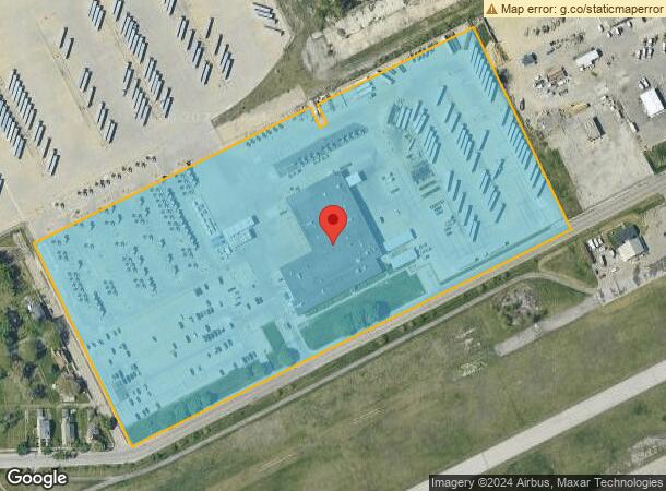
Property Record
8555 Lynch Rd, Detroit, MI 48234

NEARBY LISTINGS FOR SALE OR LEASE
Property Detail
8555 Lynch Rd
17-00-230-70-02L
Enos Laderoots
Industrialgeneral
N LYNCH RD PT OF 3 THRU 7 AND VAC 16.5 FT LANE S & ADJ ENOS LADEROOTS SUB L1 P234 PLATS, W C R 17/448 ALSO PT OF 4 THRU 6 J P LADEROOTS SUB PRO FILE 3996, W C R 17/447 ALL DESC AS FOLS BEG AT PTE IN N LINE LYNCH RD 56 FT WD BG ALSO IN E LINE WOOD AVE
X
Wayne
26163C0125E
Michigan
2025
17.71 AC
2025
Detroit East
505700
Detroit
65,490 SF
Detroit-Warren-Dearborn, MI
DEMOGRAPHICS near 8555 Lynch Rd
1 Mile
3 Mile
5 Mile
2024 Total Population
8,540
136,455
380,234
2029 Population
8,760
137,764
379,818
Pop Growth 2024-2029
+ 2.58%
+ 0.96%
(0.11%)
Average Age
39
37
38
2024 Total Households
3,157
47,797
150,519
HH Growth 2024-2029
+ 2.63%
+ 1.36%
(0.14%)
Median Household Inc
$35,463
$34,650
$38,286
Avg Household Size
2.60
2.70
2.40
2024 Avg HH Vehicles
1.00
1.00
1.00
Median Home Value
$59,582
$68,635
$84,067
Median Year Built
1948
1948
1951
Nearby Places
Map Layers
Map Styles
 Street
 Aerial
- Restaurants
- Banks
- Shops
- Fitness
- Groceries
PUBLIC TRANSPORTATION
COMMUTER RAIL
DRIVE
WALK
Distance
11 min
5.2 mi
AIRPORT
Windsor International
DRIVE
WALK
Distance
Windsor International
36 min
16.7 mi
Detroit Metro Wayne County
DRIVE
WALK
Distance
Detroit Metro Wayne County
40 min
26.1 mi
Freight Ports
DRIVE
WALK
Distance
85 min
66.9 mi
Nearby Properties
Address
Land Use
TOTAL SIZE
Lot Size
Zoning
Address
Land Use
TOTAL SIZE
Lot Size
Zoning
3,793,609 SF
265.70 AC
M4
Address
Land Use
TOTAL SIZE
Lot Size
Zoning
2,005,073 SF
108.66 AC
M4
Address
Land Use
TOTAL SIZE
Lot Size
Zoning
996,200 SF
2.14 AC
Address
Land Use
TOTAL SIZE
Lot Size
Zoning
482,649 SF
M4
Address
Land Use
TOTAL SIZE
Lot Size
Zoning
506,404 SF
198 AC
M4
Address
Land Use
TOTAL SIZE
Lot Size
Zoning
892,351 SF
92.45 AC
I
Address
Land Use
TOTAL SIZE
Lot Size
Zoning
564,958 SF
9.69 AC
M4
Address
Land Use
TOTAL SIZE
Lot Size
Zoning
197,670 SF
42.84 AC
M4
Address
Land Use
TOTAL SIZE
Lot Size
Zoning
144,578 SF
7.10 AC
PD
Address
Land Use
TOTAL SIZE
Lot Size
Zoning
300,000 SF
0.29 AC
M4
Address
Land Use
TOTAL SIZE
Lot Size
Zoning
405,004 SF
28.13 AC
M4
Address
Land Use
TOTAL SIZE
Lot Size
Zoning
358,327 SF
M4
Address
Land Use
TOTAL SIZE
Lot Size
Zoning
455,634 SF
0.58 AC
Address
Land Use
TOTAL SIZE
Lot Size
Zoning
116,060 SF
6.95 AC
R2
Address
Land Use
TOTAL SIZE
Lot Size
Zoning
302,305 SF
M4
Address
Land Use
TOTAL SIZE
Lot Size
Zoning
410,359 SF
27.52 AC
M4
Address
Land Use
TOTAL SIZE
Lot Size
Zoning
286,023 SF
M4
Address
Land Use
TOTAL SIZE
Lot Size
Zoning
641,836 SF
20.69 AC
M4
Address
Land Use
TOTAL SIZE
Lot Size
Zoning
224,148 SF
8.59 AC
M4
Address
Land Use
TOTAL SIZE
Lot Size
Zoning
307,262 SF
M4
Address
Land Use
TOTAL SIZE
Lot Size
Zoning
72,940 SF
83.37 AC
M4
Address
Land Use
TOTAL SIZE
Lot Size
Zoning
88,695 SF
6.53 AC
PD
Address
Land Use
TOTAL SIZE
Lot Size
Zoning
115,839 SF
8.54 AC
M4
Address
Land Use
TOTAL SIZE
Lot Size
Zoning
192,452 SF
10.89 AC
M4
Address
Land Use
TOTAL SIZE
Lot Size
Zoning
76,856 SF
1.27 AC
R5
Address
Land Use
TOTAL SIZE
Lot Size
Zoning
218,188 SF
33.22 AC
M4
Address
Land Use
TOTAL SIZE
Lot Size
Zoning
70,152 SF
3.43 AC
M2
Address
Land Use
TOTAL SIZE
Lot Size
Zoning
233,876 SF
8.20 AC
Address
Land Use
TOTAL SIZE
Lot Size
Zoning
4,344 SF
44.72 AC
M4
Address
Land Use
TOTAL SIZE
Lot Size
Zoning
49,807 SF
0.84 AC
PD
The World's #1 Commercial Real Estate Marketplace
Connect with us
© 2026 CoStar Group
The information above has been obtained from sources believed reliable. While we do not doubt its accuracy we have not verified it and make no guarantee, warranty or representation about it. It is your responsibility to independently confirm its accuracy and completeness. Any projections, opinions, assumptions, or estimates used are for example only and do not represent the current or future performance of the property. The value of this transaction to you depends on tax and other factors which should be evaluated by your tax, financial, and legal advisors. You and your advisors should conduct a careful, independent investigation of the property to determine to your satisfaction the suitability of the property for your needs.